Ciutadilla | |
|---|---|
 | |
| Coordinates: 41°33′40″N 1°08′23″E / 41.56110°N 1.13976°E | |
| Country |
|
| Autonomous community |
|
| Province |
|
| Comarca |
|
| Government | |
| • mayor | Óscar Martínez Agustí (2015) [1] |
| Area | |
| • Total | 17.0 km2 (6.6 sq mi) |
| Elevation | 519 m (1,703 ft) |
| Population (2018)
[3] | |
| • Total | 206 |
| • Density | 12/km2 (31/sq mi) |
| Time zone | UTC+1 ( CET) |
| • Summer ( DST) | UTC+2 ( CEST) |
| Postal code | 25341 |
| Website |
www |
Ciutadilla is a village and municipality in the comarca of Urgell in Catalonia, Spain. Its population in 2013 was 209.
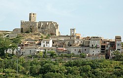
The village, the only settlement in the municipality, is situated on a hill close to where the Montblanc-to- Tàrrega highway crosses the Corb river. Its ruined castle occupies a commanding position overlooking not just the village but also the plains of Urgell and Segarra. [4] Many of the buildings in the village serve as holiday homes.
The municipality's economy depends largely on agriculture, mainly non-irrigated barley and other grains, vines, olives, and almonds, as well as pig- and poultry-farming. [4]

Ciutadilla village developed around its castle, and spread downhill. The castle is mentioned in extant 12th-century documents, and was significantly improved in the 16th century. It was badly damaged during the First Carlist War in 1835, and fell into ruins after that. [4] The municipality's population reached a peak of 872 in 1887, but has since steadily declined with the rest of the region to 209 in 2013. [5] Many archaeological remains from the Iberic, Greek and Roman periods have been found in the municipality. [4]
The main festivals in Ciutadilla are that of Saint Roch on the second weekend of August, and its patron saint Saint Michael on 29 September. [4]
- ^ "Ajuntament de Ciutadilla". Generalitat of Catalonia. Retrieved 13 November 2015.
- ^ "El municipi en xifres: Ciutadilla". Statistical Institute of Catalonia. Retrieved 23 November 2015.
- ^ Municipal Register of Spain 2018. National Statistics Institute.
- ^ a b c d e "Ciutadilla". Gran Enciclopèdia Catalana. Retrieved 13 April 2014.
- ^ "El municipi en xifres: Ciutadilla". Statistics Institute of Catalonia. Retrieved 13 April 2014.
- Official website
- Government data pages (in Catalan)
Ciutadilla | |
|---|---|
 | |
| Coordinates: 41°33′40″N 1°08′23″E / 41.56110°N 1.13976°E | |
| Country |
|
| Autonomous community |
|
| Province |
|
| Comarca |
|
| Government | |
| • mayor | Óscar Martínez Agustí (2015) [1] |
| Area | |
| • Total | 17.0 km2 (6.6 sq mi) |
| Elevation | 519 m (1,703 ft) |
| Population (2018)
[3] | |
| • Total | 206 |
| • Density | 12/km2 (31/sq mi) |
| Time zone | UTC+1 ( CET) |
| • Summer ( DST) | UTC+2 ( CEST) |
| Postal code | 25341 |
| Website |
www |
Ciutadilla is a village and municipality in the comarca of Urgell in Catalonia, Spain. Its population in 2013 was 209.
The village, the only settlement in the municipality, is situated on a hill close to where the Montblanc-to- Tàrrega highway crosses the Corb river. Its ruined castle occupies a commanding position overlooking not just the village but also the plains of Urgell and Segarra. [4] Many of the buildings in the village serve as holiday homes.
The municipality's economy depends largely on agriculture, mainly non-irrigated barley and other grains, vines, olives, and almonds, as well as pig- and poultry-farming. [4]

Ciutadilla village developed around its castle, and spread downhill. The castle is mentioned in extant 12th-century documents, and was significantly improved in the 16th century. It was badly damaged during the First Carlist War in 1835, and fell into ruins after that. [4] The municipality's population reached a peak of 872 in 1887, but has since steadily declined with the rest of the region to 209 in 2013. [5] Many archaeological remains from the Iberic, Greek and Roman periods have been found in the municipality. [4]
The main festivals in Ciutadilla are that of Saint Roch on the second weekend of August, and its patron saint Saint Michael on 29 September. [4]
- ^ "Ajuntament de Ciutadilla". Generalitat of Catalonia. Retrieved 13 November 2015.
- ^ "El municipi en xifres: Ciutadilla". Statistical Institute of Catalonia. Retrieved 23 November 2015.
- ^ Municipal Register of Spain 2018. National Statistics Institute.
- ^ a b c d e "Ciutadilla". Gran Enciclopèdia Catalana. Retrieved 13 April 2014.
- ^ "El municipi en xifres: Ciutadilla". Statistics Institute of Catalonia. Retrieved 13 April 2014.
- Official website
- Government data pages (in Catalan)


