This article relies largely or entirely on a
single source. (March 2023) |
| Cilcennin | |
|---|---|
 Western approach to Cilcennin | |
 Cilcennin Location within
Ceredigion | |
| OS grid reference | SN522602 |
| Principal area | |
| Preserved county | |
| Country | Wales |
| Sovereign state | United Kingdom |
| Postcode district | SA48 |
| Dialling code | 01570 |
| Police | Dyfed-Powys |
| Fire | Mid and West Wales |
| Ambulance | Welsh |
| UK Parliament | |
| Senedd Cymru – Welsh Parliament | |
Cilcennin is a village in the community of Ciliau Aeron, Ceredigion, west Wales. The River Aeron is to the southwest.
History
Cilcennin is the site of a historic slaughter in 1210, when Owain Goch ap Gruffydd and three hundred men attacked and killed soldiers from a superior English and Welsh troops' body under the command of their uncle Maelgwn ap Rhys. [1]
The church in Cilcennin is dedicated to St. Cannen, and was rebuilt in the 19th century through public contributions. [1]
Gallery
-
 Tafarn Commercial Inn, Cilcennin
 -
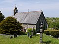 Cilcennin church
 -
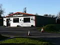 Cycle shop near Cilcennon


References
- ^ a b Lewis, Samuel (1840). A Topographical Dictionary of Wales. London: Gilbert & Rivington. p. 431. ISBN 9780598739971.

|
| This Ceredigion location article is a stub. You can help Wikipedia by expanding it. |
This article relies largely or entirely on a
single source. (March 2023) |
| Cilcennin | |
|---|---|
|
Western approach to Cilcennin | |
Cilcennin Location within
Ceredigion | |
| OS grid reference | SN522602 |
| Principal area | |
| Preserved county | |
| Country | Wales |
| Sovereign state | United Kingdom |
| Postcode district | SA48 |
| Dialling code | 01570 |
| Police | Dyfed-Powys |
| Fire | Mid and West Wales |
| Ambulance | Welsh |
| UK Parliament | |
| Senedd Cymru – Welsh Parliament | |
Cilcennin is a village in the community of Ciliau Aeron, Ceredigion, west Wales. The River Aeron is to the southwest.
History
Cilcennin is the site of a historic slaughter in 1210, when Owain Goch ap Gruffydd and three hundred men attacked and killed soldiers from a superior English and Welsh troops' body under the command of their uncle Maelgwn ap Rhys. [1]
The church in Cilcennin is dedicated to St. Cannen, and was rebuilt in the 19th century through public contributions. [1]
Gallery
-
Tafarn Commercial Inn, Cilcennin
-
Cilcennin church
-
Cycle shop near Cilcennon
References
- ^ a b Lewis, Samuel (1840). A Topographical Dictionary of Wales. London: Gilbert & Rivington. p. 431. ISBN 9780598739971.
|
| This Ceredigion location article is a stub. You can help Wikipedia by expanding it. |