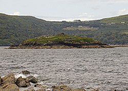
Oileán an Teampaill
[1] | |
 | |
| Monastery information | |
|---|---|
| Established | 7th century AD |
| Disestablished | before 1100 |
| Diocese | Kerry |
| Architecture | |
| Status | ruined |
| Style | Celtic |
| Site | |
| Location | Valentia Harbour, County Kerry |
| Coordinates | 51°56′15″N 10°17′00″W / 51.937597°N 10.283343°W |
| Public access | yes |
| Official name | Church Island (Valentia Harbour) Early Medieval Ecclesiastical Site [2] |
| Reference no. | 59 |
Church Island is a medieval Christian monastery and National Monument located in Valentia Harbour, Ireland. [3]
Location
Church Island is located on a 1-acre (0.4 ha) island in Valentia Harbour, immediately west of Beginish, 1.4 km (0.87 mi) north of Knightstown. [4]
History
The island was anciently a centre for iron smelting.
The monastery was established in the 7th century AD. [5]
Excavations by M. J. O'Kelly in 1955–56 turned up the remnants of a wooden oratory and a cross inscribed with Ogham. [6] [7] [8] [9] It also gave evidence of the diet of the monks: cod, ballan wrasse, oats, barley, gannet, shag, cormorant, goose, duck, beef, mutton, pork, goat meat, horsemeat and seal. [10]
Description
Contains the remains of a stone oratory, clochán (possibly a hospitium), [11] and holy well.
References
- ^ "Oileán an Teampaill/Church Island". Logainm.ie.
- ^ "National Monuments in State Care: Ownership & Guardianship" (PDF). Ireland: National Monuments Service. 4 March 2009. Retrieved 12 May 2021.
- ^ Lynch, P. J. (8 March 2018). "Church Island, Valentia Harbour, Co. Kerry". The Journal of the Royal Society of Antiquaries of Ireland. 10 (2): 155–160. JSTOR 25507048.
- ^ GoKerry.ie. "Church Island, Valentia Harbour, Valentia Island - GoKerry". www.gokerry.ie.
-
^ Ireland, Royal Society of Antiquaries of (1901).
Journal – via Internet Archive.
Church Island valentia.
- ^ "The Journal of the Royal Society of Antiquaries of Ireland". The Society. 8 March 2018 – via Google Books.
- ^ Hendroff, Adrian (30 March 2015). Killarney to Valentia Island – The Iveragh Peninsula: A Walking Guide. The Collins Press. ISBN 9781848895522 – via Google Books.
- ^ "Church island, valencia harbour, County Kerry". www.earlychristianireland.net.
- ^ Activeme.ie. "Church Island Monastic Settlement, Valentia Harbour, Kerry, Ireland – Things to See and Do - Activeme.ie". www.activeme.ie.
- ^ "The unknown Kerry beauty of Church Island laying low to the surrounding Lough Kay". 20 November 2017.
- ^ Addleshaw, George William Outram (8 March 1973). The Pastoral Structure of the Celtic Church in Northern Britain. Borthwick Publications. ISBN 9780900701375 – via Google Books.
Oileán an Teampaill
[1] | |
 | |
| Monastery information | |
|---|---|
| Established | 7th century AD |
| Disestablished | before 1100 |
| Diocese | Kerry |
| Architecture | |
| Status | ruined |
| Style | Celtic |
| Site | |
| Location | Valentia Harbour, County Kerry |
| Coordinates | 51°56′15″N 10°17′00″W / 51.937597°N 10.283343°W |
| Public access | yes |
| Official name | Church Island (Valentia Harbour) Early Medieval Ecclesiastical Site [2] |
| Reference no. | 59 |
Church Island is a medieval Christian monastery and National Monument located in Valentia Harbour, Ireland. [3]
Location
Church Island is located on a 1-acre (0.4 ha) island in Valentia Harbour, immediately west of Beginish, 1.4 km (0.87 mi) north of Knightstown. [4]
History
The island was anciently a centre for iron smelting.
The monastery was established in the 7th century AD. [5]
Excavations by M. J. O'Kelly in 1955–56 turned up the remnants of a wooden oratory and a cross inscribed with Ogham. [6] [7] [8] [9] It also gave evidence of the diet of the monks: cod, ballan wrasse, oats, barley, gannet, shag, cormorant, goose, duck, beef, mutton, pork, goat meat, horsemeat and seal. [10]
Description
Contains the remains of a stone oratory, clochán (possibly a hospitium), [11] and holy well.
References
- ^ "Oileán an Teampaill/Church Island". Logainm.ie.
- ^ "National Monuments in State Care: Ownership & Guardianship" (PDF). Ireland: National Monuments Service. 4 March 2009. Retrieved 12 May 2021.
- ^ Lynch, P. J. (8 March 2018). "Church Island, Valentia Harbour, Co. Kerry". The Journal of the Royal Society of Antiquaries of Ireland. 10 (2): 155–160. JSTOR 25507048.
- ^ GoKerry.ie. "Church Island, Valentia Harbour, Valentia Island - GoKerry". www.gokerry.ie.
-
^ Ireland, Royal Society of Antiquaries of (1901).
Journal – via Internet Archive.
Church Island valentia.
- ^ "The Journal of the Royal Society of Antiquaries of Ireland". The Society. 8 March 2018 – via Google Books.
- ^ Hendroff, Adrian (30 March 2015). Killarney to Valentia Island – The Iveragh Peninsula: A Walking Guide. The Collins Press. ISBN 9781848895522 – via Google Books.
- ^ "Church island, valencia harbour, County Kerry". www.earlychristianireland.net.
- ^ Activeme.ie. "Church Island Monastic Settlement, Valentia Harbour, Kerry, Ireland – Things to See and Do - Activeme.ie". www.activeme.ie.
- ^ "The unknown Kerry beauty of Church Island laying low to the surrounding Lough Kay". 20 November 2017.
- ^ Addleshaw, George William Outram (8 March 1973). The Pastoral Structure of the Celtic Church in Northern Britain. Borthwick Publications. ISBN 9780900701375 – via Google Books.
