Chesterville, Texas | |
|---|---|
 Chesterville Location within the state of Texas | |
| Coordinates: 29°36′36″N 96°12′27″W / 29.61000°N 96.20750°W | |
| Country | United States |
| State | Texas |
| County | Colorado |
| Elevation | 156 ft (48 m) |
| Time zone | UTC-6 ( Central (CST)) |
| • Summer ( DST) | UTC-5 (CDT) |
| ZIP code | 77435 |
| Area code | 979 |
Chesterville is an unincorporated community in eastern Colorado County, in the U.S. state of Texas. It is located in a farming region northeast of Eagle Lake, at the junction of Farm to Market Road 1093 (FM 1093) and Farm to Market Road 2764 (FM 2764). A large grain storage facility is a significant landmark in the area.
Geography
The small community of Chesterville is situated in extreme eastern Colorado County. In fact, FM 2764 runs along the boundary line with Wharton County except in the short distance where it curves north to meet FM 1093 at right angles at Chesterville. The Chesterville Cemetery is located on County Road 262 about 0.6 miles (1.0 km) to the southeast. Middle Bernard Creek flows to the east of the community. Eagle Lake is 6.5 miles (10.5 km) to the west-southwest on FM 1093 while Wallis is 9.0 miles (14.5 km) to the east-northeast on the same highway. FM 2764 heads 4.4 miles (7.1 km) southwest to connect with U.S. Route 90 Alternate near Lissie. [1]
History
In 1894, John Linderholm of Chicago bought 60,000 acres of land in the area for his Southern Texas Colonization Company. Linderholm's efforts to promote settlement were successful and people from the Midwest flocked to the area. In 1895 a post office was set up and the town was named after the land surveyor William P. Chester. Soon there were between 150 and 200 persons living in a community served by a school, 20 businesses and several churches. However, it was soon found that the land was more suited to large-scale rice growing and cattle-raising than for small-scale farming. By 1914 the population fell to 75 and shrank further to 25 by 1933. The post office closed in 1950 while the population of 25 held steady through 1966. One rice business remained in the area by the 1980s. About 50 persons lived in the area in 2000. [2]
-
 Sign on FM 1093 with grain elevator as backdrop
 -
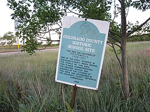 Historical marker commemorating 1909-1937 school
 -
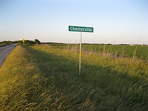 Sign on FM 2764 looking northeast across fields


References
- ^ Google (June 3, 2013). "Chesterville, Texas" (Map). Google Maps. Google. Retrieved June 3, 2013.
- ^ Carroll, Jeff. "Handbook of Texas: CHESTERVILLE, TEXAS". Texas State Historical Association. Retrieved April 29, 2013.
See also
- "Texas Escapes: Chesterville, Texas". TexasEscapes.com - Blueprints for Travel, LLC. 2010. Retrieved April 30, 2013.
Municipalities and communities of
Colorado County, Texas, United States | ||
|---|---|---|
| Cities |  | |
| CDP | ||
|
Other communities | ||
| Ghost towns | ||
 | This article about a location in Colorado County, Texas is a stub. You can help Wikipedia by expanding it. |
Chesterville, Texas | |
|---|---|
Chesterville Location within the state of Texas | |
| Coordinates: 29°36′36″N 96°12′27″W / 29.61000°N 96.20750°W | |
| Country | United States |
| State | Texas |
| County | Colorado |
| Elevation | 156 ft (48 m) |
| Time zone | UTC-6 ( Central (CST)) |
| • Summer ( DST) | UTC-5 (CDT) |
| ZIP code | 77435 |
| Area code | 979 |
Chesterville is an unincorporated community in eastern Colorado County, in the U.S. state of Texas. It is located in a farming region northeast of Eagle Lake, at the junction of Farm to Market Road 1093 (FM 1093) and Farm to Market Road 2764 (FM 2764). A large grain storage facility is a significant landmark in the area.
Geography
The small community of Chesterville is situated in extreme eastern Colorado County. In fact, FM 2764 runs along the boundary line with Wharton County except in the short distance where it curves north to meet FM 1093 at right angles at Chesterville. The Chesterville Cemetery is located on County Road 262 about 0.6 miles (1.0 km) to the southeast. Middle Bernard Creek flows to the east of the community. Eagle Lake is 6.5 miles (10.5 km) to the west-southwest on FM 1093 while Wallis is 9.0 miles (14.5 km) to the east-northeast on the same highway. FM 2764 heads 4.4 miles (7.1 km) southwest to connect with U.S. Route 90 Alternate near Lissie. [1]
History
In 1894, John Linderholm of Chicago bought 60,000 acres of land in the area for his Southern Texas Colonization Company. Linderholm's efforts to promote settlement were successful and people from the Midwest flocked to the area. In 1895 a post office was set up and the town was named after the land surveyor William P. Chester. Soon there were between 150 and 200 persons living in a community served by a school, 20 businesses and several churches. However, it was soon found that the land was more suited to large-scale rice growing and cattle-raising than for small-scale farming. By 1914 the population fell to 75 and shrank further to 25 by 1933. The post office closed in 1950 while the population of 25 held steady through 1966. One rice business remained in the area by the 1980s. About 50 persons lived in the area in 2000. [2]
-
Sign on FM 1093 with grain elevator as backdrop
-
Historical marker commemorating 1909-1937 school
-
Sign on FM 2764 looking northeast across fields
References
- ^ Google (June 3, 2013). "Chesterville, Texas" (Map). Google Maps. Google. Retrieved June 3, 2013.
- ^ Carroll, Jeff. "Handbook of Texas: CHESTERVILLE, TEXAS". Texas State Historical Association. Retrieved April 29, 2013.
See also
- "Texas Escapes: Chesterville, Texas". TexasEscapes.com - Blueprints for Travel, LLC. 2010. Retrieved April 30, 2013.
Municipalities and communities of
Colorado County, Texas, United States | ||
|---|---|---|
| Cities | | |
| CDP | ||
|
Other communities | ||
| Ghost towns | ||
|
| This article about a location in Colorado County, Texas is a stub. You can help Wikipedia by expanding it. |