Photos • Location
Chehel Amiran
چهل اميران | |
|---|---|
village | |
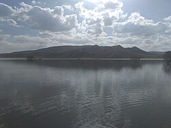
 The image of the village of Chehl Amiran Cheng Almas disappearing under the water of Talwar Dam on May 5, 2018 | |
| Coordinates: 35°43′47″N 47°53′07″E / 35.72972°N 47.88528°E | |
| Country | |
| Province | Kurdistan |
| County | Bijar |
| Bakhsh | Chang Almas |
| Rural District | Babarashani |
| Population (2006) | |
| • Total | 120 |
| Time zone | UTC+3:30 ( IRST) |
| • Summer ( DST) | UTC+4:30 ( IRDT) |
Chehel Amiran ( Persian: چهل اميران, also Romanized as Chehel Amīrān; also known as Chahlamīzan and Chehlān Mīzān) [1] is a village in Babarashani Rural District, Chang Almas District, Bijar County, Kurdistan Province, Iran. [2] In 2006, its population was 120, in 27 families. [3] The village is populated by Kurds. [4]
References
- ^ Chehel Amiran can be found at GEOnet Names Server, at this link, by opening the Advanced Search box, entering "-3058249" in the "Unique Feature Id" form, and clicking on "Search Database".
- ^ "درگاه ملی آمار > نقشه دهستانها > سال ۱۳۹۰ > كردستان". www.amar.org.ir. Statistical Centre of Iran. Retrieved 2019-09-14.
- ^ "Census of the Islamic Republic of Iran, 1385 (2006)" (Excel). Statistical Center of Iran. Archived from the original on 2011-09-20.
- ^ "Language distribution: Kordestan Province". Iran Atlas. 2015. Archived from the original on 2017-12-04. Retrieved 22 March 2021.
Chehel Amiran
چهل اميران | |
|---|---|
village | |
 The image of the village of Chehl Amiran Cheng Almas disappearing under the water of Talwar Dam on May 5, 2018 | |
| Coordinates: 35°43′47″N 47°53′07″E / 35.72972°N 47.88528°E | |
| Country | |
| Province | Kurdistan |
| County | Bijar |
| Bakhsh | Chang Almas |
| Rural District | Babarashani |
| Population (2006) | |
| • Total | 120 |
| Time zone | UTC+3:30 ( IRST) |
| • Summer ( DST) | UTC+4:30 ( IRDT) |
Chehel Amiran ( Persian: چهل اميران, also Romanized as Chehel Amīrān; also known as Chahlamīzan and Chehlān Mīzān) [1] is a village in Babarashani Rural District, Chang Almas District, Bijar County, Kurdistan Province, Iran. [2] In 2006, its population was 120, in 27 families. [3] The village is populated by Kurds. [4]
References
- ^ Chehel Amiran can be found at GEOnet Names Server, at this link, by opening the Advanced Search box, entering "-3058249" in the "Unique Feature Id" form, and clicking on "Search Database".
- ^ "درگاه ملی آمار > نقشه دهستانها > سال ۱۳۹۰ > كردستان". www.amar.org.ir. Statistical Centre of Iran. Retrieved 2019-09-14.
- ^ "Census of the Islamic Republic of Iran, 1385 (2006)" (Excel). Statistical Center of Iran. Archived from the original on 2011-09-20.
- ^ "Language distribution: Kordestan Province". Iran Atlas. 2015. Archived from the original on 2017-12-04. Retrieved 22 March 2021.
