Photos • Location
Chechar District
دائرة ششار | |
|---|---|
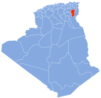
 Map of Algeria highlighting Khenchela Province | |
| Coordinates: 35°2′14″N 7°0′35.1″E / 35.03722°N 7.009750°E | |
| Country | Algeria |
| Province | Khenchela |
| District seat | Chechar |
| Area | |
| • Total | 2,066 km2 (798 sq mi) |
| Population (1998) | |
| • Total | 33,812 |
| • Density | 16/km2 (42/sq mi) |
| Time zone | UTC+01 ( CET) |
| Municipalities | 4 |
Chechar (
Arabic: ششار;
Tifinagh:
![]() ) is a
district in
Khenchela
Province, Algeria. It was named after its capital,
Chechar.
) is a
district in
Khenchela
Province, Algeria. It was named after its capital,
Chechar.
Municipalities
The district is further divided into four municipalities:
- Chechar
- Djellal
- Khirane
- El Oueldja
References
Chechar District
دائرة ششار | |
|---|---|
 Map of Algeria highlighting Khenchela Province | |
| Coordinates: 35°2′14″N 7°0′35.1″E / 35.03722°N 7.009750°E | |
| Country | Algeria |
| Province | Khenchela |
| District seat | Chechar |
| Area | |
| • Total | 2,066 km2 (798 sq mi) |
| Population (1998) | |
| • Total | 33,812 |
| • Density | 16/km2 (42/sq mi) |
| Time zone | UTC+01 ( CET) |
| Municipalities | 4 |
Chechar (
Arabic: ششار;
Tifinagh:
![]() ) is a
district in
Khenchela
Province, Algeria. It was named after its capital,
Chechar.
) is a
district in
Khenchela
Province, Algeria. It was named after its capital,
Chechar.
Municipalities
The district is further divided into four municipalities:
- Chechar
- Djellal
- Khirane
- El Oueldja
