Chandlers Chapel, Kentucky | |
|---|---|
 Chandlers Chapel Location in Kentucky  Chandlers Chapel Location in the United States | |
| Coordinates: 36°56′57″N 86°47′35″W / 36.94917°N 86.79306°W | |
| Country | United States |
| State | Kentucky |
| County | Logan |
| Elevation | 630 ft (190 m) |
| Time zone | UTC-6 ( Central (CST)) |
| • Summer ( DST) | UTC-5 (CST) |
| GNIS feature ID | 489328 [1] |
Chandlers Chapel is an unincorporated community located in Logan County, Kentucky, United States.
The David Sawyer House, built in 1814 near Chandlers Chapel, has been listed on the National Register of Historic Places. [2]
The area was impacted by an EF3 tornado just after midnight on December 11, 2021, with the Methodist Church and several homes being heavily damaged. [3]
References
- ^ U.S. Geological Survey Geographic Names Information System: Chandlers Chapel
- ^ "National Register Information System". National Register of Historic Places. National Park Service. July 9, 2010.
- ^ "NWS Damage Survey for 12/11/21 Tornado Event". Iowa Environmental Mesonet. National Weather Service Weather Forecast Office in Louisville, Kentucky. December 17, 2021. Retrieved December 18, 2021.
Municipalities and communities of
Logan County, Kentucky, United States | ||
|---|---|---|
| Cities | 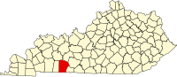 | |
| CDP | ||
|
Other unincorporated communities | ||
| Footnotes | ‡This populated place also has portions in an adjacent county or counties | |
|
| This Logan County, Kentucky state location article is a stub. You can help Wikipedia by expanding it. |
Chandlers Chapel, Kentucky | |
|---|---|
Chandlers Chapel Location in Kentucky Chandlers Chapel Location in the United States | |
| Coordinates: 36°56′57″N 86°47′35″W / 36.94917°N 86.79306°W | |
| Country | United States |
| State | Kentucky |
| County | Logan |
| Elevation | 630 ft (190 m) |
| Time zone | UTC-6 ( Central (CST)) |
| • Summer ( DST) | UTC-5 (CST) |
| GNIS feature ID | 489328 [1] |
Chandlers Chapel is an unincorporated community located in Logan County, Kentucky, United States.
The David Sawyer House, built in 1814 near Chandlers Chapel, has been listed on the National Register of Historic Places. [2]
The area was impacted by an EF3 tornado just after midnight on December 11, 2021, with the Methodist Church and several homes being heavily damaged. [3]
References
- ^ U.S. Geological Survey Geographic Names Information System: Chandlers Chapel
- ^ "National Register Information System". National Register of Historic Places. National Park Service. July 9, 2010.
- ^ "NWS Damage Survey for 12/11/21 Tornado Event". Iowa Environmental Mesonet. National Weather Service Weather Forecast Office in Louisville, Kentucky. December 17, 2021. Retrieved December 18, 2021.
Municipalities and communities of
Logan County, Kentucky, United States | ||
|---|---|---|
| Cities | | |
| CDP | ||
|
Other unincorporated communities | ||
| Footnotes | ‡This populated place also has portions in an adjacent county or counties | |
|
| This Logan County, Kentucky state location article is a stub. You can help Wikipedia by expanding it. |