Chak No. 291/E.B | |
|---|---|
Village | |
 Chak No. 291/E.B | |
| Coordinates: 30°06′09″N 72°50′47″E / 30.102486°N 72.846297°E | |
| Country | |
| Province |
Punjab |
| Region/Division | Multan |
| District | Vehari District |
| Tehsil | Burewala |
| Union Council | 75 |
| Population | 23,094 |
| Time zone | UTC+5 ( PST) |
| Area code | +92 (0) 67 |
| Website | www.tmaburewala.com |
Chak No. 291/E.B is a village of Burewala, Punjab, Pakistan situated on Jamlera Road. It is located at coordinate 30.102486N 72.846297E about 20 km away from the main city of Burewala. This village is 54 km away from district Vehari, and about 150 km away from its division Multan. It is a quite large village of Burewala Tehsil. It is known as Progressive Village in Tehsil Burewala. Daily, youth of many other villages went here for playing Floodlight Football Matches and also Kabaddi Matches.
As per the national census of 1998 Punjabi language is the main language of Chak No. 291/E.B spoken by 94% population.
- Govt. Boys High School [1] [2]
- Govt. Girls High School [3]
- Govt. Hospital
- Union Council
- Post Office
- Religious Educational Institutions
- Private Schools (3 nos.)
- Jamal Agriculture Corporation
- Floodlight Football Ground
Mostly peoples having agriculture business here which is the backbone of the economy.
turnip, carrot, broad beans, eggplant, tomato, cucumber, onion, garlic, Red Chili, potato, Momordica charantia, pumpkin, white radish and spinach
Mangoes, Oranges, Guava, Watermelon, Lemons, Jamun, Pomegranate, Peaches, Grewia asiatica
-
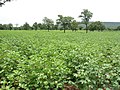 Cotton Fields-کپاس

The village of Chak No. 291/E.B is located in Punjab. The area around the village is a flat, alluvial plain and is ideal for agriculture, with many cotton, wheat and corn fields. There is a canal that cut across the 291/E.B village, providing water from for agriculture. This makes the land very fertile. However, land close to the Sutleg river is usually flooded in the monsoon season.
291/E.B features an arid climate with very hot summers and mild winters. The village witnesses some of the most extreme weather in the country.
| Chak No. 291/E.B | ||||||||||||||||||||||||||||||||||||||||||||||||||||||||||||
|---|---|---|---|---|---|---|---|---|---|---|---|---|---|---|---|---|---|---|---|---|---|---|---|---|---|---|---|---|---|---|---|---|---|---|---|---|---|---|---|---|---|---|---|---|---|---|---|---|---|---|---|---|---|---|---|---|---|---|---|---|
| Climate chart ( explanation) | ||||||||||||||||||||||||||||||||||||||||||||||||||||||||||||
| ||||||||||||||||||||||||||||||||||||||||||||||||||||||||||||
| ||||||||||||||||||||||||||||||||||||||||||||||||||||||||||||
| Climate data for Chak No. 291/E.B | |||||||||||||
|---|---|---|---|---|---|---|---|---|---|---|---|---|---|
| Month | Jan | Feb | Mar | Apr | May | Jun | Jul | Aug | Sep | Oct | Nov | Dec | Year |
| Record high °C (°F) | 28.3 (82.9) |
32.0 (89.6) |
39.0 (102.2) |
45.0 (113.0) |
48.9 (120.0) |
52.0 (125.6) |
52.2 (126.0) |
45.0 (113.0) |
42.5 (108.5) |
40.6 (105.1) |
36.0 (96.8) |
29.0 (84.2) |
52.2 (126.0) |
| Mean daily maximum °C (°F) | 21.0 (69.8) |
23.2 (73.8) |
28.5 (83.3) |
35.5 (95.9) |
40.4 (104.7) |
42.3 (108.1) |
39.2 (102.6) |
38.0 (100.4) |
37.2 (99.0) |
34.6 (94.3) |
28.5 (83.3) |
22.7 (72.9) |
32.6 (90.7) |
| Daily mean °C (°F) | 12.7 (54.9) |
15.4 (59.7) |
21.0 (69.8) |
27.5 (81.5) |
32.4 (90.3) |
35.5 (95.9) |
33.9 (93.0) |
33.0 (91.4) |
31.0 (87.8) |
26.4 (79.5) |
19.7 (67.5) |
14.1 (57.4) |
25.2 (77.4) |
| Mean daily minimum °C (°F) | 4.5 (40.1) |
7.6 (45.7) |
13.5 (56.3) |
19.5 (67.1) |
24.4 (75.9) |
28.6 (83.5) |
28.7 (83.7) |
28.0 (82.4) |
24.9 (76.8) |
18.2 (64.8) |
10.9 (51.6) |
5.5 (41.9) |
17.9 (64.1) |
| Record low °C (°F) | −3.9 (25.0) |
−2.0 (28.4) |
3.3 (37.9) |
9.4 (48.9) |
13.5 (56.3) |
20.0 (68.0) |
21.1 (70.0) |
21.1 (70.0) |
16.7 (62.1) |
8.9 (48.0) |
0.6 (33.1) |
−1.1 (30.0) |
−3.9 (25.0) |
| Average precipitation mm (inches) | 7.2 (0.28) |
9.5 (0.37) |
19.5 (0.77) |
12.9 (0.51) |
9.8 (0.39) |
12.3 (0.48) |
61.3 (2.41) |
32.6 (1.28) |
10.8 (0.43) |
1.7 (0.07) |
2.3 (0.09) |
6.9 (0.27) |
186.8 (7.35) |
| Mean monthly sunshine hours | 222.3 | 211.6 | 250.8 | 273.3 | 293.5 | 266.8 | 265.0 | 277.6 | 277.6 | 274.9 | 255.0 | 229.2 | 3,097.6 |
| Source: NOAA (1961–1990) [4] | |||||||||||||
-
 Block govt boys high school
 -
 Block govt boys high school
 -
 Boys high school (masjid gate)
 -
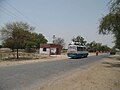 Bus stop
 -
 Bus stop room
 -
 Govt. Girls High School (main gate)
 -
 Govt. Hospital building
 -
 Govt boys high school (main gate)
 -
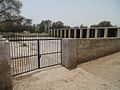
 Hospital main gate
 -
 Jamea Masjid
 -
 Mosque school
 -
 Madrassa Rezae Mustafa
 -
 Union Council
 -
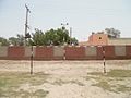
 Sign Boards
 -
 Play ground
 -
 Funeral


.jpg)


.jpg)

.jpg)


- Chak No. 255/E.B Village of Be-Nazeer Bhutto (Late)
- Chak No. 257/E.B
- Chak No. 289/E.B
- Chak No. 299/E.B
- Chak No. 287/E.B
- Chak No. 269/E.B
- Chak No. 293/E.B
- Chak No. 295/E.B
- Chak No. 297/E.B
- Chak No. 281/E.B
- Chak No. 279/E.B
- Chak No. 283/E.B
- Chak No. 275/E.B
- Chak No. 267/E.B
- Chak No. 265/E.B
- Chak No. 203/E.B
- ^ "Government Boys High School CHAK NO 291 EB, SAHUKA, BUREWALA". schoolinglog.com. Retrieved 26 June 2016.
- ^ ":: WELCOME SCHOOL EDUCATION DEPARTMENT ::". schoolportal.punjab.gov.pk. Archived from the original on 24 June 2016. Retrieved 26 June 2016.
- ^ "Government Girls High School 291 EB, SAHUKA, BUREWALA". schoolinglog.com. Retrieved 26 June 2016.
- ^ "Multan Climate Normals 1961–1990". National Oceanic and Atmospheric Administration. Retrieved 16 January 2013.
Chak No. 291/E.B | |
|---|---|
Village | |
Chak No. 291/E.B | |
| Coordinates: 30°06′09″N 72°50′47″E / 30.102486°N 72.846297°E | |
| Country | |
| Province |
Punjab |
| Region/Division | Multan |
| District | Vehari District |
| Tehsil | Burewala |
| Union Council | 75 |
| Population | 23,094 |
| Time zone | UTC+5 ( PST) |
| Area code | +92 (0) 67 |
| Website | www.tmaburewala.com |
Chak No. 291/E.B is a village of Burewala, Punjab, Pakistan situated on Jamlera Road. It is located at coordinate 30.102486N 72.846297E about 20 km away from the main city of Burewala. This village is 54 km away from district Vehari, and about 150 km away from its division Multan. It is a quite large village of Burewala Tehsil. It is known as Progressive Village in Tehsil Burewala. Daily, youth of many other villages went here for playing Floodlight Football Matches and also Kabaddi Matches.
As per the national census of 1998 Punjabi language is the main language of Chak No. 291/E.B spoken by 94% population.
- Govt. Boys High School [1] [2]
- Govt. Girls High School [3]
- Govt. Hospital
- Union Council
- Post Office
- Religious Educational Institutions
- Private Schools (3 nos.)
- Jamal Agriculture Corporation
- Floodlight Football Ground
Mostly peoples having agriculture business here which is the backbone of the economy.
turnip, carrot, broad beans, eggplant, tomato, cucumber, onion, garlic, Red Chili, potato, Momordica charantia, pumpkin, white radish and spinach
Mangoes, Oranges, Guava, Watermelon, Lemons, Jamun, Pomegranate, Peaches, Grewia asiatica
-
Cotton Fields-کپاس
The village of Chak No. 291/E.B is located in Punjab. The area around the village is a flat, alluvial plain and is ideal for agriculture, with many cotton, wheat and corn fields. There is a canal that cut across the 291/E.B village, providing water from for agriculture. This makes the land very fertile. However, land close to the Sutleg river is usually flooded in the monsoon season.
291/E.B features an arid climate with very hot summers and mild winters. The village witnesses some of the most extreme weather in the country.
| Chak No. 291/E.B | ||||||||||||||||||||||||||||||||||||||||||||||||||||||||||||
|---|---|---|---|---|---|---|---|---|---|---|---|---|---|---|---|---|---|---|---|---|---|---|---|---|---|---|---|---|---|---|---|---|---|---|---|---|---|---|---|---|---|---|---|---|---|---|---|---|---|---|---|---|---|---|---|---|---|---|---|---|
| Climate chart ( explanation) | ||||||||||||||||||||||||||||||||||||||||||||||||||||||||||||
| ||||||||||||||||||||||||||||||||||||||||||||||||||||||||||||
| ||||||||||||||||||||||||||||||||||||||||||||||||||||||||||||
| Climate data for Chak No. 291/E.B | |||||||||||||
|---|---|---|---|---|---|---|---|---|---|---|---|---|---|
| Month | Jan | Feb | Mar | Apr | May | Jun | Jul | Aug | Sep | Oct | Nov | Dec | Year |
| Record high °C (°F) | 28.3 (82.9) |
32.0 (89.6) |
39.0 (102.2) |
45.0 (113.0) |
48.9 (120.0) |
52.0 (125.6) |
52.2 (126.0) |
45.0 (113.0) |
42.5 (108.5) |
40.6 (105.1) |
36.0 (96.8) |
29.0 (84.2) |
52.2 (126.0) |
| Mean daily maximum °C (°F) | 21.0 (69.8) |
23.2 (73.8) |
28.5 (83.3) |
35.5 (95.9) |
40.4 (104.7) |
42.3 (108.1) |
39.2 (102.6) |
38.0 (100.4) |
37.2 (99.0) |
34.6 (94.3) |
28.5 (83.3) |
22.7 (72.9) |
32.6 (90.7) |
| Daily mean °C (°F) | 12.7 (54.9) |
15.4 (59.7) |
21.0 (69.8) |
27.5 (81.5) |
32.4 (90.3) |
35.5 (95.9) |
33.9 (93.0) |
33.0 (91.4) |
31.0 (87.8) |
26.4 (79.5) |
19.7 (67.5) |
14.1 (57.4) |
25.2 (77.4) |
| Mean daily minimum °C (°F) | 4.5 (40.1) |
7.6 (45.7) |
13.5 (56.3) |
19.5 (67.1) |
24.4 (75.9) |
28.6 (83.5) |
28.7 (83.7) |
28.0 (82.4) |
24.9 (76.8) |
18.2 (64.8) |
10.9 (51.6) |
5.5 (41.9) |
17.9 (64.1) |
| Record low °C (°F) | −3.9 (25.0) |
−2.0 (28.4) |
3.3 (37.9) |
9.4 (48.9) |
13.5 (56.3) |
20.0 (68.0) |
21.1 (70.0) |
21.1 (70.0) |
16.7 (62.1) |
8.9 (48.0) |
0.6 (33.1) |
−1.1 (30.0) |
−3.9 (25.0) |
| Average precipitation mm (inches) | 7.2 (0.28) |
9.5 (0.37) |
19.5 (0.77) |
12.9 (0.51) |
9.8 (0.39) |
12.3 (0.48) |
61.3 (2.41) |
32.6 (1.28) |
10.8 (0.43) |
1.7 (0.07) |
2.3 (0.09) |
6.9 (0.27) |
186.8 (7.35) |
| Mean monthly sunshine hours | 222.3 | 211.6 | 250.8 | 273.3 | 293.5 | 266.8 | 265.0 | 277.6 | 277.6 | 274.9 | 255.0 | 229.2 | 3,097.6 |
| Source: NOAA (1961–1990) [4] | |||||||||||||
-
Block govt boys high school
-
Block govt boys high school
-
Boys high school (masjid gate)
-
Bus stop
-
Bus stop room
-
Govt. Girls High School (main gate)
-
Govt. Hospital building
-
Govt boys high school (main gate)
-
Hospital main gate
-
Jamea Masjid
-
Mosque school
-
Madrassa Rezae Mustafa
-
Union Council
-
Sign Boards
-
Play ground
-
Funeral
- Chak No. 255/E.B Village of Be-Nazeer Bhutto (Late)
- Chak No. 257/E.B
- Chak No. 289/E.B
- Chak No. 299/E.B
- Chak No. 287/E.B
- Chak No. 269/E.B
- Chak No. 293/E.B
- Chak No. 295/E.B
- Chak No. 297/E.B
- Chak No. 281/E.B
- Chak No. 279/E.B
- Chak No. 283/E.B
- Chak No. 275/E.B
- Chak No. 267/E.B
- Chak No. 265/E.B
- Chak No. 203/E.B
- ^ "Government Boys High School CHAK NO 291 EB, SAHUKA, BUREWALA". schoolinglog.com. Retrieved 26 June 2016.
- ^ ":: WELCOME SCHOOL EDUCATION DEPARTMENT ::". schoolportal.punjab.gov.pk. Archived from the original on 24 June 2016. Retrieved 26 June 2016.
- ^ "Government Girls High School 291 EB, SAHUKA, BUREWALA". schoolinglog.com. Retrieved 26 June 2016.
- ^ "Multan Climate Normals 1961–1990". National Oceanic and Atmospheric Administration. Retrieved 16 January 2013.