Photos • Location

| Chüemettler | |
|---|---|
 | |
| Highest point | |
| Elevation | 1,703 m (5,587 ft) |
| Prominence | 99 m (325 ft) [1] |
| Parent peak | Speer and Federispitz |
| Coordinates | 47°10′47″N 9°5′46″E / 47.17972°N 9.09611°E |
| Geography | |
| Location | St. Gallen, Switzerland |
| Parent range | Appenzell Alps |
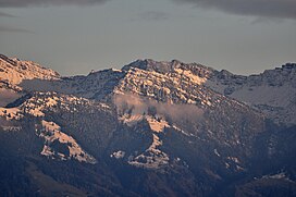
The Chüemettler (1,703 metres (5,587 ft)) is a mountain of the Appenzell Alps in the canton of St. Gallen, overlooking Obersee ( Lake Zurich). It lies west of the Speer and north of the Federispitz mountains. Chüe literally means cows in Swiss-German language, Mettler is a family name, respectively a term used as name of several local areas.
References
External links
Wikimedia Commons has media related to
Chüemettler.
| Chüemettler | |
|---|---|
 | |
| Highest point | |
| Elevation | 1,703 m (5,587 ft) |
| Prominence | 99 m (325 ft) [1] |
| Parent peak | Speer and Federispitz |
| Coordinates | 47°10′47″N 9°5′46″E / 47.17972°N 9.09611°E |
| Geography | |
| Location | St. Gallen, Switzerland |
| Parent range | Appenzell Alps |
The Chüemettler (1,703 metres (5,587 ft)) is a mountain of the Appenzell Alps in the canton of St. Gallen, overlooking Obersee ( Lake Zurich). It lies west of the Speer and north of the Federispitz mountains. Chüe literally means cows in Swiss-German language, Mettler is a family name, respectively a term used as name of several local areas.
References
External links
Wikimedia Commons has media related to
Chüemettler.