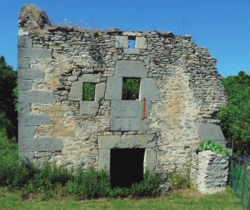
Cerca de Villaño | |
|---|---|
 A ruined house in the exclave | |
| Coordinates: 42°58′09″N 3°07′21″W / 42.96917°N 3.12250°W | |
| Country | Spain |
| Autonomous community | Basque Country |
| Province | Biscay |
| Comarca | Arratia-Nerbioi |
| Municipality | Orduña |
| Area | |
| • Total | 0.36 ha (0.89 acres) |
| Elevation | 807 m (2,648 ft) |
|
| |
The Cerca de Villaño ( Basque: Villañoko esparrua [2]) is a small exclave belonging to Orduña, itself an exclave of Biscay (a province of the Basque Country, Spain). It is located in Villaño, a hamlet in Valle de Losa, Burgos. Its area and limits aren't known with certainty, and due to its small size and obscurity it isn't shown in most maps. [3]
The early history of the enclave is unclear, but it was part of Orduña by the early sixteenth century. [1] The municipal authorities of Orduña used to visit the exclave regularly until 1951 in order to check the border markers. [4] Around the same time, in 1950, the few inhabitants of the enclave were registered as inhabitants of Valle de Losa, and the exclave fell into obscurity. [5]
In 2015, a member of the Juntas Generales of Biscay requested the Biscayan government to reaffirm the exclave's status as part of Biscay, but his proposal was rejected. [6] In 2022, the municipality of Orduña started the procedures to survey the exclave and include it in its urban planning documentation. [7]
References
- ^ a b García Galán, Nicolás (2017). "Territorios separados en España: origen y situación actual" (PDF). Espacio, Tiempo y Forma. Serie VI Geografía (in Spanish) (10): 151–153. doi: 10.5944/etfvi.10.2017.18696. ISSN 1130-2968. Retrieved 12 May 2022.
- ^ "Villañoko Esparrua - Places - EODA". Euskaltzaindia. Retrieved 12 May 2022.
- ^ Errazti, Izaskun (14 December 2017). "El cachito de Bizkaia que está en Burgos y no sale en los mapas". El Correo (in Spanish). Retrieved 12 May 2022.
- ^ Garayo Urruela, Jesús Mª (1994). "La Cerca de Villaño: enclavado del municipio de Orduña en la provincia de Burgos". Boletín de la Real Sociedad Bascongada de Amigos del País (in Spanish) (1): 197–208. Retrieved 12 May 2022.
- ^ "Orduña investiga su jurisdicción sobre La Cerca de Villaño". Diario de Burgos (in Spanish). 25 March 2022. Retrieved 12 May 2022.
- ^ "Los grupos junteros se citan en la próxima legislatura para eliminar las cesantías de los altos cargos forales". Europa Press (in Spanish). Bilbao. 30 March 2015. Retrieved 12 May 2022.
- ^ Loza, Gonzalo (21 March 2022). "La 'cerca de Villaño' en medio de Burgos, más cerca de ser oficialmente Bizkaia". Cadena SER (in Spanish). Retrieved 12 May 2022.
Cerca de Villaño | |
|---|---|
 A ruined house in the exclave | |
| Coordinates: 42°58′09″N 3°07′21″W / 42.96917°N 3.12250°W | |
| Country | Spain |
| Autonomous community | Basque Country |
| Province | Biscay |
| Comarca | Arratia-Nerbioi |
| Municipality | Orduña |
| Area | |
| • Total | 0.36 ha (0.89 acres) |
| Elevation | 807 m (2,648 ft) |
|
| |
The Cerca de Villaño ( Basque: Villañoko esparrua [2]) is a small exclave belonging to Orduña, itself an exclave of Biscay (a province of the Basque Country, Spain). It is located in Villaño, a hamlet in Valle de Losa, Burgos. Its area and limits aren't known with certainty, and due to its small size and obscurity it isn't shown in most maps. [3]
The early history of the enclave is unclear, but it was part of Orduña by the early sixteenth century. [1] The municipal authorities of Orduña used to visit the exclave regularly until 1951 in order to check the border markers. [4] Around the same time, in 1950, the few inhabitants of the enclave were registered as inhabitants of Valle de Losa, and the exclave fell into obscurity. [5]
In 2015, a member of the Juntas Generales of Biscay requested the Biscayan government to reaffirm the exclave's status as part of Biscay, but his proposal was rejected. [6] In 2022, the municipality of Orduña started the procedures to survey the exclave and include it in its urban planning documentation. [7]
References
- ^ a b García Galán, Nicolás (2017). "Territorios separados en España: origen y situación actual" (PDF). Espacio, Tiempo y Forma. Serie VI Geografía (in Spanish) (10): 151–153. doi: 10.5944/etfvi.10.2017.18696. ISSN 1130-2968. Retrieved 12 May 2022.
- ^ "Villañoko Esparrua - Places - EODA". Euskaltzaindia. Retrieved 12 May 2022.
- ^ Errazti, Izaskun (14 December 2017). "El cachito de Bizkaia que está en Burgos y no sale en los mapas". El Correo (in Spanish). Retrieved 12 May 2022.
- ^ Garayo Urruela, Jesús Mª (1994). "La Cerca de Villaño: enclavado del municipio de Orduña en la provincia de Burgos". Boletín de la Real Sociedad Bascongada de Amigos del País (in Spanish) (1): 197–208. Retrieved 12 May 2022.
- ^ "Orduña investiga su jurisdicción sobre La Cerca de Villaño". Diario de Burgos (in Spanish). 25 March 2022. Retrieved 12 May 2022.
- ^ "Los grupos junteros se citan en la próxima legislatura para eliminar las cesantías de los altos cargos forales". Europa Press (in Spanish). Bilbao. 30 March 2015. Retrieved 12 May 2022.
- ^ Loza, Gonzalo (21 March 2022). "La 'cerca de Villaño' en medio de Burgos, más cerca de ser oficialmente Bizkaia". Cadena SER (in Spanish). Retrieved 12 May 2022.
