Photos • Location

Ceadîr-Lunga Airport | |||||||||||
|---|---|---|---|---|---|---|---|---|---|---|---|
| Summary | |||||||||||
| Airport type | Public | ||||||||||
| Location | Ceadîr-Lunga, Moldova | ||||||||||
| Elevation AMSL | 587 ft / 179 m | ||||||||||
| Coordinates | 46°02′05.98″N 028°51′06.64″E / 46.0349944°N 28.8518444°E | ||||||||||
| Runways | |||||||||||
| |||||||||||

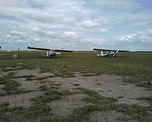
Ceadîr-Lunga Airport ( ICAO: LUCL) is located in Ceadîr-Lunga, Gagauzia, Moldova, 3 km (1.85 mi) south-east of the city centre.
The airport closed.
|
| This article about a European airport is a stub. You can help Wikipedia by expanding it. |
|
| This article about transport in Moldova is a stub. You can help Wikipedia by expanding it. |
Ceadîr-Lunga Airport | |||||||||||
|---|---|---|---|---|---|---|---|---|---|---|---|
| Summary | |||||||||||
| Airport type | Public | ||||||||||
| Location | Ceadîr-Lunga, Moldova | ||||||||||
| Elevation AMSL | 587 ft / 179 m | ||||||||||
| Coordinates | 46°02′05.98″N 028°51′06.64″E / 46.0349944°N 28.8518444°E | ||||||||||
| Runways | |||||||||||
| |||||||||||
Ceadîr-Lunga Airport ( ICAO: LUCL) is located in Ceadîr-Lunga, Gagauzia, Moldova, 3 km (1.85 mi) south-east of the city centre.
The airport closed.
|
| This article about a European airport is a stub. You can help Wikipedia by expanding it. |
|
| This article about transport in Moldova is a stub. You can help Wikipedia by expanding it. |