Caron is a hamlet in Saskatchewan, Canada, located on the south side of the Trans-Canada Highway, 26 kilometres (16 mi) west of Moose Jaw along the course of Thunder Creek.
Caron was originally a Canadian Pacific Railway (CPR) siding in 1882, named after Sir Adolphe Caron, then Canadian Minister for Militia and Defence.
Although associated with the BCATP, RCAF Station Caron was located 3 km (1.9 mi) north-east of Caron. The former station is now the community of Caronport (the name "Caronport" combines "Caron" and "airport"). There is no trace of the former runways or taxiways and the airfield is closed to all traffic. Some of the buildings are now the property of the Briercrest Family of Schools.
Demographics
In the 2021 Census of Population conducted by Statistics Canada, Caron had a population of 199 living in 70 of its 79 total private dwellings, a change of 22.1% from its 2016 population of 163. With a land area of 0.66 km2 (0.25 sq mi), it had a population density of 301.5/km2 (780.9/sq mi) in 2021. [1]
Gallery
-
 Memorial for the No. 33 Flying School (BCATP), Caronport, SK.
 -
 Close-up of the Bronze plaque, Caronport, SK.
 -
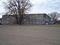 Original aircraft hangar, No. 33 EFTS, Caronport, SK. (Since demolished)


See also
References
- ^ "Population and dwelling counts: Canada and designated places". Statistics Canada. February 9, 2022. Retrieved August 31, 2022.
50°27′31″N 105°52′23″W / 50.45861°N 105.87306°W
|
| This article about a location in the Census Division No. 7 of Saskatchewan is a stub. You can help Wikipedia by expanding it. |
Caron is a hamlet in Saskatchewan, Canada, located on the south side of the Trans-Canada Highway, 26 kilometres (16 mi) west of Moose Jaw along the course of Thunder Creek.
Caron was originally a Canadian Pacific Railway (CPR) siding in 1882, named after Sir Adolphe Caron, then Canadian Minister for Militia and Defence.
Although associated with the BCATP, RCAF Station Caron was located 3 km (1.9 mi) north-east of Caron. The former station is now the community of Caronport (the name "Caronport" combines "Caron" and "airport"). There is no trace of the former runways or taxiways and the airfield is closed to all traffic. Some of the buildings are now the property of the Briercrest Family of Schools.
Demographics
In the 2021 Census of Population conducted by Statistics Canada, Caron had a population of 199 living in 70 of its 79 total private dwellings, a change of 22.1% from its 2016 population of 163. With a land area of 0.66 km2 (0.25 sq mi), it had a population density of 301.5/km2 (780.9/sq mi) in 2021. [1]
Gallery
-
Memorial for the No. 33 Flying School (BCATP), Caronport, SK.
-
Close-up of the Bronze plaque, Caronport, SK.
-
Original aircraft hangar, No. 33 EFTS, Caronport, SK. (Since demolished)
See also
References
- ^ "Population and dwelling counts: Canada and designated places". Statistics Canada. February 9, 2022. Retrieved August 31, 2022.
| Cities |  | ||||
|---|---|---|---|---|---|
| Towns | |||||
| Villages | |||||
| Resort villages | |||||
| Rural municipalities | |||||
| Unincorporated communities |
| ||||
50°27′31″N 105°52′23″W / 50.45861°N 105.87306°W
|
| This article about a location in the Census Division No. 7 of Saskatchewan is a stub. You can help Wikipedia by expanding it. |