Carham | |
|---|---|
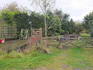
 The former westbound platform of the station in 2020 | |
| General information | |
| Location |
Roxburghshire,
Scottish Borders Scotland |
| Coordinates | 55°37′37″N 2°20′02″W / 55.62683°N 2.33376°W |
| Grid reference | NT792372 |
| Platforms | 2 |
| Other information | |
| Status | Disused |
| History | |
| Original company | York, Newcastle and Berwick Railway |
| Pre-grouping | North Eastern Railway |
| Post-grouping |
LNER British Railways (Scottish Region) |
| Key dates | |
| 27 July 1849 | Opened |
| 4 July 1955 | Closed to passengers |
| 18 May 1964 | Closed to goods |
Carham railway station was located in the historic county of Roxburghshire, Scotland, from 1849 to 1964 on the Kelso Branch. It served the village of Carham in Northumberland, England.
The station opened on 27 July 1849 by the York, Newcastle and Berwick Railway. It was situated on a minor lane on the B6350. Even though the station was named Carham, it was located in Roxburghshire, being 3 quarters of a mile from the village. To the east was the goods yard and Shidlaw Tile Works, which was served by a siding near the two limekilns to the south. The works closed in 1898. A signal box was built in 1880 but it was replaced by another in 1903 to the southwest of the level crossing. The final passenger train called at the station on 2 July 1955 and passenger trains officially ceased two days later. It closed to goods on 18 May 1964. [1]
- ^ "Disused Stations: Carham Station". Disused Stations. Retrieved 19 December 2020.
| Preceding station | Disused railways | Following station | ||
|---|---|---|---|---|
|
Sprouston Line and station closed |
York, Newcastle and Berwick Railway Kelso Branch |
Sunilaws Line and station closed |
Carham | |
|---|---|
 The former westbound platform of the station in 2020 | |
| General information | |
| Location |
Roxburghshire,
Scottish Borders Scotland |
| Coordinates | 55°37′37″N 2°20′02″W / 55.62683°N 2.33376°W |
| Grid reference | NT792372 |
| Platforms | 2 |
| Other information | |
| Status | Disused |
| History | |
| Original company | York, Newcastle and Berwick Railway |
| Pre-grouping | North Eastern Railway |
| Post-grouping |
LNER British Railways (Scottish Region) |
| Key dates | |
| 27 July 1849 | Opened |
| 4 July 1955 | Closed to passengers |
| 18 May 1964 | Closed to goods |
Carham railway station was located in the historic county of Roxburghshire, Scotland, from 1849 to 1964 on the Kelso Branch. It served the village of Carham in Northumberland, England.
The station opened on 27 July 1849 by the York, Newcastle and Berwick Railway. It was situated on a minor lane on the B6350. Even though the station was named Carham, it was located in Roxburghshire, being 3 quarters of a mile from the village. To the east was the goods yard and Shidlaw Tile Works, which was served by a siding near the two limekilns to the south. The works closed in 1898. A signal box was built in 1880 but it was replaced by another in 1903 to the southwest of the level crossing. The final passenger train called at the station on 2 July 1955 and passenger trains officially ceased two days later. It closed to goods on 18 May 1964. [1]
- ^ "Disused Stations: Carham Station". Disused Stations. Retrieved 19 December 2020.
| Preceding station | Disused railways | Following station | ||
|---|---|---|---|---|
|
Sprouston Line and station closed |
York, Newcastle and Berwick Railway Kelso Branch |
Sunilaws Line and station closed |