Photos • Location

Location within the municipality

Carapito | |
|---|---|
 Carapito Location in Portugal | |
| Coordinates: 40°45′50″N 7°27′50″W / 40.764°N 7.464°W | |
| Country | |
| Region | Centro |
| Intermunic. comm. | Viseu Dão Lafões |
| District | Guarda |
| Municipality | Aguiar da Beira |
| Area | |
| • Total | 17.26 km2 (6.66 sq mi) |
| Population (2011) | |
| • Total | 442 |
| • Density | 26/km2 (66/sq mi) |
| Time zone | UTC±00:00 ( WET) |
| • Summer ( DST) | UTC+01:00 ( WEST) |

Carapito is a freguesia in Aguiar da Beira Municipality, Guarda District, Portugal. [1] The population in 2011 was 442, [2] in an area of 17.26 km2. [3] The Dolmen of Carapito I is located in this freguesia.
-
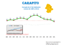 Population from 1864 to 2011
 -
 Population variation from 1864 to 2011


- ^ "Freguesia de Carapito". cm-aguiardabeira.pt (in Portuguese). Município de Aguiar da Beira. Retrieved 5 February 2014.
- ^ Instituto Nacional de Estatística
- ^ "Áreas das freguesias, concelhos, distritos e país". Archived from the original on 2018-11-05. Retrieved 2018-11-05.
|
| This Guarda location article is a stub. You can help Wikipedia by expanding it. |
Carapito | |
|---|---|
Carapito Location in Portugal | |
| Coordinates: 40°45′50″N 7°27′50″W / 40.764°N 7.464°W | |
| Country | |
| Region | Centro |
| Intermunic. comm. | Viseu Dão Lafões |
| District | Guarda |
| Municipality | Aguiar da Beira |
| Area | |
| • Total | 17.26 km2 (6.66 sq mi) |
| Population (2011) | |
| • Total | 442 |
| • Density | 26/km2 (66/sq mi) |
| Time zone | UTC±00:00 ( WET) |
| • Summer ( DST) | UTC+01:00 ( WEST) |
Carapito is a freguesia in Aguiar da Beira Municipality, Guarda District, Portugal. [1] The population in 2011 was 442, [2] in an area of 17.26 km2. [3] The Dolmen of Carapito I is located in this freguesia.
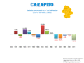
-
Population from 1864 to 2011
-
Population variation from 1864 to 2011
- ^ "Freguesia de Carapito". cm-aguiardabeira.pt (in Portuguese). Município de Aguiar da Beira. Retrieved 5 February 2014.
- ^ Instituto Nacional de Estatística
- ^ "Áreas das freguesias, concelhos, distritos e país". Archived from the original on 2018-11-05. Retrieved 2018-11-05.
|
| This Guarda location article is a stub. You can help Wikipedia by expanding it. |