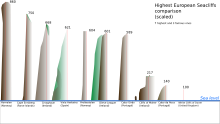

Cape Enniberg is a cliff located on the Island of Viðoy. At 754 metres (2,474 ft) high, it is one of the highest promontories in the world. [1]
Enniberg is the northernmost point of the Faroe Islands. [1] At the southern foot of the nearby 844-metre-high (2,769 ft) mountain, Villingadalsfjall, lies the town of Viðareiði. In summer, boat trips run to Cape Enniberg, which is also the site of an important bird colony.

See also
References
- ^ a b "To the Raw Cliffs". visitfaroeislands.com. Archived from the original on 17 November 2015. Retrieved 13 November 2015.
External links
62°23′N 6°34′W / 62.383°N 6.567°W


Cape Enniberg is a cliff located on the Island of Viðoy. At 754 metres (2,474 ft) high, it is one of the highest promontories in the world. [1]
Enniberg is the northernmost point of the Faroe Islands. [1] At the southern foot of the nearby 844-metre-high (2,769 ft) mountain, Villingadalsfjall, lies the town of Viðareiði. In summer, boat trips run to Cape Enniberg, which is also the site of an important bird colony.

See also
References
- ^ a b "To the Raw Cliffs". visitfaroeislands.com. Archived from the original on 17 November 2015. Retrieved 13 November 2015.
External links
62°23′N 6°34′W / 62.383°N 6.567°W