| Cape Borda South Australia | |||||||||||||||
|---|---|---|---|---|---|---|---|---|---|---|---|---|---|---|---|
 Cape Borda Lighthouse | |||||||||||||||
 Cape Borda | |||||||||||||||
| Coordinates | 35°45′10″S 136°35′36″E / 35.752910°S 136.593390°E | ||||||||||||||
| Population | 10 ( 2016 census) [2] | ||||||||||||||
| Established | 2002 [1] | ||||||||||||||
| Postcode(s) | 5223 [3] | ||||||||||||||
| Time zone | ACST ( UTC+9:30) | ||||||||||||||
| • Summer ( DST) | ACST ( UTC+10:30) | ||||||||||||||
| Location | |||||||||||||||
| LGA(s) | Kangaroo Island Council [1] | ||||||||||||||
| Region | Fleurieu and Kangaroo Island [4] | ||||||||||||||
| County | Carnarvon [1] | ||||||||||||||
| State electorate(s) | Mawson [5] | ||||||||||||||
| Federal division(s) | Mayo [6] | ||||||||||||||
| |||||||||||||||
| |||||||||||||||
| Footnotes | Distances
[3]
[1] Coordinates [1] Climate [7] Adjoining localities [1] | ||||||||||||||
Cape Borda is a locality in the Australian state of South Australia located on Kangaroo Island about 192 kilometres (119 miles) south-west of the state capital of Adelaide. [3]
Its boundaries were created in 2002 in respect to “the long established name” which is reported to be derived from the navigation aid within its boundaries - the Cape Borda Lightstation. [1]
The major land uses within the locality includes conservation and primary production with the former land use including the following protected areas - the Flinders Chase National Park, the Ravine des Casoars Wilderness Protection Area and the Cape Torrens Wilderness Protection Area. [8] [1] Part of the southern boundary of Cape Borda is formed by the Playford Highway. [1]
The locality includes the three following state heritage places - Harveys Return Cemetery, the Cape Borda Lighthouse and the Harveys Return Landing Site. [9] [10] [11]
Cape Borda is located within the federal division of Mayo, the state electoral district of Mawson and the local government area of the Kangaroo Island Council. [6] [5] [1]
-
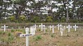 Harvey's Return cemetery
 -
 Harvey's Return plaque


References
- ^ a b c d e f g h i j "Search result for "Cape Borda (Locality Bounded)" (Record no SA0050434 ) with the following layers being selected - "Suburbs and Localities", "Local Government Areas" and "Hundreds"". Department of Planning, Transport and Infrastructure. Archived from the original on 12 October 2016. Retrieved 8 March 2016.
- ^ Australian Bureau of Statistics (27 June 2017). "Cape Borda". 2016 Census QuickStats. Retrieved 12 February 2018.
- ^ a b c "Cape Borda, South Australia (Postcode)". postcodes-australia.com. Retrieved 8 March 2016.
- ^ "Fleurieu and Kangaroo Island SA Government region" (PDF). The Government of South Australia. Archived from the original (PDF) on 21 March 2019. Retrieved 9 September 2016.
- ^ a b Mawson (Map). Electoral District Boundaries Commission. 2016. Retrieved 2 March 2018.
- ^ a b "Federal electoral division of Mayo, boundary gazetted 16 December 2011" (PDF). Australian Electoral Commission. Retrieved 2 August 2015.
- ^ "Monthly climate statistics: Summary statistics CAPE BORDA". Commonwealth of Australia , Bureau of Meteorology. Retrieved 8 March 2016.
- ^ "Development Plan, Kangaroo Island Council" (PDF). Department of Planning, Transport and Infrastructure. pp. 263–269. Retrieved 8 March 2016.
- ^ "Harveys Return Cemetery, Flinders Chase National Park (sic)". South Australian Heritage Register. Department of Environment, Water and Natural Resources. Retrieved 27 March 2016.
- ^ "Cape Borda Lighthouse (originally 'Flinders Light') and Keepers' Cottages, Flinders Chase National Park". South Australian Heritage Register. Department of Environment, Water and Natural Resources. Retrieved 27 March 2016.
- ^ "Harveys Return Landing Site, Flinders Chase National Park (sic)". South Australian Heritage Register. Department of Environment, Water and Natural Resources. Retrieved 27 March 2016.
|
| This South Australia geography article is a stub. You can help Wikipedia by expanding it. |
| Cape Borda South Australia | |||||||||||||||
|---|---|---|---|---|---|---|---|---|---|---|---|---|---|---|---|
|
Cape Borda Lighthouse | |||||||||||||||
Cape Borda | |||||||||||||||
| Coordinates | 35°45′10″S 136°35′36″E / 35.752910°S 136.593390°E | ||||||||||||||
| Population | 10 ( 2016 census) [2] | ||||||||||||||
| Established | 2002 [1] | ||||||||||||||
| Postcode(s) | 5223 [3] | ||||||||||||||
| Time zone | ACST ( UTC+9:30) | ||||||||||||||
| • Summer ( DST) | ACST ( UTC+10:30) | ||||||||||||||
| Location | |||||||||||||||
| LGA(s) | Kangaroo Island Council [1] | ||||||||||||||
| Region | Fleurieu and Kangaroo Island [4] | ||||||||||||||
| County | Carnarvon [1] | ||||||||||||||
| State electorate(s) | Mawson [5] | ||||||||||||||
| Federal division(s) | Mayo [6] | ||||||||||||||
| |||||||||||||||
| |||||||||||||||
| Footnotes | Distances
[3]
[1] Coordinates [1] Climate [7] Adjoining localities [1] | ||||||||||||||
Cape Borda is a locality in the Australian state of South Australia located on Kangaroo Island about 192 kilometres (119 miles) south-west of the state capital of Adelaide. [3]
Its boundaries were created in 2002 in respect to “the long established name” which is reported to be derived from the navigation aid within its boundaries - the Cape Borda Lightstation. [1]
The major land uses within the locality includes conservation and primary production with the former land use including the following protected areas - the Flinders Chase National Park, the Ravine des Casoars Wilderness Protection Area and the Cape Torrens Wilderness Protection Area. [8] [1] Part of the southern boundary of Cape Borda is formed by the Playford Highway. [1]
The locality includes the three following state heritage places - Harveys Return Cemetery, the Cape Borda Lighthouse and the Harveys Return Landing Site. [9] [10] [11]
Cape Borda is located within the federal division of Mayo, the state electoral district of Mawson and the local government area of the Kangaroo Island Council. [6] [5] [1]
-
Harvey's Return cemetery
-
Harvey's Return plaque
References
- ^ a b c d e f g h i j "Search result for "Cape Borda (Locality Bounded)" (Record no SA0050434 ) with the following layers being selected - "Suburbs and Localities", "Local Government Areas" and "Hundreds"". Department of Planning, Transport and Infrastructure. Archived from the original on 12 October 2016. Retrieved 8 March 2016.
- ^ Australian Bureau of Statistics (27 June 2017). "Cape Borda". 2016 Census QuickStats. Retrieved 12 February 2018.
- ^ a b c "Cape Borda, South Australia (Postcode)". postcodes-australia.com. Retrieved 8 March 2016.
- ^ "Fleurieu and Kangaroo Island SA Government region" (PDF). The Government of South Australia. Archived from the original (PDF) on 21 March 2019. Retrieved 9 September 2016.
- ^ a b Mawson (Map). Electoral District Boundaries Commission. 2016. Retrieved 2 March 2018.
- ^ a b "Federal electoral division of Mayo, boundary gazetted 16 December 2011" (PDF). Australian Electoral Commission. Retrieved 2 August 2015.
- ^ "Monthly climate statistics: Summary statistics CAPE BORDA". Commonwealth of Australia , Bureau of Meteorology. Retrieved 8 March 2016.
- ^ "Development Plan, Kangaroo Island Council" (PDF). Department of Planning, Transport and Infrastructure. pp. 263–269. Retrieved 8 March 2016.
- ^ "Harveys Return Cemetery, Flinders Chase National Park (sic)". South Australian Heritage Register. Department of Environment, Water and Natural Resources. Retrieved 27 March 2016.
- ^ "Cape Borda Lighthouse (originally 'Flinders Light') and Keepers' Cottages, Flinders Chase National Park". South Australian Heritage Register. Department of Environment, Water and Natural Resources. Retrieved 27 March 2016.
- ^ "Harveys Return Landing Site, Flinders Chase National Park (sic)". South Australian Heritage Register. Department of Environment, Water and Natural Resources. Retrieved 27 March 2016.
|
| This South Australia geography article is a stub. You can help Wikipedia by expanding it. |