Candamo
Candamu | |
|---|---|
 Flag  Coat of arms | |
 | |
 Candamo Location in Spain | |
| Coordinates: 43°26′48″N 6°3′29″W / 43.44667°N 6.05806°W | |
| Country | |
| Autonomous community | |
| Province | Asturias |
| Comarca | Avilés |
| Judicial district | Pravia |
| Capital | Grullos |
| Government | |
| • Alcalde | José Antonio García Vega ( PSOE) |
| Area | |
| • Total | 71.97 km2 (27.79 sq mi) |
| Highest elevation | 613 m (2,011 ft) |
| Population (2018)
[1] | |
| • Total | 1,985 |
| • Density | 28/km2 (71/sq mi) |
| Demonym | candamín / candamina |
| Time zone | UTC+1 ( CET) |
| • Summer ( DST) | UTC+2 ( CEST) |
| Postal code | 33828 and 33829 |
| Website | Official website |
Candamo ( Asturian: Candamu) is a municipality in the Autonomous Community of the Principality of Asturias, Spain. It is bordered on the east by Las Regueras, on the south by Grado, on the north by Illas, Castrillón and Soto del Barco, and on the west by Pravia and Salas.
History
Around Candamo and specially on the shores of the Rio Nalon many paleolithic artifacts have been found. The first documentations about Candamo are from the 11th century and was found in an Monasterys Archive.
Coat of arms
- Left: the coat of arms from Grado.
- Right: a symbol for the boards, Don Pelayo used, to build a bridge over the river, to cross with his soldiers.
Parishes
Politics
| PSOE | PP | IU- BA | CDS | Andere | Total | |
|---|---|---|---|---|---|---|
| 1979 | 1 | 0 | 6 | 0 | 4 | 11 |
| 1983 | 1 | 2 | 8 | - | 0 | 11 |
| 1987 | - | - | 3 | 2 | 6 | 11 |
| 1991 | 9 | 0 | 2 | 0 | 0 | 11 |
| 1995 | 7 | 3 | 1 | - | 0 | 11 |
| 1999 | 9 | 1 | 1 | - | 0 | 11 |
| 2003 | 8 | 2 | 1 | - | 0 | 11 |
| 2007 | 8 | 2 | 1 | - | 0 | 11 |
Demography
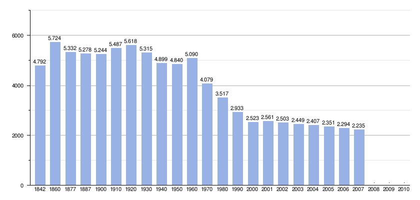 |
by:
Instituto Nacional de Estadística de España - grafic for Wikipedia
|
Points of interest
- El palacio de Valdés Bazán, from 17th century
- La casa de la Torre,
- El palacio de Cañedo
- El palacio de los Casares in San Tirso
See also
References
- ^ Municipal Register of Spain 2018. National Statistics Institute.
External links
- Postal codes [1]
- Federación Asturiana de Concejos (in Spanish)
| International | |
|---|---|
| National | |
|
| This article about a location in the Principality of Asturias, Spain, is a stub. You can help Wikipedia by expanding it. |
Candamo
Candamu | |
|---|---|
|
Flag Coat of arms | |
|
| |
Candamo Location in Spain | |
| Coordinates: 43°26′48″N 6°3′29″W / 43.44667°N 6.05806°W | |
| Country | |
| Autonomous community | |
| Province | Asturias |
| Comarca | Avilés |
| Judicial district | Pravia |
| Capital | Grullos |
| Government | |
| • Alcalde | José Antonio García Vega ( PSOE) |
| Area | |
| • Total | 71.97 km2 (27.79 sq mi) |
| Highest elevation | 613 m (2,011 ft) |
| Population (2018)
[1] | |
| • Total | 1,985 |
| • Density | 28/km2 (71/sq mi) |
| Demonym | candamín / candamina |
| Time zone | UTC+1 ( CET) |
| • Summer ( DST) | UTC+2 ( CEST) |
| Postal code | 33828 and 33829 |
| Website | Official website |
Candamo ( Asturian: Candamu) is a municipality in the Autonomous Community of the Principality of Asturias, Spain. It is bordered on the east by Las Regueras, on the south by Grado, on the north by Illas, Castrillón and Soto del Barco, and on the west by Pravia and Salas.
History
Around Candamo and specially on the shores of the Rio Nalon many paleolithic artifacts have been found. The first documentations about Candamo are from the 11th century and was found in an Monasterys Archive.
Coat of arms
- Left: the coat of arms from Grado.
- Right: a symbol for the boards, Don Pelayo used, to build a bridge over the river, to cross with his soldiers.
Parishes
Politics
| PSOE | PP | IU- BA | CDS | Andere | Total | |
|---|---|---|---|---|---|---|
| 1979 | 1 | 0 | 6 | 0 | 4 | 11 |
| 1983 | 1 | 2 | 8 | - | 0 | 11 |
| 1987 | - | - | 3 | 2 | 6 | 11 |
| 1991 | 9 | 0 | 2 | 0 | 0 | 11 |
| 1995 | 7 | 3 | 1 | - | 0 | 11 |
| 1999 | 9 | 1 | 1 | - | 0 | 11 |
| 2003 | 8 | 2 | 1 | - | 0 | 11 |
| 2007 | 8 | 2 | 1 | - | 0 | 11 |
Demography
|
|
by:
Instituto Nacional de Estadística de España - grafic for Wikipedia
|
Points of interest
- El palacio de Valdés Bazán, from 17th century
- La casa de la Torre,
- El palacio de Cañedo
- El palacio de los Casares in San Tirso
See also
References
- ^ Municipal Register of Spain 2018. National Statistics Institute.
External links
- Postal codes [1]
- Federación Asturiana de Concejos (in Spanish)
| International | |
|---|---|
| National | |
|
| This article about a location in the Principality of Asturias, Spain, is a stub. You can help Wikipedia by expanding it. |