Callalli | |
|---|---|
 | |
 Callalli Location of Callalli in the
Caylloma province | |
| Coordinates: 15°30′26″S 71°26′46″W / 15.5073°S 71.4462°W | |
| Country | |
| Region | Arequipa |
| Province | Caylloma |
| Founded | 1573 |
| Capital | Callalli |
| Government | |
| • Mayor | Florencio Josue Valdivia Mamani |
| Area | |
| • Total | 1,485.1 km2 (573.4 sq mi) |
| Elevation | 3,867 m (12,687 ft) |
| Population (
2005 census) | |
| • Total | 2,554 |
| • Density | 1.7/km2 (4.5/sq mi) |
| Time zone | UTC-5 ( PET) |
| UBIGEO | 040504 |
| Website | https://www.facebook.com/municallalli/ |
Callalli District is one of twenty districts of the Caylloma Province in Peru and is located within the geographical area of the Colca Canyon. [1]
Its capital, Callalli, lies on an ancient trade route for Obsidian that ran from Chivay to Lake Titicaca around 1800-200BC. The earliest findings in the region, carvings of camelids in the Mollupunko Cave, date around 8,000 years back. [2] The town of Callalli was founded as a Spanish Reduccion in 1573 with the initial name of Alcantara de Callalli. [3] [4]
Callalli is the main seat of a catholic pastoral team that takes care of a 7,000 km² area including the towns of Callalli, Sibayo, Tisco, Imata and Caylloma. The parish is led by the Austrian priest and missionary Franz Windischhofer since 1991, whose work was acknowledged by the Peruvian government for "building a community of peace" in Peru since 1980. [5] [6]
Geography
One of the highest mountains of the district is Waran K'anthi at approximately 5,426 m (17,802 ft). Other mountains are listed below: [7]
- Ankachita
- Anta Lluku
- Aqu P'unqu
- Chila
- Chilani
- Chhankarani
- Iru Pampa Pata
- Iru Qullu
- Janq'u Q'awa
- Kunturani
- Puka Qaqa Wasi
- Puka Urqu
- Qaqin Qullu
- Qura Wat'a
- Q'achi Sura
- Q'illu Q'illu
- Q'uwasa
- Salla Phukuruyuq
- Sallqa Chuku
- Saqsa
- Sullu Llump'u
- Wayta Pata
- Wila Wila
- Wiru Pampa Pata
- Wiru Qullu
- Wiswillani
Tourism
- Alpaca Fair, a Caylloma Province regional fair of Alpaca breeders convening in Callalli each June to present their alpacas. [8]
- Mollepunko Caves, a rocky shelter and shallow cave system dating from about 6000 years BC, [2] featuring more than 20 carved cave paintings. [9] Said paintings, made by pre-Inca inhabitants, show the early domestication of Camelids among other figures. The caves were probably used for rituals in the pre-Inca era, and as a grave site after the Incas. Local legends point to an Inca Empire treasure being buried close to a large black boulder, as one of the abandoned deliveries of gold to buy free Atahualpa after his execution.[ citation needed] Multiple excavation attempts - including an intact, 3m long tunnel in front of the caves and a 2.5m deep man-made ravine under the large boulder, point to treasure hunting having taken place.
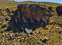
- Enchanted Castles of Callalli, a rock formation featuring jagged boulders directly above the city of Callalli. [10] [11]
- Banos Termales de Inca, a thermal bath complex between Callalli and Sibayo. [12]
- Choqueshisha, a ritual site inside of Callalli where local women thank Pachamama for the gift of water with a sacrifice of Llama fat, corn and other local products once a year. [13]
- Puente de Pachachaca, colonial bridge built with ashlars made of volcanic material and boulder. On the road from Cápac Ñan that runs from Cusco to Arequipa and on the Colca River. [14] The bridge is featured on the upper right part of the coat of arms of Callalli.
- Iglesia Callalli de San Antonio de Padua, a Catholic parish church under the patronage of San Antonio de Padua, built in an Andean Baroque style, located in the town center of Callalli. It features a cross-shaped blueprint and a baptistry, two symmetrical towers on the sides and a vaulted roof. Inside are artworks depicting the miracles of San Antonio. [15]
- Chulpas Tahuaya, an above-ground, Pre-Inca grave site featuring four small stone buildings that contain well-preserved bones and skulls. [16]
- Llapa Yanahuara, an Collagua-Inca-Colonial town, with a church built on top of a pre-Hispanic Huaca. [16]
- Ventana del Colca, a rock formation in the form of a window as a natural entrance to the valley and Colca Canyon. [17]
- Choqolaqa, a large rock formation about 2 hours outside of Callalli, belonging to the district of Tisco, featuring white towers of eroded rocks. A road leads up to an altitude of 4700m; the rock formation itself can be reached after a short hike at an altitude of 4950m. [18]
-
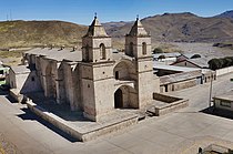 Iglesia Callalli de San Antonio de Padua
 -
 Rock formation a few minutes outside of Callalli
 -
 A herd of alpacas grazing outside of the Mollepunko caves close to Callalli
 -
 A Condor flying over the Colca Canyon
 -
 The "Enchanted Castles of Callalli" above Callalli
 -
 Callalli as seen from the air
 -
 The Callalli Church with rock formation in the background
 -
 Mollepunko Caves outside of Callalli in the Colca Canyon


Ethnic groups
The people in the district are mainly indigenous citizens of Quechua descent. Quechua is the language which the majority of the population (62.06%) learnt to speak in childhood, 37.48% of the residents started speaking using the Spanish language ( 2007 Peru Census). [19]
References
- ^ (in Spanish) Instituto Nacional de Estadística e Informática. Banco de Información Distrital Archived April 23, 2008, at the Wayback Machine. Retrieved April 11, 2008.
- ^ a b Ramos Yuera, Walter Billy (2018). Monografia y Fuentes Documentales sobre la historia del distrito de Callalli. Publicont S.A.C. p. 20.
- ^ Yumpu.com. "este lad". yumpu.com (in Spanish). Retrieved 2019-07-16.
- ^ "Autoridad Autónoma del Colca y Anexos". www.facebook.com. Retrieved 2019-07-16.
- ^ "Se entregaron los "Premios por la Paz 2012"". El PNUD en Perú (in Spanish). Retrieved 2019-07-15.
- ^ "Conozca al sacerdote que aprendió quechua para llevar la palabra de Dios (FOTOS) | Foto 1 de 4". Diario Correo (in Spanish). 2017-05-07. Retrieved 2019-07-15.
- ^ escale.minedu.gob.pe - UGEL maps of the Caylloma Province 2, Arequipa Region
- ^ "Esperan comercializar 300 alpacas por día en feria de Callalli". Infoalpacas (in European Spanish). Retrieved 2019-07-15.
- ^ "COLCA CANYON: PERU'S LESSER KNOWN NATURAL WONDER". viestramagazine.com. Retrieved 2019-07-13.
- ^ "Callalli: tierra de los castillos encantados". RPP (in Spanish). Retrieved 2019-07-13.
- ^ "Callalli – Autocolca" (in Spanish). Retrieved 2019-07-16.
- ^ "Google Maps". Google Maps. Retrieved 2019-07-15.
- ^ "Google Maps". Google Maps. Retrieved 2019-07-16.
- ^ "Google Maps". Google Maps. Retrieved 2019-07-15.
- ^ "Callalli". Archived from the original on 14 March 2009. Retrieved 6 June 2010.
- ^ a b "Arequipa: Chullpas Tahuaya e iglesia Llapa Yanahuara". Google Photos. Retrieved 2019-07-15.
- ^ "Ventana del Colca: Destino De Aventura". De Aventura (in Spanish). Retrieved 2019-07-13.
- ^ "Google Maps". Google Maps. Retrieved 2019-07-15.
- ^ inei.gob.pe Archived January 27, 2013, at the Wayback Machine INEI, Peru, Censos Nacionales 2007, Frequencias: Preguntas de Población: Idioma o lengua con el que aprendió hablar (in Spanish)
Callalli | |
|---|---|
|
| |
Callalli Location of Callalli in the
Caylloma province | |
| Coordinates: 15°30′26″S 71°26′46″W / 15.5073°S 71.4462°W | |
| Country | |
| Region | Arequipa |
| Province | Caylloma |
| Founded | 1573 |
| Capital | Callalli |
| Government | |
| • Mayor | Florencio Josue Valdivia Mamani |
| Area | |
| • Total | 1,485.1 km2 (573.4 sq mi) |
| Elevation | 3,867 m (12,687 ft) |
| Population (
2005 census) | |
| • Total | 2,554 |
| • Density | 1.7/km2 (4.5/sq mi) |
| Time zone | UTC-5 ( PET) |
| UBIGEO | 040504 |
| Website | https://www.facebook.com/municallalli/ |
Callalli District is one of twenty districts of the Caylloma Province in Peru and is located within the geographical area of the Colca Canyon. [1]
Its capital, Callalli, lies on an ancient trade route for Obsidian that ran from Chivay to Lake Titicaca around 1800-200BC. The earliest findings in the region, carvings of camelids in the Mollupunko Cave, date around 8,000 years back. [2] The town of Callalli was founded as a Spanish Reduccion in 1573 with the initial name of Alcantara de Callalli. [3] [4]
Callalli is the main seat of a catholic pastoral team that takes care of a 7,000 km² area including the towns of Callalli, Sibayo, Tisco, Imata and Caylloma. The parish is led by the Austrian priest and missionary Franz Windischhofer since 1991, whose work was acknowledged by the Peruvian government for "building a community of peace" in Peru since 1980. [5] [6]
Geography
One of the highest mountains of the district is Waran K'anthi at approximately 5,426 m (17,802 ft). Other mountains are listed below: [7]
- Ankachita
- Anta Lluku
- Aqu P'unqu
- Chila
- Chilani
- Chhankarani
- Iru Pampa Pata
- Iru Qullu
- Janq'u Q'awa
- Kunturani
- Puka Qaqa Wasi
- Puka Urqu
- Qaqin Qullu
- Qura Wat'a
- Q'achi Sura
- Q'illu Q'illu
- Q'uwasa
- Salla Phukuruyuq
- Sallqa Chuku
- Saqsa
- Sullu Llump'u
- Wayta Pata
- Wila Wila
- Wiru Pampa Pata
- Wiru Qullu
- Wiswillani
Tourism
- Alpaca Fair, a Caylloma Province regional fair of Alpaca breeders convening in Callalli each June to present their alpacas. [8]
- Mollepunko Caves, a rocky shelter and shallow cave system dating from about 6000 years BC, [2] featuring more than 20 carved cave paintings. [9] Said paintings, made by pre-Inca inhabitants, show the early domestication of Camelids among other figures. The caves were probably used for rituals in the pre-Inca era, and as a grave site after the Incas. Local legends point to an Inca Empire treasure being buried close to a large black boulder, as one of the abandoned deliveries of gold to buy free Atahualpa after his execution.[ citation needed] Multiple excavation attempts - including an intact, 3m long tunnel in front of the caves and a 2.5m deep man-made ravine under the large boulder, point to treasure hunting having taken place.
- Enchanted Castles of Callalli, a rock formation featuring jagged boulders directly above the city of Callalli. [10] [11]
- Banos Termales de Inca, a thermal bath complex between Callalli and Sibayo. [12]
- Choqueshisha, a ritual site inside of Callalli where local women thank Pachamama for the gift of water with a sacrifice of Llama fat, corn and other local products once a year. [13]
- Puente de Pachachaca, colonial bridge built with ashlars made of volcanic material and boulder. On the road from Cápac Ñan that runs from Cusco to Arequipa and on the Colca River. [14] The bridge is featured on the upper right part of the coat of arms of Callalli.
- Iglesia Callalli de San Antonio de Padua, a Catholic parish church under the patronage of San Antonio de Padua, built in an Andean Baroque style, located in the town center of Callalli. It features a cross-shaped blueprint and a baptistry, two symmetrical towers on the sides and a vaulted roof. Inside are artworks depicting the miracles of San Antonio. [15]
- Chulpas Tahuaya, an above-ground, Pre-Inca grave site featuring four small stone buildings that contain well-preserved bones and skulls. [16]
- Llapa Yanahuara, an Collagua-Inca-Colonial town, with a church built on top of a pre-Hispanic Huaca. [16]
- Ventana del Colca, a rock formation in the form of a window as a natural entrance to the valley and Colca Canyon. [17]
- Choqolaqa, a large rock formation about 2 hours outside of Callalli, belonging to the district of Tisco, featuring white towers of eroded rocks. A road leads up to an altitude of 4700m; the rock formation itself can be reached after a short hike at an altitude of 4950m. [18]
-
Iglesia Callalli de San Antonio de Padua
-
Rock formation a few minutes outside of Callalli
-
A herd of alpacas grazing outside of the Mollepunko caves close to Callalli
-
A Condor flying over the Colca Canyon
-
The "Enchanted Castles of Callalli" above Callalli
-
Callalli as seen from the air
-
The Callalli Church with rock formation in the background
-
Mollepunko Caves outside of Callalli in the Colca Canyon
Ethnic groups
The people in the district are mainly indigenous citizens of Quechua descent. Quechua is the language which the majority of the population (62.06%) learnt to speak in childhood, 37.48% of the residents started speaking using the Spanish language ( 2007 Peru Census). [19]
References
- ^ (in Spanish) Instituto Nacional de Estadística e Informática. Banco de Información Distrital Archived April 23, 2008, at the Wayback Machine. Retrieved April 11, 2008.
- ^ a b Ramos Yuera, Walter Billy (2018). Monografia y Fuentes Documentales sobre la historia del distrito de Callalli. Publicont S.A.C. p. 20.
- ^ Yumpu.com. "este lad". yumpu.com (in Spanish). Retrieved 2019-07-16.
- ^ "Autoridad Autónoma del Colca y Anexos". www.facebook.com. Retrieved 2019-07-16.
- ^ "Se entregaron los "Premios por la Paz 2012"". El PNUD en Perú (in Spanish). Retrieved 2019-07-15.
- ^ "Conozca al sacerdote que aprendió quechua para llevar la palabra de Dios (FOTOS) | Foto 1 de 4". Diario Correo (in Spanish). 2017-05-07. Retrieved 2019-07-15.
- ^ escale.minedu.gob.pe - UGEL maps of the Caylloma Province 2, Arequipa Region
- ^ "Esperan comercializar 300 alpacas por día en feria de Callalli". Infoalpacas (in European Spanish). Retrieved 2019-07-15.
- ^ "COLCA CANYON: PERU'S LESSER KNOWN NATURAL WONDER". viestramagazine.com. Retrieved 2019-07-13.
- ^ "Callalli: tierra de los castillos encantados". RPP (in Spanish). Retrieved 2019-07-13.
- ^ "Callalli – Autocolca" (in Spanish). Retrieved 2019-07-16.
- ^ "Google Maps". Google Maps. Retrieved 2019-07-15.
- ^ "Google Maps". Google Maps. Retrieved 2019-07-16.
- ^ "Google Maps". Google Maps. Retrieved 2019-07-15.
- ^ "Callalli". Archived from the original on 14 March 2009. Retrieved 6 June 2010.
- ^ a b "Arequipa: Chullpas Tahuaya e iglesia Llapa Yanahuara". Google Photos. Retrieved 2019-07-15.
- ^ "Ventana del Colca: Destino De Aventura". De Aventura (in Spanish). Retrieved 2019-07-13.
- ^ "Google Maps". Google Maps. Retrieved 2019-07-15.
- ^ inei.gob.pe Archived January 27, 2013, at the Wayback Machine INEI, Peru, Censos Nacionales 2007, Frequencias: Preguntas de Población: Idioma o lengua con el que aprendió hablar (in Spanish)