Photos • Location
Caiçara | |
|---|---|
Municipality | |
| The Municipality of Caiçara | |
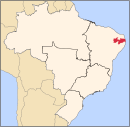
 Location of Caiçara in the
State of Paraíba | |
| Coordinates: 06°33′14″S 35°24′39″W / 6.55389°S 35.41083°W | |
| Country | |
| Region | Northeast |
| State |
|
| Founded | November 7, 1908 |
| Government | |
| • Mayor | Hugo Antonio Lisboa Alves ( PMDB) |
| Area | |
| • Total | 127.911 km2 (49.387 sq mi) |
| Elevation | 150 m (490 ft) |
| Population (2020
[1]) | |
| • Total | 7,191 |
| • Density | 56/km2 (150/sq mi) |
| Time zone | UTC−3 ( BRT) |
| HDI (2000) | 0.576 – medium [2] |
Caiçara is a municipality in the Brazilian state of Paraíba.
- ^ IBGE 2020
-
^
"Archived copy". Archived from
the original on 2009-10-03. Retrieved 2009-12-17.
{{
cite web}}
: CS1 maint: archived copy as title ( link) - UNDP
Caiçara | |
|---|---|
Municipality | |
| The Municipality of Caiçara | |
 Location of Caiçara in the
State of Paraíba | |
| Coordinates: 06°33′14″S 35°24′39″W / 6.55389°S 35.41083°W | |
| Country | |
| Region | Northeast |
| State |
|
| Founded | November 7, 1908 |
| Government | |
| • Mayor | Hugo Antonio Lisboa Alves ( PMDB) |
| Area | |
| • Total | 127.911 km2 (49.387 sq mi) |
| Elevation | 150 m (490 ft) |
| Population (2020
[1]) | |
| • Total | 7,191 |
| • Density | 56/km2 (150/sq mi) |
| Time zone | UTC−3 ( BRT) |
| HDI (2000) | 0.576 – medium [2] |
Caiçara is a municipality in the Brazilian state of Paraíba.
- ^ IBGE 2020
-
^
"Archived copy". Archived from
the original on 2009-10-03. Retrieved 2009-12-17.
{{
cite web}}
: CS1 maint: archived copy as title ( link) - UNDP


