Photos • Location
Cà Lồ River

(Redirected from
Ca Lo River)

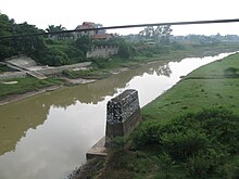
The Cà Lồ River ( Vietnamese: Sông Cà Lồ) is a river of Vietnam. It flows through Vĩnh Phúc Province, Hanoi and Bắc Ninh Province for 89 kilometres and has a basin area of 880 km². [1] [2]
- ^ Tình hình suy giảm chất lượng và ô nhiễm môi trường lưu vực sông Cầu
- ^ Ảnh hưởng của dự án xây dựng đường cao tốc Hà Nội-Thái Nguyên (quốc lộ 3 mới) tới môi trường nước mặn Archived 2010-01-20 at the Wayback Machine, trang 504 trong Kỷ yếu Hội thảo Khoa học lần thứ 9 của Viện Khí tượng thủy văn, tập tin pdf tách ra, trang 3
21°14′37″N 105°56′15″E / 21.2436°N 105.9375°E
|
| This article about a location in Vĩnh Phúc Province, Vietnam is a stub. You can help Wikipedia by expanding it. |
(Redirected from
Ca Lo River)
The Cà Lồ River ( Vietnamese: Sông Cà Lồ) is a river of Vietnam. It flows through Vĩnh Phúc Province, Hanoi and Bắc Ninh Province for 89 kilometres and has a basin area of 880 km². [1] [2]
- ^ Tình hình suy giảm chất lượng và ô nhiễm môi trường lưu vực sông Cầu
- ^ Ảnh hưởng của dự án xây dựng đường cao tốc Hà Nội-Thái Nguyên (quốc lộ 3 mới) tới môi trường nước mặn Archived 2010-01-20 at the Wayback Machine, trang 504 trong Kỷ yếu Hội thảo Khoa học lần thứ 9 của Viện Khí tượng thủy văn, tập tin pdf tách ra, trang 3
21°14′37″N 105°56′15″E / 21.2436°N 105.9375°E
|
| This article about a location in Vĩnh Phúc Province, Vietnam is a stub. You can help Wikipedia by expanding it. |