| Càrn Mòr Dearg | |
|---|---|
 Càrn Mòr Dearg, with several climbers on the summit | |
| Highest point | |
| Elevation | 1,220 m (4,003 feet) [1] |
| Prominence | 162 m (531 ft) |
| Parent peak | Ben Nevis |
| Listing | Munro, Marilyn |
| Naming | |
| English translation | great red peak |
| Language of name | Scottish Gaelic |
| Pronunciation | Scottish Gaelic:
[ˈkʰaːrˠn ˈmoːɾ ˈtʲɛɾɛk] English approximation: KARN-mor-JERR-ek |
| Geography | |
| Location | Lochaber, Scotland |
| Parent range | Grampian Mountains |
| OS grid | NN177722 |
| Topo map | OS Landranger 41 |
Càrn Mòr Dearg ( Scottish Gaelic for 'great red peak') is the ninth-highest mountain in Scotland and the British Isles, with a height of 1,220 metres (4,000 ft). It stands a short distance northeast of Ben Nevis, the highest mountain in Britain, to which it is linked by the 'Càrn Mòr Dearg arête'. Along with Càrn Dearg Meadhanach ('middle red peak') and Càrn Beag Dearg ('little red peak'), it makes up the eastern ridge of the horseshoe-shaped Ben Nevis massif in the Scottish Highlands.
The ascent of Càrn Mòr Dearg from the north (start from the North Face Car Park), the traverse of the arête, and the scramble up the north side of Ben Nevis make one of the best horse-shoe routes in Scotland. [2]
Càrn Mòr Dearg is attractive to ski mountaineers and off piste skiers and boarders. In good conditions the summit can be reached from the nearby Nevis Range Ski areas in two hours or less. With enough snow, the descent from the summit to the CIC Hut gives a long, pleasant grade 1 descent. The eastern flank of the mountain has three fine bowls which give descents graded between 2 and 5 in K. Biggin's guide. [3]
-
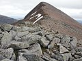 Càrn Mòr Dearg summit
 -
 Càrn Mòr Dearg and Càrn Dearg Meadhanach, from Ben Nevis to the west
 -
 Càrn Mòr Dearg (left), Càrn Dearg Meadhanach (middle) and Càrn Beag Dearg (right), with Ben Nevis behind, from Aonach Mòr to the east
 -
 Càrn Mòr Dearg from Aonach Mòr showing the snow bowl that attracts off-piste snowsports enthusiasts
 -
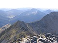 Càrn Mòr Dearg arête


- ^ "Càrn Mòr Dearg". Hill Bagging - the online version of the Database of British and Irish Hills (DoBIH). 2019. Retrieved 20 June 2019.
- ^ Irvine Butterfield (1986). The High Mountains of Britain and Ireland. London: Diadem Books. p. 98. ISBN 0-906371-71-6.
- ^ Kenny Biggin, Scottish Offpiste Skiing and Snowboarding : Nevis Range and Ben Nevis (Spean Bridge : Skimountain, 2013) 97–105.
- 360munros.co.uk - Càrn Mòr Dearg Arête 360° Virtual Tour
 | Nevis range |  | |
|---|---|---|---|
| Mamores | |||
| Grey Corries | |||
| Alder/Ardverikie | |||
| Ossian/Treig | |||
56°48′20″N 4°59′15″W / 56.80549°N 4.98744°W
|
| This Highland location article is a stub. You can help Wikipedia by expanding it. |
| Càrn Mòr Dearg | |
|---|---|
|
Càrn Mòr Dearg, with several climbers on the summit | |
| Highest point | |
| Elevation | 1,220 m (4,003 feet) [1] |
| Prominence | 162 m (531 ft) |
| Parent peak | Ben Nevis |
| Listing | Munro, Marilyn |
| Naming | |
| English translation | great red peak |
| Language of name | Scottish Gaelic |
| Pronunciation | Scottish Gaelic:
[ˈkʰaːrˠn ˈmoːɾ ˈtʲɛɾɛk] English approximation: KARN-mor-JERR-ek |
| Geography | |
| Location | Lochaber, Scotland |
| Parent range | Grampian Mountains |
| OS grid | NN177722 |
| Topo map | OS Landranger 41 |
Càrn Mòr Dearg ( Scottish Gaelic for 'great red peak') is the ninth-highest mountain in Scotland and the British Isles, with a height of 1,220 metres (4,000 ft). It stands a short distance northeast of Ben Nevis, the highest mountain in Britain, to which it is linked by the 'Càrn Mòr Dearg arête'. Along with Càrn Dearg Meadhanach ('middle red peak') and Càrn Beag Dearg ('little red peak'), it makes up the eastern ridge of the horseshoe-shaped Ben Nevis massif in the Scottish Highlands.
The ascent of Càrn Mòr Dearg from the north (start from the North Face Car Park), the traverse of the arête, and the scramble up the north side of Ben Nevis make one of the best horse-shoe routes in Scotland. [2]
Càrn Mòr Dearg is attractive to ski mountaineers and off piste skiers and boarders. In good conditions the summit can be reached from the nearby Nevis Range Ski areas in two hours or less. With enough snow, the descent from the summit to the CIC Hut gives a long, pleasant grade 1 descent. The eastern flank of the mountain has three fine bowls which give descents graded between 2 and 5 in K. Biggin's guide. [3]
-
Càrn Mòr Dearg summit
-
Càrn Mòr Dearg and Càrn Dearg Meadhanach, from Ben Nevis to the west
-
Càrn Mòr Dearg (left), Càrn Dearg Meadhanach (middle) and Càrn Beag Dearg (right), with Ben Nevis behind, from Aonach Mòr to the east
-
Càrn Mòr Dearg from Aonach Mòr showing the snow bowl that attracts off-piste snowsports enthusiasts
-
Càrn Mòr Dearg arête
- ^ "Càrn Mòr Dearg". Hill Bagging - the online version of the Database of British and Irish Hills (DoBIH). 2019. Retrieved 20 June 2019.
- ^ Irvine Butterfield (1986). The High Mountains of Britain and Ireland. London: Diadem Books. p. 98. ISBN 0-906371-71-6.
- ^ Kenny Biggin, Scottish Offpiste Skiing and Snowboarding : Nevis Range and Ben Nevis (Spean Bridge : Skimountain, 2013) 97–105.
- 360munros.co.uk - Càrn Mòr Dearg Arête 360° Virtual Tour
| Nevis range | | |
|---|---|---|---|
| Mamores | |||
| Grey Corries | |||
| Alder/Ardverikie | |||
| Ossian/Treig | |||
56°48′20″N 4°59′15″W / 56.80549°N 4.98744°W
|
| This Highland location article is a stub. You can help Wikipedia by expanding it. |