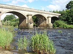
Bywell Bridge | |
|---|---|
 Bywell Bridge | |
| Coordinates | 54°57′07″N 1°55′12″W / 54.952°N 1.920°W |
| OS grid reference | NZ052619 |
| Carries | B6309 |
| Crosses | River Tyne |
| Locale | Northumberland |
| Heritage status | Grade II listed [1] [2] |
| Preceded by | Styford Bridge |
| Followed by | Ovingham Bridges |
| Characteristics | |
| Design | Arch bridge |
| Material | Ashlar stone |
| No. of spans | 5 |
| No. of lanes | Single-track road |
| History | |
| Architect | George Basevi [3] |
| Construction start | 1836 [4] |
| Construction end | 1838 |
| Construction cost | £15,000 |
| Opened | 1838 [3] [4] |
| Location | |
|
| |
Bywell Bridge is a 19th-century stone bridge across the River Tyne. It is a Grade II listed building. [1] [2] [4]
The bridge was opened in 1838. It was built at a cost of £15,000, which was paid by the local landowner T W Beaumont. [5] The designer was the architect George Basevi. [3] The bridge joins Bywell and the adjoining roads with Stocksfield. It is of ashlar masonry, with five segmental arches crossing the river, and two flood arches, without parapets, to the south. [6]
The remains of the piers of an ancient bridge, believed to be Roman, stood nearby until demolished on Beaumont's instructions when work on the present bridge began. [7] [8]
- ^ a b Historic England. "Details from listed building database (1303849)". National Heritage List for England. Retrieved 6 September 2018.
- ^ a b Historic England. "Details from listed building database (1154576)". National Heritage List for England. Retrieved 6 September 2018.
- ^ a b c "Bywell Bridge". Bridges on the Tyne. Retrieved 30 May 2009.
- ^ a b c "Bywell Bridge". Keys to the Past. Archived from the original on 22 February 2012. Retrieved 9 July 2009.
- ^ Handbook for travellers in Durham and Northumberland. London: John Murray. 1864. p. 243. Retrieved 2 July 2011.
- ^ Historic England. "Bywell Bridge (Grade II) (1154576)". National Heritage List for England. Retrieved 23 May 2011.
- ^ "Structure Details for Bywell Bridge". SINE Project. Newcastle University. Archived from the original on 19 March 2012. Retrieved 2 July 2011.
- ^ Views on the Newcastle and Carlisle railway, from drawings by J.W. Carmichael, with details by J. Blackmore, 1836
-
 Media related to
Bywell Bridge at Wikimedia Commons
Bywell Bridge | |
|---|---|
 Bywell Bridge | |
| Coordinates | 54°57′07″N 1°55′12″W / 54.952°N 1.920°W |
| OS grid reference | NZ052619 |
| Carries | B6309 |
| Crosses | River Tyne |
| Locale | Northumberland |
| Heritage status | Grade II listed [1] [2] |
| Preceded by | Styford Bridge |
| Followed by | Ovingham Bridges |
| Characteristics | |
| Design | Arch bridge |
| Material | Ashlar stone |
| No. of spans | 5 |
| No. of lanes | Single-track road |
| History | |
| Architect | George Basevi [3] |
| Construction start | 1836 [4] |
| Construction end | 1838 |
| Construction cost | £15,000 |
| Opened | 1838 [3] [4] |
| Location | |
|
| |
Bywell Bridge is a 19th-century stone bridge across the River Tyne. It is a Grade II listed building. [1] [2] [4]
The bridge was opened in 1838. It was built at a cost of £15,000, which was paid by the local landowner T W Beaumont. [5] The designer was the architect George Basevi. [3] The bridge joins Bywell and the adjoining roads with Stocksfield. It is of ashlar masonry, with five segmental arches crossing the river, and two flood arches, without parapets, to the south. [6]
The remains of the piers of an ancient bridge, believed to be Roman, stood nearby until demolished on Beaumont's instructions when work on the present bridge began. [7] [8]
- ^ a b Historic England. "Details from listed building database (1303849)". National Heritage List for England. Retrieved 6 September 2018.
- ^ a b Historic England. "Details from listed building database (1154576)". National Heritage List for England. Retrieved 6 September 2018.
- ^ a b c "Bywell Bridge". Bridges on the Tyne. Retrieved 30 May 2009.
- ^ a b c "Bywell Bridge". Keys to the Past. Archived from the original on 22 February 2012. Retrieved 9 July 2009.
- ^ Handbook for travellers in Durham and Northumberland. London: John Murray. 1864. p. 243. Retrieved 2 July 2011.
- ^ Historic England. "Bywell Bridge (Grade II) (1154576)". National Heritage List for England. Retrieved 23 May 2011.
- ^ "Structure Details for Bywell Bridge". SINE Project. Newcastle University. Archived from the original on 19 March 2012. Retrieved 2 July 2011.
- ^ Views on the Newcastle and Carlisle railway, from drawings by J.W. Carmichael, with details by J. Blackmore, 1836
-
 Media related to
Bywell Bridge at Wikimedia Commons