Byrkjelo | |
|---|---|
Village | |
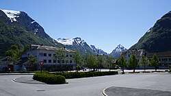
 View of Byrkjelo | |
| Coordinates: 61°43′59″N 6°30′19″E / 61.7330°N 6.5053°E | |
| Country | Norway |
| Region | Western Norway |
| County | Vestland |
| District | Nordfjord |
| Municipality | Gloppen |
| Area | |
| • Total | 0.5 km2 (0.2 sq mi) |
| Elevation | 141 m (463 ft) |
| Population (2019)
[1] | |
| • Total | 324 |
| • Density | 648/km2 (1,680/sq mi) |
| Time zone | UTC+01:00 ( CET) |
| • Summer ( DST) | UTC+02:00 ( CEST) |
| Post Code | 6826 Byrkjelo |
Byrkjelo is a village in the municipality of Gloppen in Vestland county, Norway. It is located about halfway between the villages of Sandane (in Gloppen) and Skei (in Sunnfjord) along the European route E39 highway. The village of Re lies about 5 kilometres (3.1 mi) to the west and the small village of Egge lies about 5 kilometres (3.1 mi) to the south.
The 0.5-square-kilometre (120-acre) village has a population (2019) of 324 and a population density of 648 inhabitants per square kilometre (1,680/sq mi). [1]

Byrkjelo is located near the great Jostedalsbreen National Park, the Myklebustbreen glacier, and the lake Breimsvatn. Byrkjelo Stadium is used for several large athletic competitions each year. One of the largest dairy factories in Western Norway is located in Byrkjelo. It is operated by Tine. [3]
References
- ^ a b c Statistisk sentralbyrå (1 January 2019). "Urban settlements. Population and area, by municipality".
- ^ "Byrkjelo, Gloppen (Sogn og Fjordane)". yr.no. Retrieved 2019-11-06.
- ^ "Byrkjelo Dairy Factory" (in Norwegian). Archived from the original on 24 August 2007. Retrieved 9 September 2008.
Byrkjelo | |
|---|---|
Village | |
 View of Byrkjelo | |
| Coordinates: 61°43′59″N 6°30′19″E / 61.7330°N 6.5053°E | |
| Country | Norway |
| Region | Western Norway |
| County | Vestland |
| District | Nordfjord |
| Municipality | Gloppen |
| Area | |
| • Total | 0.5 km2 (0.2 sq mi) |
| Elevation | 141 m (463 ft) |
| Population (2019)
[1] | |
| • Total | 324 |
| • Density | 648/km2 (1,680/sq mi) |
| Time zone | UTC+01:00 ( CET) |
| • Summer ( DST) | UTC+02:00 ( CEST) |
| Post Code | 6826 Byrkjelo |
Byrkjelo is a village in the municipality of Gloppen in Vestland county, Norway. It is located about halfway between the villages of Sandane (in Gloppen) and Skei (in Sunnfjord) along the European route E39 highway. The village of Re lies about 5 kilometres (3.1 mi) to the west and the small village of Egge lies about 5 kilometres (3.1 mi) to the south.
The 0.5-square-kilometre (120-acre) village has a population (2019) of 324 and a population density of 648 inhabitants per square kilometre (1,680/sq mi). [1]

Byrkjelo is located near the great Jostedalsbreen National Park, the Myklebustbreen glacier, and the lake Breimsvatn. Byrkjelo Stadium is used for several large athletic competitions each year. One of the largest dairy factories in Western Norway is located in Byrkjelo. It is operated by Tine. [3]
References
- ^ a b c Statistisk sentralbyrå (1 January 2019). "Urban settlements. Population and area, by municipality".
- ^ "Byrkjelo, Gloppen (Sogn og Fjordane)". yr.no. Retrieved 2019-11-06.
- ^ "Byrkjelo Dairy Factory" (in Norwegian). Archived from the original on 24 August 2007. Retrieved 9 September 2008.

