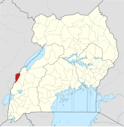
Bunyamwera | |
|---|---|
| Coordinates: 0°35′45″N 29°59′54″E / 0.59584°N 29.99841°E [1] | |
| Country | |
| Region | Western Uganda |
| Subregion | |
| District | Bundibugyo District |
| County | Bughendera |
| Subcounty | Sindila |
| Parish | Bunyamwera |
| Elevation | 4,216 ft (1,285 m) |
| Population (2002)
[2] | |
| • Total | 3,740 |
| • Estimate (2008)
[2] | 5,022 |
Bunyamwera is a town in Bundibugyo District, Uganda. [2] It lies just outside of Rwenzori Mountains National Park, which is to the south. The town is north of Kagugu, southeast of Bunyana, and southwest of Butama. [1] Other nearby settlements include Bundimbuga, 1½ km north, and Bundikahondo, 2 km northwest. [1] The peak of Busunga is 6 km northwest, Kyabwageya's peak is 10 km east, and Kinera's peak is 10 km east. [1] The nearest hospital, Kasulenge Health Center II, is 9 km northeast. [1]
In the 1950s, Bunyamwera was considered a Konzo spur village, and children there went to primary school in the parish of Mutunda. [3]
Bunyamwera parish includes two hydropower plants, Ndugutu and Sindila. [4]
Bunyamwera is where Bunyamwera orthobunyavirus was first isolated, [5] and it also lends its name to that virus' genus Orthobunyavirus, its family Peribunyaviridae, and its order Bunyavirales. [6]
References
- ^ a b c d e f "Bunyamwera". Mapcarta. Archived from the original on 1 February 2019. Retrieved 31 January 2019.
- ^ a b c Tibemanya, Jolly; Okolli, Richard (June 2012). "Bundibugyo Local Government Statistical Abstract" (PDF). Uganda Bureau of Statistics. Bundibugyo, Uganda. p. 52. Archived (PDF) from the original on 1 February 2019. Retrieved 31 January 2019.
- ^ Stacey, Tom (2003). "XV The BLHRS Takes Off". Tribe: The Hidden History of the Mountains of the Moon. London: Stacey International. p. 185. ISBN 1900988763.
- ^ Bulafu, Collins Edward; David Mwesigye, Tumusiime; Hårklau, Svein Erik; Owuor, George (8 November 2020). "Status of illegal resource extraction within Rwenzori Mountains National Park, Uganda: Baseline studies near four hydropower projects". African Journal of Ecology. 59 (2): 449–465. doi: 10.1111/aje.12823. S2CID 228809768. Retrieved 1 September 2022.
- ^ Smithburn, K. C.; Haddow, A. J.; Mahaffy, A. F. (March 1946). "A Neurotropic Virus Isolated from Aedes Mosquitoes Caught in the Semliki Forest". The American Journal of Tropical Medicine and Hygiene. s1-26 (2): 189–208. doi: 10.4269/ajtmh.1946.s1-26.189. ISSN 1476-1645. OCLC 677158400. PMID 21020339.
-
^
"ICTV 9th Report (2011) Bunyaviridae". International Committee on Taxonomy of Viruses (ICTV).
Archived from the original on 11 December 2018. Retrieved 31 January 2019.
Bunya: from Bunyamwera, place in Uganda, where type virus was isolated.

