Photos • Location

| S-train station | |||||||||||||||
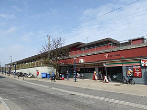
 Buddinge station in 2016 | |||||||||||||||
| General information | |||||||||||||||
| Location | 270 Buddingevej 2860 Søborg [1] Gladsaxe Municipality Denmark | ||||||||||||||
| Coordinates | 55°44′50″N 12°29′36″E / 55.74722°N 12.49333°E | ||||||||||||||
| Owned by | DSB | ||||||||||||||
| Platforms | Island platform | ||||||||||||||
| Tracks | 2 | ||||||||||||||
| History | |||||||||||||||
| Opened | 1906 | ||||||||||||||
| Services | |||||||||||||||
| |||||||||||||||
Buddinge station is a suburban rail railway station serving the suburb of Buddinge northwest of Copenhagen, Denmark. [1] The station is located on the Farum radial of Copenhagen's S-train network. [1]
See also
References
- ^ a b c "Buddinge Station" (in Danish). DSB. Retrieved January 8, 2024.
External links
Wikimedia Commons has media related to
Buddinge Station.
| S-train station | |||||||||||||||
 Buddinge station in 2016 | |||||||||||||||
| General information | |||||||||||||||
| Location | 270 Buddingevej 2860 Søborg [1] Gladsaxe Municipality Denmark | ||||||||||||||
| Coordinates | 55°44′50″N 12°29′36″E / 55.74722°N 12.49333°E | ||||||||||||||
| Owned by | DSB | ||||||||||||||
| Platforms | Island platform | ||||||||||||||
| Tracks | 2 | ||||||||||||||
| History | |||||||||||||||
| Opened | 1906 | ||||||||||||||
| Services | |||||||||||||||
| |||||||||||||||
Buddinge station is a suburban rail railway station serving the suburb of Buddinge northwest of Copenhagen, Denmark. [1] The station is located on the Farum radial of Copenhagen's S-train network. [1]
See also
References
- ^ a b c "Buddinge Station" (in Danish). DSB. Retrieved January 8, 2024.
External links
Wikimedia Commons has media related to
Buddinge Station.