Photos • Location
Broughderg, County Tyrone
| |
|---|---|
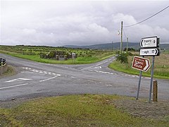
 Crossroads at Broughderg in 2007 | |
| County | |
| Country | Northern Ireland |
| Sovereign state | United Kingdom |
| Postcode district | BT79 |
| Dialling code | 028 |
Broughderg (from Irish Bruach Dearg, meaning 'red bank/edge') [1] is a townland of 4,239 acres in County Tyrone, Northern Ireland, 16 km north-west of Cookstown. It is situated in the civil parish of Lissan and the historic barony of Dungannon Upper. [2]
- ^ "Broughderg". Place Names NI. Retrieved 11 May 2015.
- ^ "Broughderg". IreAtlas Townlands Database. Retrieved 11 May 2015.
54°43′N 7°00′W / 54.717°N 7.000°W
Broughderg, County Tyrone
| |
|---|---|
 Crossroads at Broughderg in 2007 | |
| County | |
| Country | Northern Ireland |
| Sovereign state | United Kingdom |
| Postcode district | BT79 |
| Dialling code | 028 |
Broughderg (from Irish Bruach Dearg, meaning 'red bank/edge') [1] is a townland of 4,239 acres in County Tyrone, Northern Ireland, 16 km north-west of Cookstown. It is situated in the civil parish of Lissan and the historic barony of Dungannon Upper. [2]
- ^ "Broughderg". Place Names NI. Retrieved 11 May 2015.
- ^ "Broughderg". IreAtlas Townlands Database. Retrieved 11 May 2015.
54°43′N 7°00′W / 54.717°N 7.000°W