Photos • Location
 Brazos Island and
South Bay | |
| Geography | |
|---|---|
| Location | Gulf of Mexico |
| Coordinates | 26°01′50″N 97°09′27″W / 26.03056°N 97.15750°W |
| Archipelago | Texas barrier islands |
| Administration | |
United States | |
| State | Texas |
| County | Cameron County |
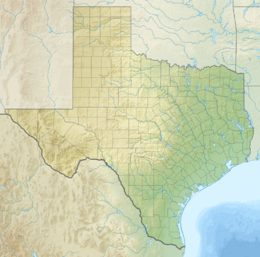
Brazos Island, also known as Brazos Santiago Island, is a barrier island on the Gulf Coast of Texas in the United States, south of the town of South Padre Island. The island is located in Cameron County.
Brazos Santiago Pass partitions the barrier islands of Brazos Island and Padre Island in the Lower Rio Grande Valley.
References
- Brazos Island from the Handbook of Texas Online
- Brazos Island State Scenic Park from the Handbook of Texas Online
- "A Decade of Beneficial Use, Brazos Island Harbor, Dredging" by T. Neil McLellan, P.E., Herbie Maurer, P.E., Bob Fudge, P.E., and Dan J. Heilman, P.E.
- A description of the Expedition from Brazos Santiago
External links
 Brazos Island and
South Bay | |
| Geography | |
|---|---|
| Location | Gulf of Mexico |
| Coordinates | 26°01′50″N 97°09′27″W / 26.03056°N 97.15750°W |
| Archipelago | Texas barrier islands |
| Administration | |
United States | |
| State | Texas |
| County | Cameron County |
Brazos Island, also known as Brazos Santiago Island, is a barrier island on the Gulf Coast of Texas in the United States, south of the town of South Padre Island. The island is located in Cameron County.
Brazos Santiago Pass partitions the barrier islands of Brazos Island and Padre Island in the Lower Rio Grande Valley.
References
- Brazos Island from the Handbook of Texas Online
- Brazos Island State Scenic Park from the Handbook of Texas Online
- "A Decade of Beneficial Use, Brazos Island Harbor, Dredging" by T. Neil McLellan, P.E., Herbie Maurer, P.E., Bob Fudge, P.E., and Dan J. Heilman, P.E.
- A description of the Expedition from Brazos Santiago

