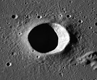
Lunar Orbiter 4 image | |
| Coordinates | 20°54′N 36°54′W / 20.9°N 36.9°W |
|---|---|
| Diameter | 14.5 km |
| Depth | 2.8 km |
| Colongitude | 37° at sunrise |
| Eponym | Edward W. Brayley |


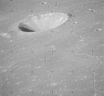
Brayley is a lunar impact crater located in the southwest part of the Mare Imbrium. It was named after British geographer Edward W. Brayley in 1935. [2] It has a circular rim and a low rise in the center. There are no notable craters overlapping the rim or interior. The sinuous rille Rima Brayley passes to the north of Brayley.
Brayley is a crater of Eratosthenian age. [3]
By convention these features are identified on lunar maps by placing the letter on the side of the crater midpoint that is closest to Brayley.
| Brayley | Latitude | Longitude | Diameter |
|---|---|---|---|
| B | 20.8° N | 34.3° W | 10 km |
| C | 21.4° N | 39.4° W | 9 km |
| D | 20.1° N | 32.8° W | 6 km |
| E | 21.2° N | 39.7° W | 5 km |
| F | 21.1° N | 34.0° W | 5 km |
| G | 24.2° N | 36.5° W | 5 km |
| K | 21.2° N | 41.7° W | 3 km |
| L | 20.9° N | 42.6° W | 4 km |
| S | 25.0° N | 36.7° W | 3 km |

- ^ Apollo Over the Moon: A View From Orbit, NASA SP-362, 1978, Figure 228.
- ^ "Brayley (crater)". Gazetteer of Planetary Nomenclature. USGS Astrogeology Research Program.
- ^ The geologic history of the Moon. USGS Professional Paper 1348. By Don E. Wilhelms, John F. McCauley, and Newell J. Trask. U.S. Government Printing Office, Washington: 1987. Table 12.2.
- Andersson, L. E.; Whitaker, E. A. (1982). NASA Catalogue of Lunar Nomenclature. NASA RP-1097.
- Bussey, B.; Spudis, P. (2004). The Clementine Atlas of the Moon. New York: Cambridge University Press. ISBN 978-0-521-81528-4.
- Cocks, Elijah E.; Cocks, Josiah C. (1995). Who's Who on the Moon: A Biographical Dictionary of Lunar Nomenclature. Tudor Publishers. ISBN 978-0-936389-27-1.
- McDowell, Jonathan (July 15, 2007). "Lunar Nomenclature". Jonathan's Space Report. Retrieved 2007-10-24.
- Menzel, D. H.; Minnaert, M.; Levin, B.; Dollfus, A.; Bell, B. (1971). "Report on Lunar Nomenclature by the Working Group of Commission 17 of the IAU". Space Science Reviews. 12 (2): 136–186. Bibcode: 1971SSRv...12..136M. doi: 10.1007/BF00171763. S2CID 122125855.
- Moore, Patrick (2001). On the Moon. Sterling Publishing Co. ISBN 978-0-304-35469-6.
- Price, Fred W. (1988). The Moon Observer's Handbook. Cambridge University Press. ISBN 978-0-521-33500-3.
- Rükl, Antonín (1990). Atlas of the Moon. Kalmbach Books. ISBN 978-0-913135-17-4.
- Webb, Rev. T. W. (1962). Celestial Objects for Common Telescopes (6th revised ed.). Dover. ISBN 978-0-486-20917-3.
- Whitaker, Ewen A. (1999). Mapping and Naming the Moon. Cambridge University Press. ISBN 978-0-521-62248-6.
- Wlasuk, Peter T. (2000). Observing the Moon. Springer. ISBN 978-1-85233-193-1.
- LTO-39C1 Brayley — L&PI topographic map

Lunar Orbiter 4 image | |
| Coordinates | 20°54′N 36°54′W / 20.9°N 36.9°W |
|---|---|
| Diameter | 14.5 km |
| Depth | 2.8 km |
| Colongitude | 37° at sunrise |
| Eponym | Edward W. Brayley |


Brayley is a lunar impact crater located in the southwest part of the Mare Imbrium. It was named after British geographer Edward W. Brayley in 1935. [2] It has a circular rim and a low rise in the center. There are no notable craters overlapping the rim or interior. The sinuous rille Rima Brayley passes to the north of Brayley.
Brayley is a crater of Eratosthenian age. [3]
By convention these features are identified on lunar maps by placing the letter on the side of the crater midpoint that is closest to Brayley.
| Brayley | Latitude | Longitude | Diameter |
|---|---|---|---|
| B | 20.8° N | 34.3° W | 10 km |
| C | 21.4° N | 39.4° W | 9 km |
| D | 20.1° N | 32.8° W | 6 km |
| E | 21.2° N | 39.7° W | 5 km |
| F | 21.1° N | 34.0° W | 5 km |
| G | 24.2° N | 36.5° W | 5 km |
| K | 21.2° N | 41.7° W | 3 km |
| L | 20.9° N | 42.6° W | 4 km |
| S | 25.0° N | 36.7° W | 3 km |

- ^ Apollo Over the Moon: A View From Orbit, NASA SP-362, 1978, Figure 228.
- ^ "Brayley (crater)". Gazetteer of Planetary Nomenclature. USGS Astrogeology Research Program.
- ^ The geologic history of the Moon. USGS Professional Paper 1348. By Don E. Wilhelms, John F. McCauley, and Newell J. Trask. U.S. Government Printing Office, Washington: 1987. Table 12.2.
- Andersson, L. E.; Whitaker, E. A. (1982). NASA Catalogue of Lunar Nomenclature. NASA RP-1097.
- Bussey, B.; Spudis, P. (2004). The Clementine Atlas of the Moon. New York: Cambridge University Press. ISBN 978-0-521-81528-4.
- Cocks, Elijah E.; Cocks, Josiah C. (1995). Who's Who on the Moon: A Biographical Dictionary of Lunar Nomenclature. Tudor Publishers. ISBN 978-0-936389-27-1.
- McDowell, Jonathan (July 15, 2007). "Lunar Nomenclature". Jonathan's Space Report. Retrieved 2007-10-24.
- Menzel, D. H.; Minnaert, M.; Levin, B.; Dollfus, A.; Bell, B. (1971). "Report on Lunar Nomenclature by the Working Group of Commission 17 of the IAU". Space Science Reviews. 12 (2): 136–186. Bibcode: 1971SSRv...12..136M. doi: 10.1007/BF00171763. S2CID 122125855.
- Moore, Patrick (2001). On the Moon. Sterling Publishing Co. ISBN 978-0-304-35469-6.
- Price, Fred W. (1988). The Moon Observer's Handbook. Cambridge University Press. ISBN 978-0-521-33500-3.
- Rükl, Antonín (1990). Atlas of the Moon. Kalmbach Books. ISBN 978-0-913135-17-4.
- Webb, Rev. T. W. (1962). Celestial Objects for Common Telescopes (6th revised ed.). Dover. ISBN 978-0-486-20917-3.
- Whitaker, Ewen A. (1999). Mapping and Naming the Moon. Cambridge University Press. ISBN 978-0-521-62248-6.
- Wlasuk, Peter T. (2000). Observing the Moon. Springer. ISBN 978-1-85233-193-1.
- LTO-39C1 Brayley — L&PI topographic map


