Braine-le-Château | |
|---|---|
 Braine-le-Château: the castle | |
 Flag  Coat of arms | |
 Braine-le-Château Location in Belgium
The municipality of Braine-le-Château in Walloon Brabant  | |
| Coordinates: 50°41′N 04°16′E / 50.683°N 4.267°E | |
| Country | |
| Community | French Community |
| Region | Wallonia |
| Province | Walloon Brabant |
| Arrondissement | Nivelles |
| Government | |
| • Mayor | Nicolas Tamigniau (RB) |
| • Governing party/ies | Renouveau Brainois (RB) |
| Area | |
| • Total | 22.75 km2 (8.78 sq mi) |
| Population (2018-01-01)
[1] | |
| • Total | 10,447 |
| • Density | 460/km2 (1,200/sq mi) |
| Postal codes | 1440 |
| NIS code | 25015 |
| Area codes | 02 |
| Website | www.braine-le-chateau.be |
Braine-le-Château (French pronunciation: [bʁɛn lə ʃato] ⓘ; Walloon: Brinne-Tchestea; Dutch: Kasteelbrakel, Dutch pronunciation: [kɑˈsteːlˌbraːkəl]) is a municipality of Wallonia located in the Belgian province of Walloon Brabant.
On January 1, 2006, Braine-le-Château had a total population of 9,446. The total area is 22.70 km² which gives a population density of 416 inhabitants per km².
The municipality consists of the following districts: Braine-le-Château and Wauthier-Braine, which were municipalities of their own until 1977.
Braine-le-Château is a medieval village in which remain many buildings from the Middle Ages. Among them are the pillory (1521), the village mill (c. 1200) and the Maison du Bailli (c. 1535).
-
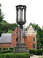 the pillory and the Bailli House
 -
 Moulin banal (mill)
 -
 The Binchfort farm (16th century)


References
- ^ "Wettelijke Bevolking per gemeente op 1 januari 2018". Statbel. Retrieved 9 March 2019.
External links
-
 Media related to
Braine-le-Château at Wikimedia Commons
Media related to
Braine-le-Château at Wikimedia Commons - Official website
Places adjacent to Braine-le-Château | ||||||||||||||||
|---|---|---|---|---|---|---|---|---|---|---|---|---|---|---|---|---|
| ||||||||||||||||

| International | |
|---|---|
| Geographic | |
|
| This Walloon Brabant location article is a stub. You can help Wikipedia by expanding it. |
Braine-le-Château | |
|---|---|
|
Braine-le-Château: the castle | |
|
Flag Coat of arms | |
Braine-le-Château Location in Belgium
The municipality of Braine-le-Château in Walloon Brabant | |
| Coordinates: 50°41′N 04°16′E / 50.683°N 4.267°E | |
| Country | |
| Community | French Community |
| Region | Wallonia |
| Province | Walloon Brabant |
| Arrondissement | Nivelles |
| Government | |
| • Mayor | Nicolas Tamigniau (RB) |
| • Governing party/ies | Renouveau Brainois (RB) |
| Area | |
| • Total | 22.75 km2 (8.78 sq mi) |
| Population (2018-01-01)
[1] | |
| • Total | 10,447 |
| • Density | 460/km2 (1,200/sq mi) |
| Postal codes | 1440 |
| NIS code | 25015 |
| Area codes | 02 |
| Website | www.braine-le-chateau.be |
Braine-le-Château (French pronunciation: [bʁɛn lə ʃato] ⓘ; Walloon: Brinne-Tchestea; Dutch: Kasteelbrakel, Dutch pronunciation: [kɑˈsteːlˌbraːkəl]) is a municipality of Wallonia located in the Belgian province of Walloon Brabant.
On January 1, 2006, Braine-le-Château had a total population of 9,446. The total area is 22.70 km² which gives a population density of 416 inhabitants per km².
The municipality consists of the following districts: Braine-le-Château and Wauthier-Braine, which were municipalities of their own until 1977.
Braine-le-Château is a medieval village in which remain many buildings from the Middle Ages. Among them are the pillory (1521), the village mill (c. 1200) and the Maison du Bailli (c. 1535).
-
the pillory and the Bailli House
-
Moulin banal (mill)
-
The Binchfort farm (16th century)
References
- ^ "Wettelijke Bevolking per gemeente op 1 januari 2018". Statbel. Retrieved 9 March 2019.
External links
-
Media related to
Braine-le-Château at Wikimedia Commons
- Official website
Places adjacent to Braine-le-Château | ||||||||||||||||
|---|---|---|---|---|---|---|---|---|---|---|---|---|---|---|---|---|
| ||||||||||||||||
| International | |
|---|---|
| Geographic | |
|
| This Walloon Brabant location article is a stub. You can help Wikipedia by expanding it. |