Photos • Location
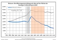
Development of Population since 1875 within the Current Boundaries (Blue Line: Population; Dotted Line: Comparison to Population Development of Brandenburg state; Grey Background: Time of Nazi rule; Red Background: Time of Communist rule)


This article needs additional citations for
verification. (December 2008) |
Brüssow | |
|---|---|
Location of Brüssow within Uckermark district  | |
 Brüssow  Brüssow | |
| Coordinates: 53°24′N 14°08′E / 53.400°N 14.133°E | |
| Country | Germany |
| State | Brandenburg |
| District | Uckermark |
| Municipal assoc. | Brüssow (Uckermark) |
| Government | |
| • Mayor (2019–24) | Michael Rakow [1] |
| Area | |
| • Total | 101.02 km2 (39.00 sq mi) |
| Elevation | 55 m (180 ft) |
| Population (2022-12-31)
[2] | |
| • Total | 1,827 |
| • Density | 18/km2 (47/sq mi) |
| Time zone | UTC+01:00 ( CET) |
| • Summer ( DST) | UTC+02:00 ( CEST) |
| Postal codes | 17326 |
| Dialling codes | 039742 |
| Vehicle registration | UM |
| Website | www.amt-bruessow.de |
Brüssow is a town in the Uckermark district, in Brandenburg, Germany. It is situated 16 km southeast of Pasewalk, and 27 km west of Szczecin.
Demography
|
|
|
References
- ^ Landkreis Uckermark Wahl der Bürgermeisterin / des Bürgermeisters, accessed 4 July 2021.
- ^ "Bevölkerungsentwicklung und Bevölkerungsstandim Land Brandenburg Dezember 2022" (PDF). Amt für Statistik Berlin-Brandenburg (in German). June 2023.
- ^ Detailed data sources are to be found in the Wikimedia Commons. Population Projection Brandenburg at Wikimedia Commons
Towns and municipalities in
Uckermark | ||
|---|---|---|
|  | |
Wikimedia Commons has media related to
Brüssow.
| International | |
|---|---|
| National | |
|
| This Brandenburg location article is a stub. You can help Wikipedia by expanding it. |
This article needs additional citations for
verification. (December 2008) |
Brüssow | |
|---|---|
Location of Brüssow within Uckermark district | |
Brüssow Brüssow | |
| Coordinates: 53°24′N 14°08′E / 53.400°N 14.133°E | |
| Country | Germany |
| State | Brandenburg |
| District | Uckermark |
| Municipal assoc. | Brüssow (Uckermark) |
| Government | |
| • Mayor (2019–24) | Michael Rakow [1] |
| Area | |
| • Total | 101.02 km2 (39.00 sq mi) |
| Elevation | 55 m (180 ft) |
| Population (2022-12-31)
[2] | |
| • Total | 1,827 |
| • Density | 18/km2 (47/sq mi) |
| Time zone | UTC+01:00 ( CET) |
| • Summer ( DST) | UTC+02:00 ( CEST) |
| Postal codes | 17326 |
| Dialling codes | 039742 |
| Vehicle registration | UM |
| Website | www.amt-bruessow.de |
Brüssow is a town in the Uckermark district, in Brandenburg, Germany. It is situated 16 km southeast of Pasewalk, and 27 km west of Szczecin.
Demography
|
|
|
References
- ^ Landkreis Uckermark Wahl der Bürgermeisterin / des Bürgermeisters, accessed 4 July 2021.
- ^ "Bevölkerungsentwicklung und Bevölkerungsstandim Land Brandenburg Dezember 2022" (PDF). Amt für Statistik Berlin-Brandenburg (in German). June 2023.
- ^ Detailed data sources are to be found in the Wikimedia Commons. Population Projection Brandenburg at Wikimedia Commons
Towns and municipalities in
Uckermark | ||
|---|---|---|
| | |
Wikimedia Commons has media related to
Brüssow.
| International | |
|---|---|
| National | |
|
| This Brandenburg location article is a stub. You can help Wikipedia by expanding it. |