Boyes, Montana | |
|---|---|
| Coordinates: 45°16′5″N 105°1′52″W / 45.26806°N 105.03111°W | |
| Country | United States |
| State | Montana |
| County | Carter |
| Elevation | 3,327 ft (1,014 m) |
| Time zone | Mountain (MST) |
| • Summer ( DST) | MDT |
| Area code | 406 |
| GNIS feature ID | 802052 [1] |
Boyes is an unincorporated village in southwestern Carter County, Montana, United States. It lies along U.S. Route 212 southwest of the town of Ekalaka, the county seat of Carter County. [2] Its elevation is 3,327 feet (1,014 m) and it is located at 45°16′5″N 105°1′52″W / 45.26806°N 105.03111°W. [1]
The town was named after Henry Edward Boyes, an early homesteader and stagecoach driver who stopped off to change horses. [3] The town was originally located at the head of Scott Creek. In 1931, it was moved to be closer to U.S. Route 212. [3] A post office, established in 1906, [4] is still in operation serving ZIP code 59316. [5]
References
- ^ a b c U.S. Geological Survey Geographic Names Information System: Boyes, Montana
- ^ Rand McNally. The Road Atlas '08. Chicago: Rand McNally, 2008, p. 61.
- ^ a b "Montana Place Names Companion". Montana Historical Society. Retrieved July 25, 2017.
- ^ Carkeek Cheney, Roberta (1983). Names on the Face of Montana. Missoula, Montana: Mountain Press Publishing Company. p. 5. ISBN 0-87842-150-5.
- ^ Zip Code Lookup Archived June 15, 2011, at the Wayback Machine
Municipalities and communities of
Carter County, Montana, United States | ||
|---|---|---|
| Town | 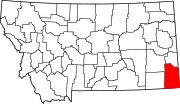 | |
| CDP | ||
|
Other communities | ||
| Indian reservation | ||
| Footnotes | ‡This populated place also has portions in an adjacent county or counties | |
|
| This Carter County, Montana state location article is a stub. You can help Wikipedia by expanding it. |
Boyes, Montana | |
|---|---|
| Coordinates: 45°16′5″N 105°1′52″W / 45.26806°N 105.03111°W | |
| Country | United States |
| State | Montana |
| County | Carter |
| Elevation | 3,327 ft (1,014 m) |
| Time zone | Mountain (MST) |
| • Summer ( DST) | MDT |
| Area code | 406 |
| GNIS feature ID | 802052 [1] |
Boyes is an unincorporated village in southwestern Carter County, Montana, United States. It lies along U.S. Route 212 southwest of the town of Ekalaka, the county seat of Carter County. [2] Its elevation is 3,327 feet (1,014 m) and it is located at 45°16′5″N 105°1′52″W / 45.26806°N 105.03111°W. [1]
The town was named after Henry Edward Boyes, an early homesteader and stagecoach driver who stopped off to change horses. [3] The town was originally located at the head of Scott Creek. In 1931, it was moved to be closer to U.S. Route 212. [3] A post office, established in 1906, [4] is still in operation serving ZIP code 59316. [5]
References
- ^ a b c U.S. Geological Survey Geographic Names Information System: Boyes, Montana
- ^ Rand McNally. The Road Atlas '08. Chicago: Rand McNally, 2008, p. 61.
- ^ a b "Montana Place Names Companion". Montana Historical Society. Retrieved July 25, 2017.
- ^ Carkeek Cheney, Roberta (1983). Names on the Face of Montana. Missoula, Montana: Mountain Press Publishing Company. p. 5. ISBN 0-87842-150-5.
- ^ Zip Code Lookup Archived June 15, 2011, at the Wayback Machine
Municipalities and communities of
Carter County, Montana, United States | ||
|---|---|---|
| Town | | |
| CDP | ||
|
Other communities | ||
| Indian reservation | ||
| Footnotes | ‡This populated place also has portions in an adjacent county or counties | |
|
| This Carter County, Montana state location article is a stub. You can help Wikipedia by expanding it. |