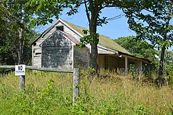
Bowyer-Holladay House | |
 Western side of the house | |
| Location | US 220, Fincastle, Virginia |
|---|---|
| Coordinates | 37°26′19″N 79°54′24″W / 37.43861°N 79.90667°W |
| Area | 17 acres (6.9 ha) |
| Built | c. 1830 |
| NRHP reference No. | 99000704 [1] |
| VLR No. | 011-0028 |
| Significant dates | |
| Added to NRHP | June 10, 1999 |
| Designated VLR | March 17, 1999 [2] |
Bowyer-Holladay House, also known as the Lewis Holladay House, is a historic archaeological site located near Fincastle, Botetourt County, Virginia. The site is located in The Botetourt Center at Greenfield industrial park. The site consists of the ruins of an Early Republic/Federal Style two-story brick house with a limestone lined cellar in a rear-centered ell configuration. The house was part of the plantation complex commonly referred to as the "Holladay Place." In addition to the ruins of the main house, a log structure with an early timber and modern frame addition survives 25 feet north of the bulkhead entrance to the limestone cellar. [3]
It was listed on the National Register of Historic Places in 2010. [1]
References
- ^ a b "National Register Information System". National Register of Historic Places. National Park Service. July 9, 2010.
- ^ "Virginia Landmarks Register". Virginia Department of Historic Resources. Archived from the original on September 21, 2013. Retrieved June 5, 2013.
- ^ Randy Jones (December 29, 2009). "The 'Holladay/ Bowyer House' National Register Site, Botetourt County, Virginia, Located in The Botetourt Center at Greenfield". Department of Historic Resources. Archived from the original on February 7, 2006.
Bowyer-Holladay House | |
 Western side of the house | |
| Location | US 220, Fincastle, Virginia |
|---|---|
| Coordinates | 37°26′19″N 79°54′24″W / 37.43861°N 79.90667°W |
| Area | 17 acres (6.9 ha) |
| Built | c. 1830 |
| NRHP reference No. | 99000704 [1] |
| VLR No. | 011-0028 |
| Significant dates | |
| Added to NRHP | June 10, 1999 |
| Designated VLR | March 17, 1999 [2] |
Bowyer-Holladay House, also known as the Lewis Holladay House, is a historic archaeological site located near Fincastle, Botetourt County, Virginia. The site is located in The Botetourt Center at Greenfield industrial park. The site consists of the ruins of an Early Republic/Federal Style two-story brick house with a limestone lined cellar in a rear-centered ell configuration. The house was part of the plantation complex commonly referred to as the "Holladay Place." In addition to the ruins of the main house, a log structure with an early timber and modern frame addition survives 25 feet north of the bulkhead entrance to the limestone cellar. [3]
It was listed on the National Register of Historic Places in 2010. [1]
References
- ^ a b "National Register Information System". National Register of Historic Places. National Park Service. July 9, 2010.
- ^ "Virginia Landmarks Register". Virginia Department of Historic Resources. Archived from the original on September 21, 2013. Retrieved June 5, 2013.
- ^ Randy Jones (December 29, 2009). "The 'Holladay/ Bowyer House' National Register Site, Botetourt County, Virginia, Located in The Botetourt Center at Greenfield". Department of Historic Resources. Archived from the original on February 7, 2006.


