Photos • Location
Botou | |
|---|---|
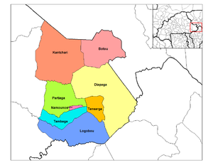
 Diapaga Department location in the province | |
| Country | |
| Province | Tapoa Province |
| Area | |
| • Total | 690 sq mi (1,787 km2) |
| Population (2019 census)
[1] | |
| • Total | 81,128 |
| • Density | 120/sq mi (45/km2) |
| Time zone | UTC+0 (GMT 0) |
Botou is a department or commune of Tapoa Province in eastern Burkina Faso. Its capital is the town of Botou. [2] The department constitutes a panhandle that stretches into Niger.
|
| This section is empty. You can help by
adding to it. (April 2015) |
- ^ Citypopulation.de Population of provinces in Est Region
- ^ "Région du Sahel". www.inforoute-communale.gov.bf. Archived from the original on 2016-12-31. Retrieved 2016-06-20.
12°39′45″N 2°03′28″E / 12.6624°N 2.0579°E
Botou | |
|---|---|
 Diapaga Department location in the province | |
| Country | |
| Province | Tapoa Province |
| Area | |
| • Total | 690 sq mi (1,787 km2) |
| Population (2019 census)
[1] | |
| • Total | 81,128 |
| • Density | 120/sq mi (45/km2) |
| Time zone | UTC+0 (GMT 0) |
Botou is a department or commune of Tapoa Province in eastern Burkina Faso. Its capital is the town of Botou. [2] The department constitutes a panhandle that stretches into Niger.
|
| This section is empty. You can help by
adding to it. (April 2015) |
- ^ Citypopulation.de Population of provinces in Est Region
- ^ "Région du Sahel". www.inforoute-communale.gov.bf. Archived from the original on 2016-12-31. Retrieved 2016-06-20.
12°39′45″N 2°03′28″E / 12.6624°N 2.0579°E