Photos • Location

| Bostock | |
|---|---|
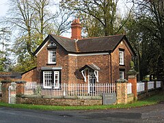
 Middle Lodge, Bostock Hall | |
Location within
Cheshire | |
| OS grid reference | SJ673688 |
| Civil parish |
|
| Unitary authority | |
| Ceremonial county | |
| Region | |
| Country | England |
| Sovereign state | United Kingdom |
| Post town | MIDDLEWICH |
| Postcode district | CW10 |
| Dialling code | 01606 |
| Police | Cheshire |
| Fire | Cheshire |
| Ambulance | North West |
| UK Parliament | |
Bostock is a village and civil parish in the unitary authority of Cheshire West and Chester and the ceremonial county of Cheshire, England. [1] According to the 2001 census it had a population of 229, reducing slightly to 225 at the 2011 Census. [2] The village is between the towns of Winsford and Northwich.
See also
References
- ^ Ordnance Survey: Landranger map sheet 118 Stoke-on-Trent & Macclesfield (Map). Ordnance Survey. 2012. ISBN 9780319229064.
- ^ "Parish population 2011". Retrieved 31 May 2015.
External links
Wikimedia Commons has media related to
Bostock.
| Bostock | |
|---|---|
 Middle Lodge, Bostock Hall | |
Location within
Cheshire | |
| OS grid reference | SJ673688 |
| Civil parish |
|
| Unitary authority | |
| Ceremonial county | |
| Region | |
| Country | England |
| Sovereign state | United Kingdom |
| Post town | MIDDLEWICH |
| Postcode district | CW10 |
| Dialling code | 01606 |
| Police | Cheshire |
| Fire | Cheshire |
| Ambulance | North West |
| UK Parliament | |
Bostock is a village and civil parish in the unitary authority of Cheshire West and Chester and the ceremonial county of Cheshire, England. [1] According to the 2001 census it had a population of 229, reducing slightly to 225 at the 2011 Census. [2] The village is between the towns of Winsford and Northwich.
See also
References
- ^ Ordnance Survey: Landranger map sheet 118 Stoke-on-Trent & Macclesfield (Map). Ordnance Survey. 2012. ISBN 9780319229064.
- ^ "Parish population 2011". Retrieved 31 May 2015.
External links
Wikimedia Commons has media related to
Bostock.
