-
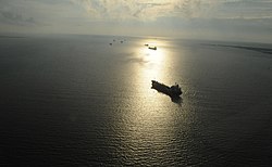
 Southern aerial view of Bolivar Roads
 -
 Bolivar Roads partition of Bolivar Peninsula and Galveston Island
 -
 Maritime vessels at Galveston Island seacoast
 -
 Maritime navigation to Bolivar Roads
 -
 Ships approaching Bolivar Roads and Galveston Bay
 -
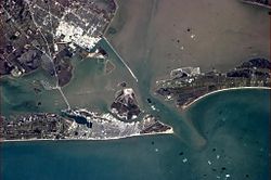 Geographic view of Bolivar Roads
 -

Photos • Location

| Bolivar Roads | |
|---|---|
 | |
 Illustration of Bolivar Roads to Galveston Bay | |
 Galveston Bay Entrance Channel | |
| Location |
|
| Country | United States |
| Coordinates | 29°21′02″N 94°45′10″W / 29.35051°N 94.75269°W |
| Specifications | |
| Length | 11.2 km (7.0 miles) (originally 42.2 km or 26.2 mi) ( Morgan's Point [1]) |
| Navigation authority | |
| Jetty Harbor System |
|
| History | |
| Former names |
|
| Modern name | Doorway to Galveston Bay |
| Current owner | State of Texas |
| Topo Map | Bolivar Roads (Map). |
| Geography | |
| Direction | North |
| Start point | Texas Gulf Coast |
| End point | Texas City Dike |
| Beginning coordinates | 29°20′05″N 94°41′18″W / 29.334835°N 94.688394°W |
| Ending coordinates | 29°21′46″N 94°47′59″W / 29.362688°N 94.799633°W |
| Branch(es) | |
| Branch of |
|
| Connects to | |
| GNIS feature ID | |
Bolivar Roads is a natural navigable strait fringed by Bolivar Peninsula and Galveston Island emerging as a landform on the Texas Gulf Coast. [4] The natural waterway inlet has a depth of 45 feet (14 m) with an island to peninsula shoreline width of 1.5 miles (2.4 km).
The ship canal approach is defined by two jetties extending into the Gulf of Mexico with distances of 4.5 miles (7.2 km) from the Bolivar Peninsula and 2.25 miles (3.62 km) from Galveston Island. The jetty harbor entrance originated in the 1890s as a preventative structure to inhibit the coastal sediment transport progressions by means of deviations with the continental margin and the Gulf Stream ocean current.
The Bolivar Roads channel tailors a nautical navigation gateway for Galveston Bay, Houston Ship Channel, Port of Galveston, and West Bay.
Gallery
Depictions of Bolivar Roads at Bolivar Peninsula and Galveston Island


.jpg)
See also
- Aframax
- Bolivar Bridge
- Cargo Ship Capacity
- List of Panamax ports
- Panamax
- United States Maritime Environmental Law
References
- ^ "Dimensions of the HSC, Tributary Channels, and Turning Basins" [Houston Ship Channel Feasibility: Houston-Galveston Navigation Channels, Texas] (PDF). U.S. Army Corps of Engineers. October 28, 2019. p. 10.
- ^ Bolivar Roads Channel in Geonames.org (cc-by)
- ^ Houston/Galveston Navigation Channel in Geonames.org (cc-by)
- ^ Bolivar Roads in Geonames.org (cc-by)
- ^ Shuttle Replica On The Way To Space Center Houston on YouTube
- ^ Space Shuttle Enterprise in Galveston Bay on YouTube
External links
- Anonymous. "Bolivar Roads". Handbook of Texas Online. Texas State Historical Association.
- Anonymous. "Ocean Shipping". Handbook of Texas Online. Texas State Historical Association.
- "Bolivar Roads Anchorage". AIS Ports. MarineTraffic.
- "§ 110.197 - Galveston Harbor, Bolivar Roads Channel, Texas" [Title 33, Chapter I, Subchapter I, Part 110]. Code of Federal Regulations.
- "NOAA Nautical Chart 11323" [Approaches to Galveston Bay]. NOAA Office of Coast Survey. National Oceanic and Atmospheric Administration.
- "NOAA Nautical Chart 11324" [Galveston Bay Entrance]. NOAA Office of Coast Survey. National Oceanic and Atmospheric Administration.
- "NOAA Nautical Chart 11326" [Galveston Bay, Texas]. NOAA Office of Coast Survey. National Oceanic and Atmospheric Administration.
| Bolivar Roads | |
|---|---|
|
| |
|
Illustration of Bolivar Roads to Galveston Bay | |
Galveston Bay Entrance Channel | |
| Location |
|
| Country | United States |
| Coordinates | 29°21′02″N 94°45′10″W / 29.35051°N 94.75269°W |
| Specifications | |
| Length | 11.2 km (7.0 miles) (originally 42.2 km or 26.2 mi) ( Morgan's Point [1]) |
| Navigation authority | |
| Jetty Harbor System |
|
| History | |
| Former names |
|
| Modern name | Doorway to Galveston Bay |
| Current owner | State of Texas |
| Topo Map | Bolivar Roads (Map). |
| Geography | |
| Direction | North |
| Start point | Texas Gulf Coast |
| End point | Texas City Dike |
| Beginning coordinates | 29°20′05″N 94°41′18″W / 29.334835°N 94.688394°W |
| Ending coordinates | 29°21′46″N 94°47′59″W / 29.362688°N 94.799633°W |
| Branch(es) | |
| Branch of |
|
| Connects to | |
| GNIS feature ID | |
Bolivar Roads is a natural navigable strait fringed by Bolivar Peninsula and Galveston Island emerging as a landform on the Texas Gulf Coast. [4] The natural waterway inlet has a depth of 45 feet (14 m) with an island to peninsula shoreline width of 1.5 miles (2.4 km).
The ship canal approach is defined by two jetties extending into the Gulf of Mexico with distances of 4.5 miles (7.2 km) from the Bolivar Peninsula and 2.25 miles (3.62 km) from Galveston Island. The jetty harbor entrance originated in the 1890s as a preventative structure to inhibit the coastal sediment transport progressions by means of deviations with the continental margin and the Gulf Stream ocean current.
The Bolivar Roads channel tailors a nautical navigation gateway for Galveston Bay, Houston Ship Channel, Port of Galveston, and West Bay.
Gallery
Depictions of Bolivar Roads at Bolivar Peninsula and Galveston Island
-
Southern aerial view of Bolivar Roads
-
Bolivar Roads partition of Bolivar Peninsula and Galveston Island
-
Maritime vessels at Galveston Island seacoast
-
Maritime navigation to Bolivar Roads
-
Ships approaching Bolivar Roads and Galveston Bay
-
Geographic view of Bolivar Roads
-
See also
- Aframax
- Bolivar Bridge
- Cargo Ship Capacity
- List of Panamax ports
- Panamax
- United States Maritime Environmental Law
References
- ^ "Dimensions of the HSC, Tributary Channels, and Turning Basins" [Houston Ship Channel Feasibility: Houston-Galveston Navigation Channels, Texas] (PDF). U.S. Army Corps of Engineers. October 28, 2019. p. 10.
- ^ Bolivar Roads Channel in Geonames.org (cc-by)
- ^ Houston/Galveston Navigation Channel in Geonames.org (cc-by)
- ^ Bolivar Roads in Geonames.org (cc-by)
- ^ Shuttle Replica On The Way To Space Center Houston on YouTube
- ^ Space Shuttle Enterprise in Galveston Bay on YouTube
External links
- Anonymous. "Bolivar Roads". Handbook of Texas Online. Texas State Historical Association.
- Anonymous. "Ocean Shipping". Handbook of Texas Online. Texas State Historical Association.
- "Bolivar Roads Anchorage". AIS Ports. MarineTraffic.
- "§ 110.197 - Galveston Harbor, Bolivar Roads Channel, Texas" [Title 33, Chapter I, Subchapter I, Part 110]. Code of Federal Regulations.
- "NOAA Nautical Chart 11323" [Approaches to Galveston Bay]. NOAA Office of Coast Survey. National Oceanic and Atmospheric Administration.
- "NOAA Nautical Chart 11324" [Galveston Bay Entrance]. NOAA Office of Coast Survey. National Oceanic and Atmospheric Administration.
- "NOAA Nautical Chart 11326" [Galveston Bay, Texas]. NOAA Office of Coast Survey. National Oceanic and Atmospheric Administration.
| |||||||||||||||||||||||||||||