Photos • Location
This article relies largely or entirely on a
single source. (March 2022) |
Bogogobo | |
|---|---|
Village | |
| Coordinates: 26°39′42″S 21°55′50″E / 26.66167°S 21.93056°E | |
| Country | |
| District | Kgalagadi District |
| Population (2011) | |
| • Total | 360 |
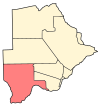
Bogogobo is a village in the Kgalagadi District of Botswana. It is located near the border with South Africa and has a primary school. The population was 360 in 2011 census. [1]
Demographics
According to 2011 census the village population was 360.
References
- ^ "2011 Botswana Population and Housing Census" (PDF). Retrieved 11 September 2013.
26°39′42″S 21°55′50″E / 26.66167°S 21.93056°E

