| Bluerock Creek | |
|---|---|
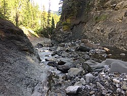
 The deep gorge of Bluerock Creek | |
| Location | |
| Country | Canada |
| Province | Alberta |
| Physical characteristics | |
| Source | |
| • location | Rocky Mountains |
| Mouth | |
• location | Sheep River |
• coordinates | 50°36′27″N 114°43′40″W / 50.6074°N 114.7277°W |
| Length | 11.4 km (7.1 mi) |
Bluerock Creek is a creek located in southern Alberta, Canada. It is a tributary of the Sheep River, which itself is a tributary of the Highwood River. The creek runs for 11.4 km from its source in the foothills of the Rocky Mountains to its confluence with the Sheep River. [1]
History
Bluerock Creek's steep canyon walls were created by glacial forces during the last ice age. Logging in and around the Sheep River began in the early 1900s, around the same time nearby Turner Valley was settled. After several decades of sporadic and rather unprofitable logging, the last of these sawmills closed in 1955. [2]
Recreation
Bluerock Campground is located nearby. With 66 sites, the campground is also the trailhead of the Bluerock Creek Trail, which straddles the creek's left side.
See also
References
- ^ "Index of /Pub/Nrcan_rncan/Vector/Canvec/SHP/Hydro".
- ^ "Bluerock Creek Trail Pamphlet" (PDF). Alberta Parks. Retrieved 14 July 2017.
| Bluerock Creek | |
|---|---|
 The deep gorge of Bluerock Creek | |
| Location | |
| Country | Canada |
| Province | Alberta |
| Physical characteristics | |
| Source | |
| • location | Rocky Mountains |
| Mouth | |
• location | Sheep River |
• coordinates | 50°36′27″N 114°43′40″W / 50.6074°N 114.7277°W |
| Length | 11.4 km (7.1 mi) |
Bluerock Creek is a creek located in southern Alberta, Canada. It is a tributary of the Sheep River, which itself is a tributary of the Highwood River. The creek runs for 11.4 km from its source in the foothills of the Rocky Mountains to its confluence with the Sheep River. [1]
History
Bluerock Creek's steep canyon walls were created by glacial forces during the last ice age. Logging in and around the Sheep River began in the early 1900s, around the same time nearby Turner Valley was settled. After several decades of sporadic and rather unprofitable logging, the last of these sawmills closed in 1955. [2]
Recreation
Bluerock Campground is located nearby. With 66 sites, the campground is also the trailhead of the Bluerock Creek Trail, which straddles the creek's left side.
See also
References
- ^ "Index of /Pub/Nrcan_rncan/Vector/Canvec/SHP/Hydro".
- ^ "Bluerock Creek Trail Pamphlet" (PDF). Alberta Parks. Retrieved 14 July 2017.