This article relies largely or entirely on a
single source. (July 2017) |
| Biggar Water | |
|---|---|
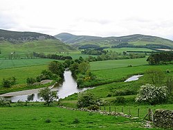
 Confluence of the Biggar Water and Tweed | |
| Location | |
| Country | Scotland, United Kingdom |
| Council area | South Lanarkshire |
| OS grid reference | NT045375 |
| Physical characteristics | |
| Mouth | Confluence with the River Tweed |
• coordinates | 55°36′11″N 3°22′38″W / 55.603074°N 3.377176°W |
Biggar Water is a river in Lanarkshire and Peeblesshire, in the Southern Uplands of Scotland.
It forms part of the River Tweed system. It rises, as Biggar Burn, in the north-east of the parish of Biggar, South Lanarkshire and flows about 6+3⁄4 miles (10.9 km) generally south-westerly toward the town of Biggar, where it becomes Biggar Water. It then flows about 5 miles (8.0 km) eastwards before its confluence with the Tweed 3⁄4 mile (1.2 km) mile north-east of Drumelzier in Peeblesshire. [1]
- ^ Ordnance Gazetteer of Scotland, by Francis Groome, 2nd edition 1896; article on Skirling
This article relies largely or entirely on a
single source. (July 2017) |
| Biggar Water | |
|---|---|
 Confluence of the Biggar Water and Tweed | |
| Location | |
| Country | Scotland, United Kingdom |
| Council area | South Lanarkshire |
| OS grid reference | NT045375 |
| Physical characteristics | |
| Mouth | Confluence with the River Tweed |
• coordinates | 55°36′11″N 3°22′38″W / 55.603074°N 3.377176°W |
Biggar Water is a river in Lanarkshire and Peeblesshire, in the Southern Uplands of Scotland.
It forms part of the River Tweed system. It rises, as Biggar Burn, in the north-east of the parish of Biggar, South Lanarkshire and flows about 6+3⁄4 miles (10.9 km) generally south-westerly toward the town of Biggar, where it becomes Biggar Water. It then flows about 5 miles (8.0 km) eastwards before its confluence with the Tweed 3⁄4 mile (1.2 km) mile north-east of Drumelzier in Peeblesshire. [1]
- ^ Ordnance Gazetteer of Scotland, by Francis Groome, 2nd edition 1896; article on Skirling
