| Big Sandy Creek | |
|---|---|
 | |
|
| |
| Location | |
| Country | United States |
| State | Texas |
| Physical characteristics | |
| Source | |
| • location | Central Polk County, Southeast of the community of Moscow |
| • coordinates | 30°52′23″N 94°47′44″W / 30.87306°N 94.79556°W |
| Mouth | |
• location | Village Creek outside of Village Mills, Hardin County |
• coordinates | 30°30′08″N 94°26′03″W / 30.50222°N 94.43417°W |
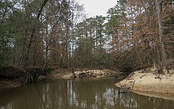
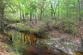
Big Sandy Creek is a stream in Texas, United States. It rises in Polk County before flowing approximately 40 miles (64 km) southeast into Hardin County where it merges with Kimball Creek, forming Village Creek. [1] [2] Long sections of the creek pass through the Big Thicket National Preserve. The 14,343 acres (58.04 km2) Big Sandy Creek unit is named after the stream. [3] The creek also passes through the Alabama-Coushatta Reservation reservation east of Livingston. [1]
Ecology and wildlife
Bottomland hardwood forests and beech-magnolia-loblolly slope forests can be found in the stream's floodplain, while pine savannas occupy the adjacent uplands. [3] [4] Common tree species seen in the bottomlands include sweetgum ( Liquidambar styraciflua), swamp chestnut oak ( Quercus michauxii), hornbeam ( Carpinus caroliniana), Hollies ( Ilex sp.), and bald cypress ( Taxodium distichum). [4]
Outside of the national preserve, the Alabama-Coushatta people manage and protect longleaf pine ecosystems on their land. Prescribed fire and reforestation efforts protect greater than 400 acres (1.6 km2) of forest dominated by Longleaf Pine ( Pinus palustris), an important cultural symbol used in basket weaving. [5] [6]

See also
References
- "An Analysis of Texas Waterways". Archived from the original on 3 May 2006. Retrieved 2006-05-04.
- USGS Geographic Names Information Service
- USGS Hydrologic Unit Map - State of Texas (1974)
- ^ a b "TSHA | Big Sandy Creek (Polk County)". www.tshaonline.org. Retrieved 2022-11-13.
- ^ "TPWD: An Analysis of Texas Waterways (PWD RP T3200-1047) -- Seasonal and Restrictive Waterways of East Texas, Part 1". tpwd.texas.gov. Retrieved 2022-11-13.
- ^ a b "Big Sandy Creek Unit - Big Thicket National Preserve (U.S. National Park Service)". www.nps.gov. National Park Service. Retrieved 2022-11-13.
- ^ a b "Big Sandy Loop — Texas Parks & Wildlife Department". tpwd.texas.gov. Retrieved 2022-11-13.
- ^ Moseley, Beverly (21 February 2017). "Alabama-Coushatta Tribe of Texas Begins Longleaf Pine Restoration Efforts". www.usda.gov. Retrieved 2022-11-13.
- ^ "Ensuring a Legacy of Longleaf". The Nature Conservancy. 30 March 2022. Retrieved 2022-11-13.
| Big Sandy Creek | |
|---|---|
 | |
|
| |
| Location | |
| Country | United States |
| State | Texas |
| Physical characteristics | |
| Source | |
| • location | Central Polk County, Southeast of the community of Moscow |
| • coordinates | 30°52′23″N 94°47′44″W / 30.87306°N 94.79556°W |
| Mouth | |
• location | Village Creek outside of Village Mills, Hardin County |
• coordinates | 30°30′08″N 94°26′03″W / 30.50222°N 94.43417°W |
Big Sandy Creek is a stream in Texas, United States. It rises in Polk County before flowing approximately 40 miles (64 km) southeast into Hardin County where it merges with Kimball Creek, forming Village Creek. [1] [2] Long sections of the creek pass through the Big Thicket National Preserve. The 14,343 acres (58.04 km2) Big Sandy Creek unit is named after the stream. [3] The creek also passes through the Alabama-Coushatta Reservation reservation east of Livingston. [1]
Ecology and wildlife
Bottomland hardwood forests and beech-magnolia-loblolly slope forests can be found in the stream's floodplain, while pine savannas occupy the adjacent uplands. [3] [4] Common tree species seen in the bottomlands include sweetgum ( Liquidambar styraciflua), swamp chestnut oak ( Quercus michauxii), hornbeam ( Carpinus caroliniana), Hollies ( Ilex sp.), and bald cypress ( Taxodium distichum). [4]
Outside of the national preserve, the Alabama-Coushatta people manage and protect longleaf pine ecosystems on their land. Prescribed fire and reforestation efforts protect greater than 400 acres (1.6 km2) of forest dominated by Longleaf Pine ( Pinus palustris), an important cultural symbol used in basket weaving. [5] [6]

See also
References
- "An Analysis of Texas Waterways". Archived from the original on 3 May 2006. Retrieved 2006-05-04.
- USGS Geographic Names Information Service
- USGS Hydrologic Unit Map - State of Texas (1974)
- ^ a b "TSHA | Big Sandy Creek (Polk County)". www.tshaonline.org. Retrieved 2022-11-13.
- ^ "TPWD: An Analysis of Texas Waterways (PWD RP T3200-1047) -- Seasonal and Restrictive Waterways of East Texas, Part 1". tpwd.texas.gov. Retrieved 2022-11-13.
- ^ a b "Big Sandy Creek Unit - Big Thicket National Preserve (U.S. National Park Service)". www.nps.gov. National Park Service. Retrieved 2022-11-13.
- ^ a b "Big Sandy Loop — Texas Parks & Wildlife Department". tpwd.texas.gov. Retrieved 2022-11-13.
- ^ Moseley, Beverly (21 February 2017). "Alabama-Coushatta Tribe of Texas Begins Longleaf Pine Restoration Efforts". www.usda.gov. Retrieved 2022-11-13.
- ^ "Ensuring a Legacy of Longleaf". The Nature Conservancy. 30 March 2022. Retrieved 2022-11-13.