This article has multiple issues. Please help
improve it or discuss these issues on the
talk page. (
Learn how and when to remove these template messages)
|
Berettyóújfalu District
Berettyóújfalui járás | |
|---|---|
 Coat of arms | |
 Berettyóújfalu District within Hungary and Hajdú-Bihar County. | |
| Country | |
| County | Hajdú-Bihar |
| District seat | Berettyóújfalu |
| Area | |
| • Total | 1,073.90 km2 (414.64 sq mi) |
| • Rank | 1st in Hajdú-Bihar |
| Population (2011 census) | |
| • Total | 44,995 |
| • Rank | 2nd in Hajdú-Bihar |
| • Density | 42/km2 (110/sq mi) |
Berettyóújfalu ( Hungarian: Berettyóújfalui járás) is a district in south-eastern part of Hajdú-Bihar County. Berettyóújfalu is also the name of the town where the district seat is found. The district is located in the Northern Great Plain Statistical Region. This district is a part of Bihar historical and geographical region.
Geography
Berettyóújfalu District borders with Derecske District to the north, the Romanian county of Bihor to the east, Sarkad District ( Békés County) to the south, Szeghalom District (Békés County) and Püspökladány District to the west. The number of the inhabited places in Berettyóújfalu District is 25.
Municipalities
The district has 3 towns, 2 large villages and 20 villages. (ordered by population, as of 1 January 2012) [1]
- Ártánd (502)
- Bakonszeg (1,160)
- Bedő (252)
- Berekböszörmény (1,749)
- Berettyóújfalu (15,167) – district seat
- Biharkeresztes (4,149)
- Bojt (489)
- Csökmő (1,756)
- Darvas (527)
- Furta (1,136)
- Gáborján (876)
- Hencida (1,275)
- Komádi (5,172)
- Körösszakál (814)
- Körösszegapáti (882)
- Magyarhomorog (868)
- Mezőpeterd (533)
- Mezősas (591)
- Nagykereki (1,205)
- Szentpéterszeg (1,101)
- Told (310)
- Újiráz (505)
- Váncsod (1,221)
- Vekerd (112)
- Zsáka (1,544)
The bolded municipalities are cities, italics municipalities are large villages.
Demographics
Religion in Berettyóújfalu District (2011 census)
In 2011, it had a population of 44,995 and the population density was 36/km².
| Year | County population [2] | Change |
|---|---|---|
| 2011 | 44,995 | n/a |
Ethnicity
Besides the Hungarian majority, the main minorities are the Roma (approx. 3,000), Romanian (1,000) and German (200).
Total population (2011 census): 44,995
Ethnic groups (2011 census):
[3] Identified themselves: 42,143 persons:
- Hungarians: 38,009 (90.19%)
- Gypsies: 2,694 (6.39%)
- Romanians: 1,111 (2.64%)
- Others and indefinable: 329 (0.78%)
Approx. 3,000 persons in Berettyóújfalu District did not declare their ethnic group at the 2011 census.
Religion
Religious adherence in the county according to 2011 census: [4]
- Reformed – 19,399;
- Catholic – 3,480 ( Roman Catholic – 2,996; Greek Catholic – 484);
- Orthodox – 618;
- Evangelical – 86;
- other religions – 675;
- Non-religious – 9,703;
- Atheism – 262;
- Undeclared – 10,772.
Gallery
-
 Berettyóújfalu, the district seat
 -
 Rédely Mansion in Zsáka
 -
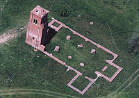 Csonkatorony from above (Herpály)
 -
 Reformed Church in Biharkeresztes

.jpg)


See also
References
- ^ A KSH 2012. évi helységnévkönyve
- ^ népesség.com, "Berettyóújfalui járás népessége"
- ^ 4.1.6.1 A népesség nemzetiség szerint, 2011, (in Hungarian) [1]
- ^ 4.1.7.1 A népesség vallás, felekezet szerint, 2011, (in Hungarian) [2]
External links
| Towns (3) |
| |
|---|---|---|
| Large villages (2) | ||
| Villages (20) | ||
47°09′00″N 21°34′00″E / 47.1500°N 21.5667°E
|
| This Hajdú-Bihar location article is a stub. You can help Wikipedia by expanding it. |
This article has multiple issues. Please help
improve it or discuss these issues on the
talk page. (
Learn how and when to remove these template messages)
|
Berettyóújfalu District
Berettyóújfalui járás | |
|---|---|
|
Coat of arms | |
|
Berettyóújfalu District within Hungary and Hajdú-Bihar County. | |
| Country | |
| County | Hajdú-Bihar |
| District seat | Berettyóújfalu |
| Area | |
| • Total | 1,073.90 km2 (414.64 sq mi) |
| • Rank | 1st in Hajdú-Bihar |
| Population (2011 census) | |
| • Total | 44,995 |
| • Rank | 2nd in Hajdú-Bihar |
| • Density | 42/km2 (110/sq mi) |
Berettyóújfalu ( Hungarian: Berettyóújfalui járás) is a district in south-eastern part of Hajdú-Bihar County. Berettyóújfalu is also the name of the town where the district seat is found. The district is located in the Northern Great Plain Statistical Region. This district is a part of Bihar historical and geographical region.
Geography
Berettyóújfalu District borders with Derecske District to the north, the Romanian county of Bihor to the east, Sarkad District ( Békés County) to the south, Szeghalom District (Békés County) and Püspökladány District to the west. The number of the inhabited places in Berettyóújfalu District is 25.
Municipalities
The district has 3 towns, 2 large villages and 20 villages. (ordered by population, as of 1 January 2012) [1]
- Ártánd (502)
- Bakonszeg (1,160)
- Bedő (252)
- Berekböszörmény (1,749)
- Berettyóújfalu (15,167) – district seat
- Biharkeresztes (4,149)
- Bojt (489)
- Csökmő (1,756)
- Darvas (527)
- Furta (1,136)
- Gáborján (876)
- Hencida (1,275)
- Komádi (5,172)
- Körösszakál (814)
- Körösszegapáti (882)
- Magyarhomorog (868)
- Mezőpeterd (533)
- Mezősas (591)
- Nagykereki (1,205)
- Szentpéterszeg (1,101)
- Told (310)
- Újiráz (505)
- Váncsod (1,221)
- Vekerd (112)
- Zsáka (1,544)
The bolded municipalities are cities, italics municipalities are large villages.
Demographics
Religion in Berettyóújfalu District (2011 census)
In 2011, it had a population of 44,995 and the population density was 36/km².
| Year | County population [2] | Change |
|---|---|---|
| 2011 | 44,995 | n/a |
Ethnicity
Besides the Hungarian majority, the main minorities are the Roma (approx. 3,000), Romanian (1,000) and German (200).
Total population (2011 census): 44,995
Ethnic groups (2011 census):
[3] Identified themselves: 42,143 persons:
- Hungarians: 38,009 (90.19%)
- Gypsies: 2,694 (6.39%)
- Romanians: 1,111 (2.64%)
- Others and indefinable: 329 (0.78%)
Approx. 3,000 persons in Berettyóújfalu District did not declare their ethnic group at the 2011 census.
Religion
Religious adherence in the county according to 2011 census: [4]
- Reformed – 19,399;
- Catholic – 3,480 ( Roman Catholic – 2,996; Greek Catholic – 484);
- Orthodox – 618;
- Evangelical – 86;
- other religions – 675;
- Non-religious – 9,703;
- Atheism – 262;
- Undeclared – 10,772.
Gallery
-
Berettyóújfalu, the district seat
-
Rédely Mansion in Zsáka
-
Csonkatorony from above (Herpály)
-
Reformed Church in Biharkeresztes
See also
References
- ^ A KSH 2012. évi helységnévkönyve
- ^ népesség.com, "Berettyóújfalui járás népessége"
- ^ 4.1.6.1 A népesség nemzetiség szerint, 2011, (in Hungarian) [1]
- ^ 4.1.7.1 A népesség vallás, felekezet szerint, 2011, (in Hungarian) [2]
External links
| Towns (3) |
| |
|---|---|---|
| Large villages (2) | ||
| Villages (20) | ||
47°09′00″N 21°34′00″E / 47.1500°N 21.5667°E
|
| This Hajdú-Bihar location article is a stub. You can help Wikipedia by expanding it. |