Photos • Location
Belleair Causeway (new) | |
|---|---|
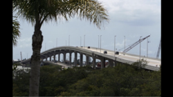
 The current Belleair Causeway bridge and the original bridge in 2009. | |
| Coordinates | 27°55′01.7″N 82°49′50.6″W / 27.917139°N 82.830722°W |
| Carries | |
| Crosses | Intracoastal Waterway |
| Locale | Belleair Beach, Florida |
| Official name | Belleair Causeway |
| Owner | County Highway Agency |
| Characteristics | |
| Design | Concrete girder bridge |
| Material | Prestressed concrete |
| Total length | 3,350 feet |
| Width | 44 feet |
| Clearance below | 72 feet |
| No. of lanes | Two |
| History | |
| Construction start | 2007 |
| Construction end | 2009 |
| Opened | 2009 |
| Statistics | |
| Toll | None |
| Location | |
|
| |
Belleair Causeway (old) | |
|---|---|
 | |
| Coordinates | 27°55′01.8″N 82°50′05.0″W / 27.917167°N 82.834722°W |
| Carries | |
| Crosses | Intracoastal Waterway |
| Locale | Belleair Beach, Florida |
| Official name | Belleair Causeway |
| Characteristics | |
| Design | Bascule |
| Material | Steel |
| Total length | 1,376 feet |
| Width | 37 feet |
| Clearance above | 20 feet |
| No. of lanes | Two |
| History | |
| Opened | 1950 |
| Closed | 2009 |
| Statistics | |
| Toll | None |
| Location | |
|
| |
The Belleair Causeway is a concrete girder bridge that crosses the Intracoastal Waterway, connecting the barrier islands of Belleair Beach and the mainland of Largo, Florida. [1] The bridge carries West Bay Drive, part of CR 416, and was built in 2009, replacing a double-leaf bascule bridge built in 1950. [2] [3] [4]
See also
- Dunedin Causeway
- Clearwater Memorial Causeway
- Sand Key Bridge
- Indian Rocks Causeway
- Park Boulevard Bridge
- Tom Stuart Causeway
- John's Pass Bridge
- Treasure Island Causeway
- Corey Causeway
- Pinellas Bayway
References
- ^ United States Coast Pilot: Atlantic Coast. Gulf of Mexico, Puerto Rico, and Virgin Islands. U.S. Government Printing Office. 2004. Retrieved October 19, 2020.
- ^ "BridgeReports.com | CR-416 (CSWY BLVD) over GULF I.C.W., Pinellas County, Florida". bridgereports.com. Retrieved 2020-10-17.
- ^ "Gulf ICWW Bridge". Bridgehunter.com. Retrieved 2020-10-17.
- ^ "Belleair Causeway Bridge". www.drawbridgeahead.com. Retrieved 2020-10-17.
Belleair Causeway (new) | |
|---|---|
 The current Belleair Causeway bridge and the original bridge in 2009. | |
| Coordinates | 27°55′01.7″N 82°49′50.6″W / 27.917139°N 82.830722°W |
| Carries | |
| Crosses | Intracoastal Waterway |
| Locale | Belleair Beach, Florida |
| Official name | Belleair Causeway |
| Owner | County Highway Agency |
| Characteristics | |
| Design | Concrete girder bridge |
| Material | Prestressed concrete |
| Total length | 3,350 feet |
| Width | 44 feet |
| Clearance below | 72 feet |
| No. of lanes | Two |
| History | |
| Construction start | 2007 |
| Construction end | 2009 |
| Opened | 2009 |
| Statistics | |
| Toll | None |
| Location | |
|
| |
Belleair Causeway (old) | |
|---|---|
 | |
| Coordinates | 27°55′01.8″N 82°50′05.0″W / 27.917167°N 82.834722°W |
| Carries | |
| Crosses | Intracoastal Waterway |
| Locale | Belleair Beach, Florida |
| Official name | Belleair Causeway |
| Characteristics | |
| Design | Bascule |
| Material | Steel |
| Total length | 1,376 feet |
| Width | 37 feet |
| Clearance above | 20 feet |
| No. of lanes | Two |
| History | |
| Opened | 1950 |
| Closed | 2009 |
| Statistics | |
| Toll | None |
| Location | |
|
| |
The Belleair Causeway is a concrete girder bridge that crosses the Intracoastal Waterway, connecting the barrier islands of Belleair Beach and the mainland of Largo, Florida. [1] The bridge carries West Bay Drive, part of CR 416, and was built in 2009, replacing a double-leaf bascule bridge built in 1950. [2] [3] [4]
See also
- Dunedin Causeway
- Clearwater Memorial Causeway
- Sand Key Bridge
- Indian Rocks Causeway
- Park Boulevard Bridge
- Tom Stuart Causeway
- John's Pass Bridge
- Treasure Island Causeway
- Corey Causeway
- Pinellas Bayway
References
- ^ United States Coast Pilot: Atlantic Coast. Gulf of Mexico, Puerto Rico, and Virgin Islands. U.S. Government Printing Office. 2004. Retrieved October 19, 2020.
- ^ "BridgeReports.com | CR-416 (CSWY BLVD) over GULF I.C.W., Pinellas County, Florida". bridgereports.com. Retrieved 2020-10-17.
- ^ "Gulf ICWW Bridge". Bridgehunter.com. Retrieved 2020-10-17.
- ^ "Belleair Causeway Bridge". www.drawbridgeahead.com. Retrieved 2020-10-17.