| Beanley | |
|---|---|
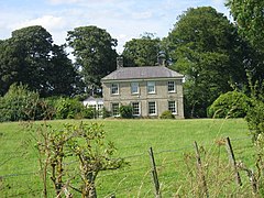
 Beanley Hall | |
Location within
Northumberland | |
| OS grid reference | NU085185 |
| Civil parish | |
| Unitary authority | |
| Shire county | |
| Region | |
| Country | England |
| Sovereign state | United Kingdom |
| Post town | ALNWICK |
| Postcode district | NE66 |
| Police | Northumbria |
| Fire | Northumberland |
| Ambulance | North East |
| UK Parliament | |
Beanley is a village and former civil parish, now in the parish of Hedgeley in the county of Northumberland, England. It is situated to the north-west of Alnwick, near Eglingham. In 1951 the parish had a population of 53. [1]
In 1870–1872, John Marius Wilson's Imperial Gazetteer of England and Wales described Beanley as "a township in Eglingham parish, Northumberland; on the river Breamish, 7 miles NW of Alnwick. Acres, 2,341. Pop., 116. Houses, 23. The earls of Dunbar anciently held it on the tenure of maintaining a road into Scotland. A cross stands on Hedgeley-moor, at a short distance from the village, erected to the memory of Sir Ralph Percy, who fell in 1464 in a battle with the Yorkists."
Governance
Beanley is in the parliamentary constituency of Berwick-upon-Tweed. Beanley was formerly a township in Eglingham parish, [2] from 1866 Beanley was a civil parish in its own right until it was abolished on 1 April 1955 and merged with Hedgeley. [3]
See also
References
- ^ "Population statistics Beanley Tn/CP through time". A Vision of Britain through Time. Retrieved 17 January 2022.
- ^ "History of Beanley, in Alnwick and Northumberland". A Vision of Britain through Time. Retrieved 17 January 2022.
- ^ "Relationships and changes Beanley Tn/CP through time". A Vision of Britain through Time. Retrieved 17 January 2022.
External links
| Beanley | |
|---|---|
 Beanley Hall | |
Location within
Northumberland | |
| OS grid reference | NU085185 |
| Civil parish | |
| Unitary authority | |
| Shire county | |
| Region | |
| Country | England |
| Sovereign state | United Kingdom |
| Post town | ALNWICK |
| Postcode district | NE66 |
| Police | Northumbria |
| Fire | Northumberland |
| Ambulance | North East |
| UK Parliament | |
Beanley is a village and former civil parish, now in the parish of Hedgeley in the county of Northumberland, England. It is situated to the north-west of Alnwick, near Eglingham. In 1951 the parish had a population of 53. [1]
In 1870–1872, John Marius Wilson's Imperial Gazetteer of England and Wales described Beanley as "a township in Eglingham parish, Northumberland; on the river Breamish, 7 miles NW of Alnwick. Acres, 2,341. Pop., 116. Houses, 23. The earls of Dunbar anciently held it on the tenure of maintaining a road into Scotland. A cross stands on Hedgeley-moor, at a short distance from the village, erected to the memory of Sir Ralph Percy, who fell in 1464 in a battle with the Yorkists."
Governance
Beanley is in the parliamentary constituency of Berwick-upon-Tweed. Beanley was formerly a township in Eglingham parish, [2] from 1866 Beanley was a civil parish in its own right until it was abolished on 1 April 1955 and merged with Hedgeley. [3]
See also
References
- ^ "Population statistics Beanley Tn/CP through time". A Vision of Britain through Time. Retrieved 17 January 2022.
- ^ "History of Beanley, in Alnwick and Northumberland". A Vision of Britain through Time. Retrieved 17 January 2022.
- ^ "Relationships and changes Beanley Tn/CP through time". A Vision of Britain through Time. Retrieved 17 January 2022.
External links
