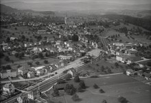
Bazenheid ( Allemannic German: Bàzehäid) is a village in the municipality of Kirchberg, located in the canton of St. Gallen.
As of 2013, a population of 3560 lives there and it contains approximately 30% foreigners. [1]
It was first mentioned in 779 as Pacinuueidu. [2] [3]
Football team FC Bazenheid play there.
References
- ^ Dudle, Simon (23 August 2018). "Wie ein Unternehmen die Struktur eines Dorfes verändern kann". hallowil.ch. Archived from the original on 2020-06-27.
- ^ "ortsnamen.ch - Suche". search.toponymes.ch. Retrieved 2020-12-25.
- ^ "I 63". e-chartae | Stiftsarchiv St. Gallen. Archived from the original on 2020-06-05. Retrieved 2020-12-25.
External links
| International | |
|---|---|
| National | |
| Other | |
47°24′44″N 9°04′07″E / 47.41222°N 9.06861°E
|
| This Canton of St. Gallen location article is a stub. You can help Wikipedia by expanding it. |