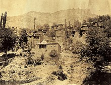

Baz ( Syriac: ܒܙ) was one of the five independent Assyrian tribes of the Hakkari region. [1]
History
Maha Khtayya was the chief village of the region, followed by Shwawwa. [2]
The Assyrians of the Baz tribe were renowned carpenters and iron-workers who worked not only in their villages, but throughout Mosul and other large towns of Upper Mesopotamia. [3]
Assyrian Villages in Baz, Turkey
The Assyrian settlements that traditionally comprised the Baz region in Hakkari consist of the following villages. [2] [4] The region has been empty since they were abandoned in 1915 due to the Assyrian genocide. [2]
- Arwantus (Artusnaye)
- Shwawwa (Shawutnaye)
- Maha Khtayya (Mahaye) (37°27 N, 43°53 E)
- Be-Selim (Selimnaye)
- Argab (Argabaye)
- Kojij (Kojijnaye)
Current Baznaye settlements
These are the villages occupied after the Baznaye were resettled by the British in 1920s and the French in the 1930s.

- Babilo (Shawutnaye)
- Bagereh (Selimnaye)
- Chaqala (Kojijnaye)
- Sardarawa (Artusnaye)
- Sorka (Mahaye)
- Simele (Mahaye)
- Badarrash (Artusnaye)
- Sarsing (Artusnaye)
- Sikren (Selimnaye)
- Sedar (Shawutnaye)
- Pirozawa (Argabaye)
- Ain Sifni (Mixed Baznaye)
- Mawana (Mixed Baznaye)
- Tell Baz (Shawutnaye, Mahaye and some Argabaye) [5] [6]
- Tell Ruman Foqani (Selimnaye and Mahaye) [5] [7]
Famous people
- General Agha Petros Elia - Assyrian military leader during World War I and Chief Negotiator for the * Assyrian/Chaldean/Syriac people during the 1920s.
References
- ^ Wilmshurst, David (2000). The ecclesiastical organisation of the Church of the East, 1318-1913. University of Virginia: Peeters. p. 285. ISBN 9782877235037.
- ^ a b c Mutzafi, Hezy (2000). "The Neo-Aramaic dialect of Maha Khtaya d-Baz. Phonology, morphology and texts". Journal of Semitic Studies. 45: 293, 294. doi: 10.1093/jss/45.2.293.
- ^ Maunsell, F.R. (1901). "Central Kurdistan". The Geographical Journal. 18 (2): 138. doi: 10.2307/1775333. JSTOR 1775333.
- ^ Ainsworth, William (1841). "An Account of a Visit to the Chaldeans, Inhabiting Central Kurdistan; And of an Ascent of the Peak of Rowandiz (Tur Sheikhiwa) in Summer in 1840". Journal of the Royal Geographical Society of London. 11: 35. doi: 10.2307/1797632. JSTOR 1797632.
- ^ a b Dodge, Bayard (1 July 1940). "The settlement of the Assyrians on the Khabbur". Journal of the Royal Central Asian Society. 27 (3): 314. doi: 10.1080/03068374008730969. ISSN 0035-8789.
- ^ Fernandez, Alberto M. (1998). "Dawn at Tell Tamir: The Assyrian Christian Survival on the Khabur River" (PDF). Journal of Assyrian Academic Studies. 12 (1): 41, 42. Archived from the original (PDF) on 2016-08-28. Retrieved 2020-04-25.
- ^ Fernandez, Alberto M. (1998). "Dawn at Tell Tamir: The Assyrian Christian Survival on the Khabur River" (PDF). Journal of Assyrian Academic Studies. 12 (1): 41, 42. Archived from the original (PDF) on 2016-08-28. Retrieved 2020-04-25.


Baz ( Syriac: ܒܙ) was one of the five independent Assyrian tribes of the Hakkari region. [1]
History
Maha Khtayya was the chief village of the region, followed by Shwawwa. [2]
The Assyrians of the Baz tribe were renowned carpenters and iron-workers who worked not only in their villages, but throughout Mosul and other large towns of Upper Mesopotamia. [3]
Assyrian Villages in Baz, Turkey
The Assyrian settlements that traditionally comprised the Baz region in Hakkari consist of the following villages. [2] [4] The region has been empty since they were abandoned in 1915 due to the Assyrian genocide. [2]
- Arwantus (Artusnaye)
- Shwawwa (Shawutnaye)
- Maha Khtayya (Mahaye) (37°27 N, 43°53 E)
- Be-Selim (Selimnaye)
- Argab (Argabaye)
- Kojij (Kojijnaye)
Current Baznaye settlements
These are the villages occupied after the Baznaye were resettled by the British in 1920s and the French in the 1930s.

- Babilo (Shawutnaye)
- Bagereh (Selimnaye)
- Chaqala (Kojijnaye)
- Sardarawa (Artusnaye)
- Sorka (Mahaye)
- Simele (Mahaye)
- Badarrash (Artusnaye)
- Sarsing (Artusnaye)
- Sikren (Selimnaye)
- Sedar (Shawutnaye)
- Pirozawa (Argabaye)
- Ain Sifni (Mixed Baznaye)
- Mawana (Mixed Baznaye)
- Tell Baz (Shawutnaye, Mahaye and some Argabaye) [5] [6]
- Tell Ruman Foqani (Selimnaye and Mahaye) [5] [7]
Famous people
- General Agha Petros Elia - Assyrian military leader during World War I and Chief Negotiator for the * Assyrian/Chaldean/Syriac people during the 1920s.
References
- ^ Wilmshurst, David (2000). The ecclesiastical organisation of the Church of the East, 1318-1913. University of Virginia: Peeters. p. 285. ISBN 9782877235037.
- ^ a b c Mutzafi, Hezy (2000). "The Neo-Aramaic dialect of Maha Khtaya d-Baz. Phonology, morphology and texts". Journal of Semitic Studies. 45: 293, 294. doi: 10.1093/jss/45.2.293.
- ^ Maunsell, F.R. (1901). "Central Kurdistan". The Geographical Journal. 18 (2): 138. doi: 10.2307/1775333. JSTOR 1775333.
- ^ Ainsworth, William (1841). "An Account of a Visit to the Chaldeans, Inhabiting Central Kurdistan; And of an Ascent of the Peak of Rowandiz (Tur Sheikhiwa) in Summer in 1840". Journal of the Royal Geographical Society of London. 11: 35. doi: 10.2307/1797632. JSTOR 1797632.
- ^ a b Dodge, Bayard (1 July 1940). "The settlement of the Assyrians on the Khabbur". Journal of the Royal Central Asian Society. 27 (3): 314. doi: 10.1080/03068374008730969. ISSN 0035-8789.
- ^ Fernandez, Alberto M. (1998). "Dawn at Tell Tamir: The Assyrian Christian Survival on the Khabur River" (PDF). Journal of Assyrian Academic Studies. 12 (1): 41, 42. Archived from the original (PDF) on 2016-08-28. Retrieved 2020-04-25.
- ^ Fernandez, Alberto M. (1998). "Dawn at Tell Tamir: The Assyrian Christian Survival on the Khabur River" (PDF). Journal of Assyrian Academic Studies. 12 (1): 41, 42. Archived from the original (PDF) on 2016-08-28. Retrieved 2020-04-25.