Photos • Location
| Barrow Hill | |
|---|---|
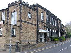
 Barrow Hill Memorial Hall | |
Location within
Derbyshire | |
| OS grid reference | SK4175 |
| District | |
| Shire county | |
| Region | |
| Country | England |
| Sovereign state | United Kingdom |
| Post town | Chesterfield |
| Postcode district | S43 |
| Dialling code | 01246 |
| Police | Derbyshire |
| Fire | Derbyshire |
| Ambulance | East Midlands |
| UK Parliament | |
Barrow Hill is a village in Derbyshire, England, north-east of Chesterfield in the civil parish of Staveley. It was formerly the site of Barrow Hill railway station, and now Barrow Hill Engine Shed.
It is the local authority ward of Barrow Hill and New Whittington, which in 2011 had a population of 5,903. [1]
References
- ^ UK Census (2011). "Local Area Report – Barrow Hill and New Whittington Ward (as of 2011) (E05003323)". Nomis. Office for National Statistics. Retrieved 7 November 2021.
| Barrow Hill | |
|---|---|
 Barrow Hill Memorial Hall | |
Location within
Derbyshire | |
| OS grid reference | SK4175 |
| District | |
| Shire county | |
| Region | |
| Country | England |
| Sovereign state | United Kingdom |
| Post town | Chesterfield |
| Postcode district | S43 |
| Dialling code | 01246 |
| Police | Derbyshire |
| Fire | Derbyshire |
| Ambulance | East Midlands |
| UK Parliament | |
Barrow Hill is a village in Derbyshire, England, north-east of Chesterfield in the civil parish of Staveley. It was formerly the site of Barrow Hill railway station, and now Barrow Hill Engine Shed.
It is the local authority ward of Barrow Hill and New Whittington, which in 2011 had a population of 5,903. [1]
References
- ^ UK Census (2011). "Local Area Report – Barrow Hill and New Whittington Ward (as of 2011) (E05003323)". Nomis. Office for National Statistics. Retrieved 7 November 2021.
