| Bab Doukkala | |
|---|---|
باب دكالة | |
 | |
|
| |
| General information | |
| Type | city gate |
| Architectural style | Almoravid, Moorish, Moroccan |
| Location | Marrakesh, Morocco |
| Coordinates | 31°38′2.2″N 7°59′56.4″W / 31.633944°N 7.999000°W |
| Completed | circa 1126 |
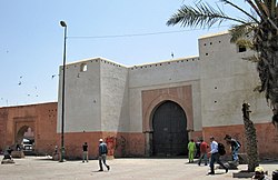
Bab Doukkala ( Arabic: باب دكالة, lit. 'gate of the Doukkala') is the main northwestern gate of the medina (historic walled city) of Marrakesh, Morocco.
The gate dates back to around 1126 CE when the Almoravid emir Ali ibn Yusuf built the first walls of the city. [1] [2] Doukkala, was that of both a Berber tribe and of a region between Marrakesh and Casablanca today. [1] Unlike many other gates of the city, it has not been subject to major modifications (at least in its floor plan) and retains its original sophisticated bent entrance design from the Almoravid period. The passage inside the gate bends at a straight angle twice: one enters from the west, turns south, then turns east before emerging into the city. [1] [3] Today the gate is flanked by other simple openings in the wall to allow for easy circulation. The city's main intercity bus terminal is also located just outside and slightly north of Bab Doukkala gate. [4] [5]
-
Floor plan of Bab Doukkala (the light grey shaded areas indicate roofed areas inside the gate)
-
Bab Doukkala exterior (western) facade
-
Bab Doukkala inner (eastern) facade
- ^ a b c Allain, Charles; Deverdun, Gaston (1957). "Les portes anciennes de Marrakech". Hespéris. 44: 85–126. Archived from the original on 2021-02-28. Retrieved 2020-09-09.
- ^ Deverdun, Gaston (1959). Marrakech: Des origines à 1912. Rabat: Éditions Techniques Nord-Africaines.
- ^ Wilbaux, Quentin (2001). La médina de Marrakech: Formation des espaces urbains d'une ancienne capitale du Maroc. Paris: L'Harmattan. ISBN 2747523888.
- ^ "Bus Travel - Marrakesh". Fodor's. Retrieved 2020-09-09.
- ^ "Gare Routière | Marrakesh, Morocco Transportation". Lonely Planet. Retrieved 2020-09-09.
| Bab Doukkala | |
|---|---|
باب دكالة | |
 | |
|
| |
| General information | |
| Type | city gate |
| Architectural style | Almoravid, Moorish, Moroccan |
| Location | Marrakesh, Morocco |
| Coordinates | 31°38′2.2″N 7°59′56.4″W / 31.633944°N 7.999000°W |
| Completed | circa 1126 |
Bab Doukkala ( Arabic: باب دكالة, lit. 'gate of the Doukkala') is the main northwestern gate of the medina (historic walled city) of Marrakesh, Morocco.
The gate dates back to around 1126 CE when the Almoravid emir Ali ibn Yusuf built the first walls of the city. [1] [2] Doukkala, was that of both a Berber tribe and of a region between Marrakesh and Casablanca today. [1] Unlike many other gates of the city, it has not been subject to major modifications (at least in its floor plan) and retains its original sophisticated bent entrance design from the Almoravid period. The passage inside the gate bends at a straight angle twice: one enters from the west, turns south, then turns east before emerging into the city. [1] [3] Today the gate is flanked by other simple openings in the wall to allow for easy circulation. The city's main intercity bus terminal is also located just outside and slightly north of Bab Doukkala gate. [4] [5]
-
Floor plan of Bab Doukkala (the light grey shaded areas indicate roofed areas inside the gate)
-
Bab Doukkala exterior (western) facade
-
Bab Doukkala inner (eastern) facade
- ^ a b c Allain, Charles; Deverdun, Gaston (1957). "Les portes anciennes de Marrakech". Hespéris. 44: 85–126. Archived from the original on 2021-02-28. Retrieved 2020-09-09.
- ^ Deverdun, Gaston (1959). Marrakech: Des origines à 1912. Rabat: Éditions Techniques Nord-Africaines.
- ^ Wilbaux, Quentin (2001). La médina de Marrakech: Formation des espaces urbains d'une ancienne capitale du Maroc. Paris: L'Harmattan. ISBN 2747523888.
- ^ "Bus Travel - Marrakesh". Fodor's. Retrieved 2020-09-09.
- ^ "Gare Routière | Marrakesh, Morocco Transportation". Lonely Planet. Retrieved 2020-09-09.


