Baambrugge | |
|---|---|
Town | |
 | |
 | |
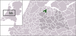
 The town centre (dark green) and the statistical district (light green) of Baambrugge in the municipality of Abcoude. | |
| Coordinates: 52°14′46″N 4°59′19″E / 52.24611°N 4.98861°E | |
| Country | Netherlands |
| Province | Utrecht |
| Municipality | De Ronde Venen |
| Population (2007) | |
| • Total | 1,100 |
| Time zone | UTC+1 ( CET) |
| • Summer ( DST) | UTC+2 ( CEST) |

Baambrugge is a village on the river Angstel in the Dutch province of Utrecht. It is a part of the municipality of De Ronde Venen and lies about 14 km southeast of Amsterdam. In 2001 the village of Baambrugge had 925 inhabitants. The built-up area of the town was 0.21 km² and contained 365 residences. [1] The statistical area "Baambrugge", which also can include the peripheral parts of the village, as well as the surrounding countryside, has a population of around 1000. [2]
History
The village used to be a separate municipality, under the name Abcoude-Baambrugge. In 1941, it merged with Abcoude-Proosdij to form the municipality Abcoude.
The Beach Boys recorded their 1973 album Holland in Baambrugge, using a reconstructed studio sent from California.
The town used to have many small shops but only one is still there.
References
- ^ Statistics Netherlands (CBS), Bevolkingskernen in Nederland 2001 Archived 2007-01-24 at the Wayback Machine. (Statistics are for the continuous built-up area).
- ^ Statistics Netherlands (CBS), Statline: Kerncijfers wijken en buurten 2003-2005 Archived 1999-04-27 at the Wayback Machine. As of 1 January 2005.
External links
-
 Media related to
Baambrugge at Wikimedia Commons
Baambrugge | |
|---|---|
Town | |
 | |
 | |
 The town centre (dark green) and the statistical district (light green) of Baambrugge in the municipality of Abcoude. | |
| Coordinates: 52°14′46″N 4°59′19″E / 52.24611°N 4.98861°E | |
| Country | Netherlands |
| Province | Utrecht |
| Municipality | De Ronde Venen |
| Population (2007) | |
| • Total | 1,100 |
| Time zone | UTC+1 ( CET) |
| • Summer ( DST) | UTC+2 ( CEST) |

Baambrugge is a village on the river Angstel in the Dutch province of Utrecht. It is a part of the municipality of De Ronde Venen and lies about 14 km southeast of Amsterdam. In 2001 the village of Baambrugge had 925 inhabitants. The built-up area of the town was 0.21 km² and contained 365 residences. [1] The statistical area "Baambrugge", which also can include the peripheral parts of the village, as well as the surrounding countryside, has a population of around 1000. [2]
History
The village used to be a separate municipality, under the name Abcoude-Baambrugge. In 1941, it merged with Abcoude-Proosdij to form the municipality Abcoude.
The Beach Boys recorded their 1973 album Holland in Baambrugge, using a reconstructed studio sent from California.
The town used to have many small shops but only one is still there.
References
- ^ Statistics Netherlands (CBS), Bevolkingskernen in Nederland 2001 Archived 2007-01-24 at the Wayback Machine. (Statistics are for the continuous built-up area).
- ^ Statistics Netherlands (CBS), Statline: Kerncijfers wijken en buurten 2003-2005 Archived 1999-04-27 at the Wayback Machine. As of 1 January 2005.
External links
-
 Media related to
Baambrugge at Wikimedia Commons