Bąków | |
|---|---|
Village | |
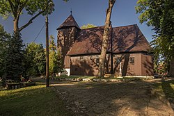
 Church of the Assumption in Bąków | |
| Coordinates: 50°58′N 18°19′E / 50.967°N 18.317°E | |
| Country |
|
| Voivodeship | Opole |
| County | Kluczbork |
| Gmina | Kluczbork |
| First mentioned | 1258 |
| Population | 1,400 |
| Time zone | UTC+1 ( CET) |
| • Summer ( DST) | UTC+2 ( CEST) |
| Vehicle registration | OKL |
| National roads |
|
| Website | www.bakow.pl |
Bąków ( [ˈbɔnkuf]) is a village in the administrative district of Gmina Kluczbork, within Kluczbork County, Opole Voivodeship, in southern Poland. [1] It lies approximately 8 kilometres (5 mi) east of Kluczbork and 43 km (27 mi) north-east of the regional capital Opole.
The village was first mentioned in 1258, when it was part of fragmented Piast-ruled Poland. In the past, it was also known in Polish as Bęk. [2]
During World War II, in 1944, the Germans relocated the Stalag Luft 7 prisoner-of-war camp from Morzyczyn to Bąków. [3] [4] It housed Allied POWs of various nationalities, including British, Canadian, American, Polish, Australian, New Zealander, South African, French and Dutch. [3] [4] On 19 January 1945, the Germans evacuated the camp in a death march, which reached the Stalag III-A camp in Luckenwalde on February 8. [3] [5] Following Germany's defeat in the war, the village became again part of Poland.
Heritage sites of Bąków include the old wooden Church of the Assumption and a historic palace.
There is a train station in Bąków. The Polish National road 11 passes through the village.
- Walter Scheunemann (1909–1949), German Wehrmacht officer
- Otto Hoffmann von Waldau (1898–1943), German Luftwaffe general
- ^ "Central Statistical Office (GUS) - TERYT (National Register of Territorial Land Apportionment Journal)" (in Polish). 2008-06-01.
-
^ Słownik geograficzny Królestwa Polskiego i innych krajów słowiańskich, Tom I (in Polish). Warsaw. 1880. p. 167.
{{
cite book}}
: CS1 maint: location missing publisher ( link) - ^ a b c Megargee, Geoffrey P.; Overmans, Rüdiger; Vogt, Wolfgang (2022). The United States Holocaust Memorial Museum Encyclopedia of Camps and Ghettos 1933–1945. Volume IV. Indiana University Press, United States Holocaust Memorial Museum. p. 510. ISBN 978-0-253-06089-1.
- ^ a b Stanek, Piotr (2015). "Stalag Luft 7 Bankau i jego ewakuacja na Zachód w styczniu 1945 r.". Łambinowicki rocznik muzealny (in Polish). 38. Opole: 53. ISSN 0137-5199.
- ^ Stanek, p. 64
Bąków | |
|---|---|
Village | |
 Church of the Assumption in Bąków | |
| Coordinates: 50°58′N 18°19′E / 50.967°N 18.317°E | |
| Country |
|
| Voivodeship | Opole |
| County | Kluczbork |
| Gmina | Kluczbork |
| First mentioned | 1258 |
| Population | 1,400 |
| Time zone | UTC+1 ( CET) |
| • Summer ( DST) | UTC+2 ( CEST) |
| Vehicle registration | OKL |
| National roads |
|
| Website | www.bakow.pl |
Bąków ( [ˈbɔnkuf]) is a village in the administrative district of Gmina Kluczbork, within Kluczbork County, Opole Voivodeship, in southern Poland. [1] It lies approximately 8 kilometres (5 mi) east of Kluczbork and 43 km (27 mi) north-east of the regional capital Opole.
The village was first mentioned in 1258, when it was part of fragmented Piast-ruled Poland. In the past, it was also known in Polish as Bęk. [2]
During World War II, in 1944, the Germans relocated the Stalag Luft 7 prisoner-of-war camp from Morzyczyn to Bąków. [3] [4] It housed Allied POWs of various nationalities, including British, Canadian, American, Polish, Australian, New Zealander, South African, French and Dutch. [3] [4] On 19 January 1945, the Germans evacuated the camp in a death march, which reached the Stalag III-A camp in Luckenwalde on February 8. [3] [5] Following Germany's defeat in the war, the village became again part of Poland.
Heritage sites of Bąków include the old wooden Church of the Assumption and a historic palace.
There is a train station in Bąków. The Polish National road 11 passes through the village.
- Walter Scheunemann (1909–1949), German Wehrmacht officer
- Otto Hoffmann von Waldau (1898–1943), German Luftwaffe general
- ^ "Central Statistical Office (GUS) - TERYT (National Register of Territorial Land Apportionment Journal)" (in Polish). 2008-06-01.
-
^ Słownik geograficzny Królestwa Polskiego i innych krajów słowiańskich, Tom I (in Polish). Warsaw. 1880. p. 167.
{{
cite book}}
: CS1 maint: location missing publisher ( link) - ^ a b c Megargee, Geoffrey P.; Overmans, Rüdiger; Vogt, Wolfgang (2022). The United States Holocaust Memorial Museum Encyclopedia of Camps and Ghettos 1933–1945. Volume IV. Indiana University Press, United States Holocaust Memorial Museum. p. 510. ISBN 978-0-253-06089-1.
- ^ a b Stanek, Piotr (2015). "Stalag Luft 7 Bankau i jego ewakuacja na Zachód w styczniu 1945 r.". Łambinowicki rocznik muzealny (in Polish). 38. Opole: 53. ISSN 0137-5199.
- ^ Stanek, p. 64

