Photos • Location
(Redirected from
Bình Tân District, Vĩnh Long Province)
You can help expand this article with text translated from
the corresponding article in Vietnamese. (March 2009) Click [show] for important translation instructions.
|
Binh Tan district
Huyện Bình Tân | |
|---|---|
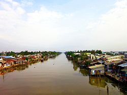
 Bà market, Thành Lợi | |
| Country | |
| Region | Mekong Delta |
| Province | Vĩnh Long |
| Capital | Tân Quới |
| Area | |
| • Total | 5,903 sq mi (15,289 km2) |
| Population (2009) | |
| • Total | 93.758 |
| Time zone | UTC+7 (UTC + 7) |
Bình Tân is a rural district (huyện) of Vĩnh Long province in the Mekong Delta region of Vietnam.
(Redirected from
Bình Tân District, Vĩnh Long Province)
You can help expand this article with text translated from
the corresponding article in Vietnamese. (March 2009) Click [show] for important translation instructions.
|
Binh Tan district
Huyện Bình Tân | |
|---|---|
 Bà market, Thành Lợi | |
| Country | |
| Region | Mekong Delta |
| Province | Vĩnh Long |
| Capital | Tân Quới |
| Area | |
| • Total | 5,903 sq mi (15,289 km2) |
| Population (2009) | |
| • Total | 93.758 |
| Time zone | UTC+7 (UTC + 7) |
Bình Tân is a rural district (huyện) of Vĩnh Long province in the Mekong Delta region of Vietnam.
