Photos • Location
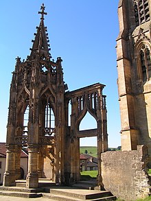
The Recevresse


Avioth | |
|---|---|
 Our Lady's basilica | |
 Avioth  Avioth | |
| Coordinates: 49°34′02″N 5°23′30″E / 49.5672°N 5.3917°E | |
| Country | France |
| Region | Grand Est |
| Department | Meuse |
| Arrondissement | Verdun |
| Canton | Montmédy |
| Intercommunality | CC Pays Montmédy |
| Government | |
| • Mayor (2020–2026) | Laurent Geoffroy [1] |
| Area 1 | 6.5 km2 (2.5 sq mi) |
| Population (2021)
[2] | 130 |
| • Density | 20/km2 (52/sq mi) |
| Time zone | UTC+01:00 ( CET) |
| • Summer ( DST) | UTC+02:00 ( CEST) |
| INSEE/Postal code |
55022 /55600 |
| Elevation | 196–315 m (643–1,033 ft) (avg. 215 m or 705 ft) |
| 1 French Land Register data, which excludes lakes, ponds, glaciers > 1 km2 (0.386 sq mi or 247 acres) and river estuaries. | |
Avioth (French pronunciation: [avjɔt]) is a commune in the Meuse department in the Grand Est region in northeastern France. The monumental church was built in the 13th-15th century. [3] Next to the church is the 15th century flamboyant gothic chapel la Recevresse. [4]
| Year | Pop. | ±% p.a. |
|---|---|---|
| 1968 | 152 | — |
| 1975 | 108 | −4.76% |
| 1982 | 103 | −0.67% |
| 1990 | 122 | +2.14% |
| 1999 | 115 | −0.65% |
| 2009 | 128 | +1.08% |
| 2014 | 138 | +1.52% |
| 2020 | 141 | +0.36% |
| Source: INSEE [5] | ||

- ^ "Répertoire national des élus: les maires". data.gouv.fr, Plateforme ouverte des données publiques françaises (in French). 9 August 2021.
- ^ "Populations légales 2021" (in French). The National Institute of Statistics and Economic Studies. 28 December 2023.
- ^ Base Mérimée: Eglise paroissiale Saint-Brice dite Eglise Notre-Dame-d'Avioth, Ministère français de la Culture. (in French)
- ^ Base Mérimée: Édifice non identifié dit la Recevresse, Ministère français de la Culture. (in French)
- ^ Population en historique depuis 1968, INSEE
Wikimedia Commons has media related to
Avioth.
| International | |
|---|---|
| National | |
|
| This Meuse geographical article is a stub. You can help Wikipedia by expanding it. |
Avioth | |
|---|---|
|
Our Lady's basilica | |
Avioth Avioth | |
| Coordinates: 49°34′02″N 5°23′30″E / 49.5672°N 5.3917°E | |
| Country | France |
| Region | Grand Est |
| Department | Meuse |
| Arrondissement | Verdun |
| Canton | Montmédy |
| Intercommunality | CC Pays Montmédy |
| Government | |
| • Mayor (2020–2026) | Laurent Geoffroy [1] |
| Area 1 | 6.5 km2 (2.5 sq mi) |
| Population (2021)
[2] | 130 |
| • Density | 20/km2 (52/sq mi) |
| Time zone | UTC+01:00 ( CET) |
| • Summer ( DST) | UTC+02:00 ( CEST) |
| INSEE/Postal code |
55022 /55600 |
| Elevation | 196–315 m (643–1,033 ft) (avg. 215 m or 705 ft) |
| 1 French Land Register data, which excludes lakes, ponds, glaciers > 1 km2 (0.386 sq mi or 247 acres) and river estuaries. | |
Avioth (French pronunciation: [avjɔt]) is a commune in the Meuse department in the Grand Est region in northeastern France. The monumental church was built in the 13th-15th century. [3] Next to the church is the 15th century flamboyant gothic chapel la Recevresse. [4]
| Year | Pop. | ±% p.a. |
|---|---|---|
| 1968 | 152 | — |
| 1975 | 108 | −4.76% |
| 1982 | 103 | −0.67% |
| 1990 | 122 | +2.14% |
| 1999 | 115 | −0.65% |
| 2009 | 128 | +1.08% |
| 2014 | 138 | +1.52% |
| 2020 | 141 | +0.36% |
| Source: INSEE [5] | ||
- ^ "Répertoire national des élus: les maires". data.gouv.fr, Plateforme ouverte des données publiques françaises (in French). 9 August 2021.
- ^ "Populations légales 2021" (in French). The National Institute of Statistics and Economic Studies. 28 December 2023.
- ^ Base Mérimée: Eglise paroissiale Saint-Brice dite Eglise Notre-Dame-d'Avioth, Ministère français de la Culture. (in French)
- ^ Base Mérimée: Édifice non identifié dit la Recevresse, Ministère français de la Culture. (in French)
- ^ Population en historique depuis 1968, INSEE
Wikimedia Commons has media related to
Avioth.
| International | |
|---|---|
| National | |
|
| This Meuse geographical article is a stub. You can help Wikipedia by expanding it. |